1817 Thomson Map of Africa
Africa-thomson-1817$350.00

Title
Africa.
1817 (undated) 19 x 22 in (48.26 x 55.88 cm) 1 : 20000000
1817 (undated) 19 x 22 in (48.26 x 55.88 cm) 1 : 20000000
Description
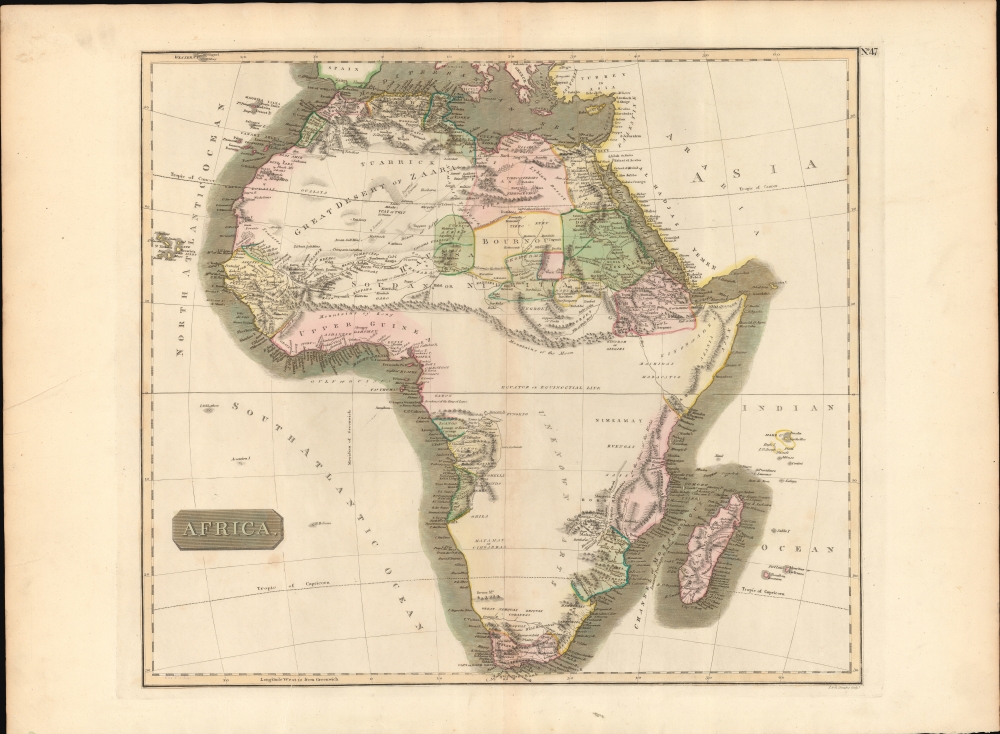
This is John Thomson's fascinating 1814 map of Africa, here in its first edition. This map is as engrossing as much for what it doesn't show as for what it does. The expansive blank interior, here labeled, 'unknown parts' reveals just how little of the 'Dark Continent' was known in the early 19th century.
A Closer Look
On this map exploration is limited to the Nile Valley, the costal Mediterranean lands, Abyssinia, the Niger Valley, the Congo, South Africa, and the Mozambique Coast. A large and fictive mountain range, alternately labeled the Mountains of Kong or the Mountain of the Moon, stretches across the continent. This range is a combination of Ptolemaic conventions on the source of the White Nile, as well the speculations of Mungo Park on the sources of the Niger. Further south Lake Malawi (l. Maravi) appears in embryonic form, most likely gleaned from indigenous reports, and is suggestive of the great lakes of the Rift Valley.Caravan Routes
Caravan routes crisscross the Sahara, alternatively labeled 'Great Desert'. Some of these routes are given exotic names such as 'Desert of 20 Journies' referring to the number of days it takes to cross that expanse. In addition, several late 18th and early 19th century exploratory routes are identified.Publication History and Census
This map was prepared and engraved in c. 1816 in Edinburgh by J. and G. Menzies for inclusion in the 1817 first edition of John Thomson's New General Atlas.CartographerS
John Thomson (1777 - c. 1841) was a Scottish cartographer, publisher, and bookbinder active in Edinburgh during the early part of the 19th century. Thomson apprenticed under Edinburgh bookbinder Robert Alison. After his apprenticeship, he briefly went into business with Abraham Thomson. Later, the two parted ways, John Thomson segueing into maps and Abraham Thomson taking over the bookbinding portion of the business. Thomson is generally one of the leading publishers in the Edinburgh school of cartography, which flourished from roughly 1800 to 1830. Thomson and his contemporaries (Pinkerton and Cary) redefined European cartography by abandoning typical 18th-century decorative elements such as elaborate title cartouches and fantastic beasts in favor of detail and accuracy. Thomson's principle works include Thomson's New General Atlas, published from 1814 to 1821, the New Classical and Historical Atlas of 1829, and his 1830 Atlas of Scotland. The Atlas of Scotland, a work of groundbreaking detail and dedication, would eventually bankrupt the Thomson firm in 1830, at which time their plates were sequestered by the court. The firm partially recovered in the subsequent year, allowing Thomson to reclaim his printing plates in 1831, but filed again for bankruptcy in 1835, at which time most of his printing plates were sold to A. K. Johnston and Company. There is some suggestion that he continued to work as a bookbinder until 1841. Today, Thomson maps are becoming increasingly rare as they are highly admired for their impressive size, vivid hand coloration, and superb detail. More by this mapmaker...
John Menzies (October 27, 1772 - October 16, 1857) was a Scottish engraver active in Edinburgh during the late 18th and early 19th centuries. Menzies mastered engraving as an apprentice to James Rymer. In 1811, he partnered with his younger brother, George Menzies, to found the engraving firm of J. and G. Menzies, which was active until about 1831. Later his son, also named John, joined the firm and they engraved jointly under the imprint of J. Menzies and Son. At its height, the Menzies firm employed three men and three apprentices. Menzies engraved maps for Thomas Brown and John Thomson, among others. After his death, his son, John Menzies II (1819 – 1891), continued the family business until about 1891. Learn More...
Source
Thomson, J., A New General Atlas, (Edinburgh: Baldwin, Cradock, Joy) 1817.
Thomson's New General Atlas was first published in 1817 and continued to be published until about 1821. This is the first of Thomson's major cartographic works and the atlas for which is most celebrated. The New General Atlas follows in the Edinburgh School, which eschews excessive decoration in favor of a more minimalistic fact-based cartographic vision, as established by John Pinkerton, Laurie and Whittle, John Cary, and others in the previous decades. The maps are notable for their massive scale, heavy stock, elegant color work, and easy-to-read typefaces. Although the atlas stopped being published after 1821, Thomson continued to offer 'supplementary' maps that could be tipped into the atlas as late as 1830, when he declared bankruptcy. The maps in the Thomson Atlas were engraved by Thomas Clerk, William Dassauville, Nathaniel Rogers Hewitt, James Kirkwood, Robert Kirkwood, John Menzies, George Menzies, Edward Mitchell, John Moffatt, Samuel John Neele, Robert Scott, and James Wyld.
Condition
Very good. Original centerfold.
References
Rumsey 1007.051. Tooley, R.V., Maps of Africa, p. 101.