1745 De Wit / Ottens Map of Africa and the Arabian Peninsula
AfricaArabia-ottens-1745$825.00

Title
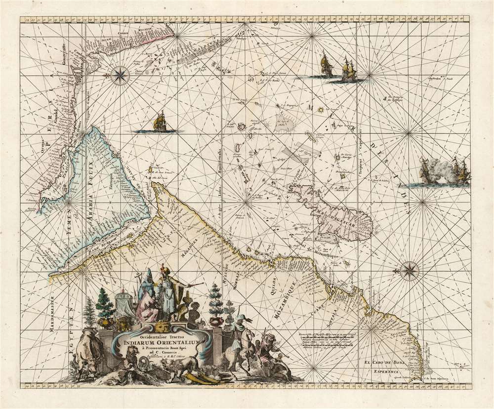
Occidentalior Tractus Indiarum Orientalium à Promontorio Bonae Spei ad C. Comorin.
1745 (undated) 17.25 x 21 in (43.815 x 53.34 cm) 1 : 16726000
1745 (undated) 17.25 x 21 in (43.815 x 53.34 cm) 1 : 16726000
Description
This is Frederic De Wit's map of Africa, Arabia, and part of India, in a handsome example of its scarce 1745 edition printed by Renier and Joshua Ottens. The map represents a key passage in the East India trade routes across the Indian Ocean. It is, moreover, a fine example of the highpoint of Dutch engraving - the work of master engraver Romeyn De Hooghe.
A Closer Look
Presented as a nautical chart replete with compass roses and rhumb lines, the engraving is oriented to the east and focuses exclusively on coastal information, islands, and navigational detail. The chart presents the coastline from Africa's Cape of Good Hope to India's Cape Comorin, including the whole of the Arabian Peninsula, the Red Sea, and the Persian Gulf. Madagascar and a fan of islands stretching to the Maldives are exceptionally well-detailed, emphasizing the navigability of the Indian Ocean directly without recourse to hugging the coast: a key detail for the European trader, who would consider this chart a step along the way to the East Indies.A Masterwork of Etching
Despite its limited utility as a working nautical atlas, De Wit's Zee Atlas experienced a remarkable printing history. One contributing factor to its longevity is its beauty, greatly enhanced on many of its charts by the bravura etching of Romeyn De Hooghe - one of Amsterdam's finest portraitists and engravers. De Wit's chart is embellished with five of De Hooghe's sailing ships, two of which are locked in battle. The cartouche's decoration is a superb specimen of the master's work, meant to emphasize the exoticism of the lands depicted. In the foreground, piled with elephant tusks and other trade goods, a lion roars at a leopard, which rears with a giant serpentine monster pinned under a paw. A water buffalo and an exotic bird look on from the left. To the right rides an Arab horseman near an animal-headdress-wearing figure smoking a pipe - possibly opium. Atop the cartouche, a figure in European ecclesiastical robes kneels before a turbaned figure in finery decorated with a cross: a representation of Prester John, the mythical leader of a long-sought-for Christian empire thought to lie hidden in Eastern Africa.Publication History and Census
The chart first appeared in De Wit’s 1675 Zee Atlas, reprinted by Renard in the early 18th century and again by Ottens in 1745. Sixteen entries for the various editions of this chart are listed in OCLC, but only one of these is the 1745 edition, kept in the Biblioteca Nacional de Espana. The Ottens issues of these maps were often bound in composite atlases rather than in a standard edition of the Atlas de la Navigation , which may account for this issue's scarcity.CartographerS
Frederik de Wit (1629 - 1706) was a Dutch Golden Age cartographer active in the second half of the 17th and the early 18th centuries. De Wit was born of middle class Protestant stock in the western Netherlandish town of Gouda. He relocated to Amsterdam sometime before 1648, where he worked under Willem Blaeu. His first attributed engraved map, a plan of Haarlem for Antonius Sanderus' Flandria Illustrata, was issued around this time. He struck out on his own in 1654. The first chart that De Wit personally both drew and engraved was most likely his 1659 map of Denmark, REGNI DANIÆ Accuratissima delineatio Perfeckte Kaerte van ‘t CONJNCKRYCK DENEMARCKEN. His great wall map of the world and most famous work, Nova Totius Terrarum Orbis Tabula appeared one year later. Following the publication of his wall map De Wit quickly rose in prominence as a both cartographer and engraver. He married Maria van der Way in 1661 and through her became a citizen of Amsterdam in 1662. Around this time he also published his first major atlas, a composite production ranging in size from 17 to over 150 maps and charts. Other atlases and individual maps followed. In 1689 De Wit was granted a 15 year Privilege by the Dutch States General. (An early copyright that protected the recipient's rights to print and publish.) He was recognized with the honorific 'Good Citizen' in 1694. De Wit died in 1706 after which his wife Maria continued publishing his maps until about 1710. De Wit's son, Franciscus, had no interest in the map trade, instead choosing to prosper as a stockfish merchant. On her own retirement, Maria sold most De Wit maps and plates at a public auction. Most were acquired by Pieter Mortier and laid the groundwork for the 1721 rise of Covens and Mortier, the largest Dutch cartographic publishing house of the 18th century. More by this mapmaker...
Ottens (fl. c. 1680 - 1785) was a prominent Amsterdam map publishing family active for nearly 100 years. Joachim Ottens (1663 - 1719) was born in Amsterdam to a family of seafarers and educated in Amsterdam's Evangelical Lutheran community. He likely learned copperplate engraving under Frederick de Wit (1629 - 1706), for whom he worked until about 1710. In 1710, he was admitted to the Sint-Lucasgilde (Guild of St. Luke) and, in 1711, Joachim founded his own firm. Although Joachim died only a few years later, in 1719, his widow continued the business, either publishing as either 'I. Ottens', 'Ottens', or 'In de Wereldcaert' [In the World Map]. In 1726, Joachim Otten's sons, Renier (1698 - 1750) and Joshua (1698 - 1750), established a partnership and generally published as 'R. and I. Ottens'. Although they ran separate shops, on Nieuwendijk and Kalverstraat, they worked jointly as a singular business until Renier's death in 1750, at which point Joshua assumed full control. After Joshua's death in 1765, his widow continued the firm with their son, Renier II, changing the imprint to 'Joshua and Reinier Ottens.' Joshua's widow, Johanna de Lindt, held an auction sale of their engraved plates in 1784. Ottens' work stands out in that all of their maps were separate issues, though often found compiled into special, made-to-order multi-volume composite Atlas factice works, such as the Atlas. Some examples of the Atlas include over 800 separately issued maps. Because they were not uniformly issued in standard atlases, Ottens maps are often of the utmost rarity and are notable for their exceptionally rich engraving. Learn More...
Romeyn de Hooghe (Septemer 10, 1645 – June 10, 1708) was a Dutch engraver, portrait artist, caricaturist, painter, and sculptor active in Amsterdam during the second half of the 17th century and opening years of the 18th century. De Hooghe was born in Amsterdam and revealed an early talent for all forms of visual arts. He became known caricaturist and is admired today as one of the first great graphic satirists. During his life he was criticized for his proclivity towards humorous tongue-in-cheek subjects. He nonetheless developed a following and produced a prolific amount of work, some 5000 engravings. He was a member of the Confrerie Pictura in 1662 and 1683. Cartographically he is best known for his decorative border work. His disciples were Filibert Bouttats (1654-after 1731), Filibertus Bouttats (1635–1707), Frans Decker, François Harrewijn, Jacobus Harrewijn, Aernout Naghtegael, Laurens Scherm, and Adriaen Schoonebeek. De Hooghe died in Haarlem on June 10, 1708. Much of his work continued to be republished posthumously. Learn More...
Condition
Very good. One minor scuff in sea area.
References
OCLC 796367907. Norwich, O. I., Norwich's Maps of Africa: An Illustrated and Annotated Cartobibliography, 256. (De Wit 1680).