This item has been sold, but you can get on the Waitlist to be notified if another example becomes available, or purchase a digital scan.
1828 Owen Nautical Chart Madagascar w/Manuscript Whaling Notes
AfricaMadagascar-owen-1828$825.00

Title
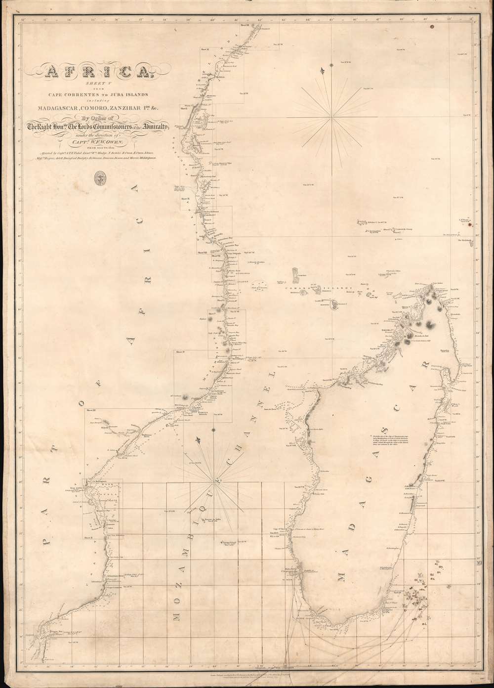
Africa Sheet V from Cape Correntes to Juba Islands including Madagascar, Comoro, Zanzibar Ids. And c.
1828 (dated) 26.5 x 21 in (67.31 x 53.34 cm) 1 : 150000
1828 (dated) 26.5 x 21 in (67.31 x 53.34 cm) 1 : 150000
Description
An exceptional British Admiralty / William Fitzwilliam Owen 1828 nautical chart of Madagascar, Southeast Africa, and the Mozambique Channel, with unique manuscript annotations relating to a series of c. 1852 - 1856 whaling voyages in the south Indian Ocean. The annotations including charmingly illustrated whale tails recording whale sightings and takings, some of which are dated, others of which appear to relate to a numeric key, now lost.
We have identified examples in the British Library, the University of Wisconsin, and the University of Chicago. We have identified examples from 1828 (first issue) and 1865. The present example is the 1828 first edition.
Whaling in Madagascar
Madagascar sits at a unique confluence of currents, including the South Equatorial Current and the East Madagascar Current, which draws various whiles along migratory patterns. The region is particularly rich in Sperm, Humpback, and Bryde whales. East Madagascar, around Antongil Bay, is believed to be an active mating ground for the Humpback Whale. While indigenous whaling off the east coast has been recorded as early as 1598 by Theodor De Bry and others, active whaling by European and American whaling ships did not develop until around 1800. After 1820, the region became synonymous with over whaling. Today, it is designed as a protected zone, part of the Indian Ocean Whale Sanctuary.Owen's Mapping of East Africa
From 1821 and 1826 William Fitzwilliam Owen mapped the entire east African coast from the Cape to the Horn of Africa. The survey's goal was to remedy the sketchy state of knowledge of the route around Africa to the East Indies, but also bore the subtext of British colonization ambitions. During this period, he commanded the sloop Leven and the companion brig Barracouta. In the course of his mapping saga, he established a one-man protectorate of Mombasa with the aim of disrupting the 'hellish trade' in slaves; but was forced to shut down the colony under pressure from the Crown three years later. When Owen completed his mission in 1826, having covered some 30,000 miles of coast, he returned to England with 300 new charts and over half of his original crew decimated by tropical diseases.Antananarivo
The map correctly identifies the site of Antananarivo (Tananareivo), the current capital of Madagascar, then the capital of the tribal kingdom of Ovah. The note for this site reads,Probable site of the City of Tananareivo, Capital of the Kingdom of Ovah, of which Radama is King. It stands on the ridge of mountains which extend through the center of the island, from one extreme to the other.Unlike most capital cities in southern Africa, Antananarivo was already a major city before the colonial era. By the time of Radama, who ascended the throne upon his father's death in 1810, Antananarivo was the largest and most economically important city on the island, with a population of over 80,000. It was under Radama's reign that foreign missionaries were first allowed into the city, establishing a small school in 1820. Nonetheless, foreign influence in Antananarivo was almost non-existent until the late 19th century.
Publication History and Census
Rare, and with the present manuscript whaling notations, unique. This map was first published by the British Admiralty in 1828 (this example), following the completion and compilation of Owen's seminal 1821 - 1826 survey of Africa's east coast. There are a total of six sheets in the full Owen set, of which this is sheet 5, but each is designed to act as a stand-alone nautical chart. The map was engraved by the firm of J and C. Walker. Subsequent revised editions were published 1865, and in the 1870s.We have identified examples in the British Library, the University of Wisconsin, and the University of Chicago. We have identified examples from 1828 (first issue) and 1865. The present example is the 1828 first edition.
CartographerS
William Fitzwilliam Owen (September 17, 1774 - November 3, 1857) was an officer in the British navy and a renowned explorer. He embarked on the HMS Culloden as a midshipman at the age of 13 and began his life in the navy. He served under Lord Nelson during the first years of the Napoleonic Wars. In 1803, when war with France resumed, he was given command of the 16-gun brig HMS Safflower and sent to the East Indies, where he would spend the next few years. He explored the Maldives in 1806 and discovered the Seaflower Channel, which is between the islands of Siberut and Sipora off the west coast of Sumatra, that same year. In 1808 he was captured by the French and imprisoned in Mauritius for two years. he returned to England in 1813 and spent from 1815 to 1816 surveying the Canadian Great Lakes.
Between 1821 and 1826, Owen mapped the entire east coast of Africa from the Cape of Good Hope to the Horn of Africa in the sloop Leven. He returned in 1826 with 300 new charts which covered 30,000 miles of coastline, but over half of the original crew had died of tropical diseases. In the mid-1830s, nearing the end of his career, Owen moved his family to New Brunswick, where he became involved in local politics and even served as a justice of the peace. In the final action of his career in the Navy, Owen conducted the definitive survey of the Bay of Fundy between September 1842 and December 1847. Some charts in use today are based on his work. More by this mapmaker...
The British Admiralty Office (1795 - Present) or the United Kingdom Hydrographic Office refers to the Branch of the English government that is responsible for the command of the British Navy. In 1795 King George III created the United Kingdom Hydrographic Office, known in short as the U.K.H.O., to provide top notch nautical charts to the vast Royal Navy. Prior the founding of the Admiralty the surveying and creation of nautical charts was primarily a commercial venture wherein the cartographer himself, more of than not, actually financed the printing of his own material. The great navigator Cook himself is known to have scrambled for funds to publish his own seminal charts - the most important and advanced of the period. The system of privately funded nautical mapping and publishing left vast portions of the world uncharted and many excellent charts unpublished. King George III, responding significant loss in trade revenue related to shipwrecks and delay due to poor charts, recognized the need for an institutionalized government sponsored cartographic agency - the Admiralty. The first head of the Admiralty, a position known as Hydrographer, was the important cartographer Alexander Dalrymple. Dalrymple started by organizing and cataloging obtainable charts before initiating the laborious process of updating them and filling in the blanks. The first official Admiralty Chart appeared in 1800 and detailed Quiberon Bay in Brittany. By 1808 the position of Hydrographer fell to Captain Thomas Hurd. Hurd advocated the sale of Admiralty charts to the general public and, by the time he retired in 1829, had issued and published some 736 charts. Stewardship of the organization then passed to Rear Admiral Sir Francis Beaufort. It was under Beaufort's administration that the Admiralty truly developed as a "chart making" as opposed to a "chart cataloging" institution. Beaufort held his post from 1829 to 1854. In his 25 years at the Admiralty Beaufort created nearly 1500 new charts and sponsored countless surveying and scientific expeditions - including the 1831 to 1836 voyage of the H.M.S. Beagle. By 1855 the Admiralty's chart catalog listed some 1,981 charts. Learn More...
John Walker (1787 - April 19, 1873) was a British map seller, engraver, lithographer, hydrographer, geographer, draughtsman, and publisher active in London during the 19th century. Walker published both nautical charts and geographical maps. His nautical work is particularly distinguished as he was an official hydrographer for the British East India Company, a position, incidentally, also held by his father of the same name. Walker's maps, mostly published after 1827, were primarily produced with his brothers Charles Walker and Alexander Walker under the imprint J. and C. Walker. Among their joint projects are more than 200 maps for the influential Society for the Diffusion of Useful Knowledge Atlas (SDUK). In addition they published numerous charts for James Horsburgh and the British Admiralty Hydrographic Office, including Belcher's important map of Hong Kong and Carless' exploratory map of Karachi. The J. and C. Walker firm continued to publish after both Walkers died in the 1870s. Learn More...
Condition
Good. Manuscript annotations related to whaling. Some foxing. Old linen backing.
References
OCLC 973410275.