This item has been sold, but you can get on the Waitlist to be notified if another example becomes available, or purchase a digital scan.
1784 Vaugondy Map of Africa
Afrique-delamarche-1784$225.00

Title
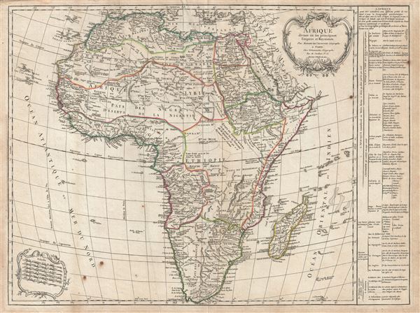
Afrique divisee en les principaux Empire et Royaumes.
1784 (undated) 20 x 26.5 in (50.8 x 67.31 cm) 1 : 37000000
1784 (undated) 20 x 26.5 in (50.8 x 67.31 cm) 1 : 37000000
Description
An exceptional 1784 map Africa by Robert de Vaugondy and Charles Delamarche. Following on the work of Nicolas Sanson, Vaugondy's map of Africa covers eth entire continent in considerable detail. The late 18th century saw little in the way of African Exploration, so other than some minor updates to South Africa, this issue, the first Delamarche state, remains consistent with the map originally published by Robert de Vaugondy in 1749.
Like most maps of Africa from this period, the while is rife with speculation. Vaugondy, unlike many of his contemporaries, attempts to limit his geographical analysis of the continent to those areas reported on in relatively recent times. Thus thus the White Nile, rather than turn east to meet with the Niger or flow south into the Ptolemaic Mountains of the Moon, merely tapers off into the unknown. Central Africa is largely left blank, although appears to be divided into several little known kingdoms: Monoemugi, Mujac, Gingir-Bomba, and Macoco, among others. The Sultanate of Zamziba is given control of much of Western Africa from the Horn to the Zambesee River. Lake Malawi appears in recognizable but embryonic form with it supper terminus left unmapped and thus unknown. In west Africa the known kingdoms of Benin and Congo are mapped according to the early 18th century conventions. South Africa exhibits updated information associated with mid-18th century discoveries.
Two rococo cartouches appear in the upper right and lower left quadrants. A statistical table appears to the right of te map proper.This is the 5th state of Robert de Vaugondy's Africa map and was issued for the 1784 Delamarche issue of the Atlas Universel.
CartographerS
Robert de Vaugondy (fl. c. 1716 - 1786) was French may publishing from run by brothers Gilles (1688 - 1766) and Didier (c. 1723 - 1786) Robert de Vaugondy. They were map publishers, engravers, and cartographers active in Paris during the mid-18th century. The father and son team were the inheritors to the important Nicolas Sanson (1600 - 1667) cartographic firm whose stock supplied much of their initial material. Graduating from Sanson's maps, Gilles, and more particularly Didier, began to produce their own substantial corpus. The Vaugondys were well-respected for the detail and accuracy of their maps, for which they capitalized on the resources of 18th-century Paris to compile the most accurate and fantasy-free maps possible. The Vaugondys compiled each map based on their own geographic knowledge, scholarly research, journals of contemporary explorers and missionaries, and direct astronomical observation. Moreover, unlike many cartographers of this period, they took pains to reference their sources. Nevertheless, even in 18th-century Paris, geographical knowledge was limited - especially regarding those unexplored portions of the world, including the poles, the Pacific Northwest of America, and the interiors of Africa, Australia, and South America. In these areas, the Vaugondys, like their rivals De L'Isle and Buache, must be considered speculative or positivist geographers. Speculative geography was a genre of mapmaking that evolved in Europe, particularly Paris, in the middle to late 18th century. Cartographers in this genre would fill in unknown lands with theories based on their knowledge of cartography, personal geographical theories, and often dubious primary source material gathered by explorers. This approach, which attempted to use the known to validate the unknown, naturally engendered rivalries. Vaugondy's feuds with other cartographers, most specifically Phillipe Buache, resulted in numerous conflicting papers presented before the Academie des Sciences, of which both were members. The era of speculative cartography effectively ended with the late 18th-century explorations of Captain Cook, Jean Francois de Galaup de La Perouse, and George Vancouver. After Didier died, his maps were acquired by Jean-Baptiste Fortin, who in 1787 sold them to Charles-François Delamarche (1740 - 1817). While Delamarche prospered from the Vaugondy maps, he defrauded Vaugondy's window Marie Louise Rosalie Dangy of her rightful inheritance and may even have killed her. More by this mapmaker...
Charles-François Delamarche (August 1740 - October 31, 1817) founded the important and prolific Paris-based Maison Delamarche map publishing firm in the late 18th century. A lawyer by trade, Delamarche entered the map business with the 1787 acquisition from Jean-Baptiste Fortin of Robert de Vaugondy's map plates and copyrights. Delamarche appears to have been of dubious moral character. In 1795, the widow of Didier Robert de Vaugondy, Marie Louise Rosalie Dangy, petitioned a public committee for 1500 livres, which should have been awarded to her deceased husband. However, Delamarche, proclaiming himself Vaugondy's heir, filed a simultaneous petition and walked away with the funds, most of which he was instructed to distribute to Robert de Vaugondy's widow and children. Just a few months later, however, Delamarche proclaimed Marie Dangy deceased, and it is highly unlikely that any funds found their way to Robert de Vaugondy's impoverished daughters. Nonetheless, where Robert de Vaugondy could barely make ends meet as a geographer, Delamarche prospered as a map publisher, acquiring most of the work of earlier generation cartographers Lattre, Bonne, Desnos, and Janvier, thus expanding significantly upon the Robert de Vaugondy stock. Charles Delamarche eventually passed control of the firm to his son Felix Delamarche (c. 1750 - c. 1850) and geographer Charles Dien (1809 - 1870). It was later passed on to Alexandre Delamarche, who revised and reissued several Delamarche publications in the mid-19th century. The firm continued to publish maps and globes until the middle part of the 19th century. Learn More...
Source
Delamarche, C. , Atlas Universel (Paris) 1784.
Condition
Very good. Minor toning. A couple of minor wormholes near centerfold.
References
Pedley, M. S., Bel et Utile, no. 424.5. Tooley, R.V., Collectors' Guide to Maps of the African Continent and Southern Africa, p. 93-94. Afriterra 875 (1749 edition).