
This item below is out of stock, but another example (left) is available. To view the available item, click "Details."
Details
1848 Levasseur Map of Senegal, Gambia and Madagascar
1848 (undated) $175.00
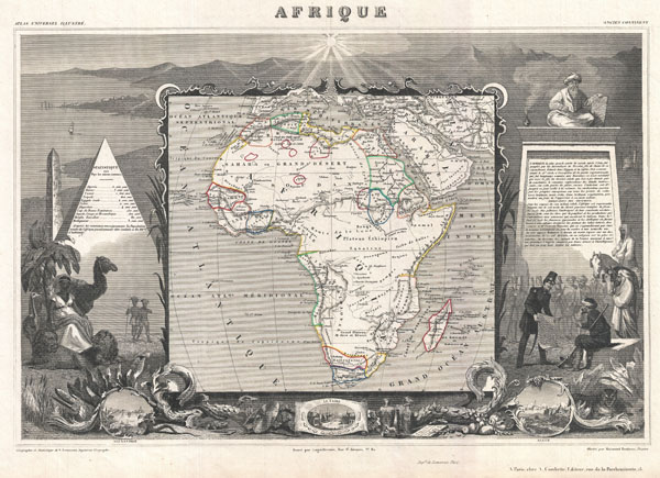
1852 Levasseur Map of Africa
Afrique-levasseur-1852$100.00

Title
Afrique.
1852 (undated) 12.75 x 17.5 in (32.385 x 44.45 cm)
1852 (undated) 12.75 x 17.5 in (32.385 x 44.45 cm)
Description
A fine example of V. Levasseur's desirable decorative map of Africa, dated 1852. Shows the entire continent according to perceptions of the time. Much of the interior is vague and unmapped, with the exception of the northern Nile Valley, the French colonies in Senegal, Gambia, and Algeria, and the colonies of the Dutch and English in South Africa. Offers a semi-accurate mapping of the Niger, which is uncommon for the period. Correctly identifies Lake Chad. The whole is surrounded by elaborate decorative engravings designed to illustrate both the natural beauty and trade richness of the land. These include the Pyramids, an seated Imam, the Luxor Obelisk, and views of Cairo, Alexandria, and Algiers. There is a short textual history of the regions depicted on both the left and right sides of the map. Published by V. Levasseur in the 1852 edition of his Atlas National de la France Illustree.
Cartographer
Victor Levasseur (1800 - 1870), an important French engineer, cartographer, and engraver of the mid 19th century, held a number of important cartographically related political and educations posts in France. He is most famous for his Atlas National Illustré des 86 Départements et des Possessions de La France, a large decorative atlas of France, including his Planisphere and five important continental maps. Levasseur's maps are distinctive for their wide decorative margins containing elaborate depictions of the scenery, peoples, and trade goods of the areas he mapped. Levasseur maps are also known to offer a wealth of statistical data. Until recently, very few Levasseur Atlases migrated out of France where they were mostly used in public libraries and town halls. His work represents some of the last great decorative atlases of the 19th century. More by this mapmaker...
Source
Levassuer, V., Atlas National Illustre des 86 Departements et des Possessions de La France Divise par Arrondissements, Cantons et Communea avec La Trace de Toutes Les Routes, Chemins,de fer et Canaux., 1852 edition.
Condition
Very good. Blank on verso. Wide clean margins.
References
Phillips (Atlases) 3003.