This item has been sold, but you can get on the Waitlist to be notified if another example becomes available, or purchase a digital scan.
1914 Ryozo Tanaka Serio-Comic Map of Europe and Asia (World War I)
AHumorosWarMap-tanaka-1914$3,250.00

Title
Kokkei Sensou Sekai Chizu. / Ahumoros Wap Map of the World. / 滑馨戰争世界地圖
1914 (dated) 18 x 23 in (45.72 x 58.42 cm)
1914 (dated) 18 x 23 in (45.72 x 58.42 cm)
Description
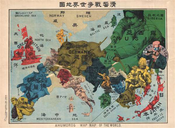
A very rare Japanese broadsheet serio-comic map of Europe and Asia drawn just following the outbreak of World War I. This map was drawn by Ryōzō Tanaka and published by the Shobido Company of Tokyo. The map covers all of Europe and parts of East Asia. All text is in both English and Japanese, clearly indicating that the audience for this map is not exclusively Japanese, but also potential allies in England and the United States.
The map conveys an interesting message that juxtaposes the conflict in Europe with troubles in East Asia and suggests a common cause between England and Japan. At center a threatening German bulldog wearing a spiked helmet crushes Belgium under its paw. Britain appears as a dreadnaught focusing its substantial firepower on Germany. This situation is mirrored in the lower right corner, where a curiously designed half-inset illustrates the East Asian theater. Here Germany, situated in its colonies around Tsingtao (Qingdao), known collectively as the Kiautschou Bay Concession, is again represented as a bulldog. Japan, like England, appears in Red, and is similarly focusing its military might and firepower on the German bulldog.
When War I in Europe Broke out on August 15, 1914, Japan delivered an ultimatum to Germany demanding that it relinquishe its control of the disputed territory of Kiaoutschou. Germany rejected the ultimatum and Japan declared war on August 23rd. The Japanese navy bombarded German Tsingtao and, on November of 1914, following the Siege of Tsingtao, Japanese forces occupied the region. On the present map Germans still controlled the concessions, but Japanese forces out of Port Arthur (Dalian) are clearly advancing.
Elsewhere on the map the United States, personified as Uncle Sam, observes both Europe (with binoculars) and Asia (with a telescope), interested in the conflict, but as yet unwilling to take a stand. France, like England, directs it firepower towards Germany while standing on the back of Spain. Switzerland, represented as a large child, covers its ears and puts its head down. Austria is directing its attention to enemies in Russia and Serbia. Russia, an enormous man filling the upper right corner, is fully occupied with Germany, and is trying to cut off its leg, possibly representative of attempts to seize East Prussia. China, shown as a great yellow general, rests his head in his hands, but still kicks at the German bulldog of Tsingtao. Italy, like the United States, watches.
This is the second of two serio-comic maps published in Japan to illustrate World War I, both by Tanaka. The first map, A Humoros Atlas of the World, focuses more on Russia and was published just a few days prior. Both maps are today exceedingly rare with no market history. The OCLC identifies only a single holding of this map at Brown University.
Cartographer
Ryōzō Tanaka (田中良三, January 16, 1874 - July 1, 1946) was a Japanese printer, publisher, illustrator, and bookseller active in Japan during the late 19th and first half of the 20th century. He was an important figure in the development of printing in 20th century Japan, including as part of the Shin-Hanga (新版画, 'new woodblock print') school, which revived traditional ukiyo-e techniques in the face of chromolithographic printing, which had become very popular in the late Meiji period. Tanaka was born in Kyoto, the second son of Haishi Hashimoto. He apprenticed under an Osaka bookseller Tanaka Jubei (田中重兵衛), marrying that individual's fourth daughter and taking the Tanaka name. Sometime in the 1890s, he relocated to Tokyo to open a branch office of the Tanaka Jubei firm. He soon thereafter (1897) opened his own business, the Tokyo Shobido Gakyou (東京尚美堂画局) book cart, in Kyobashi, Tokyo. It is said he started his book business with just 30 yen and 600 traditional ukiyo-e prints. By 1898, he acquired a physical location in the Kanda book district of Tokyo and began printing on his own account, pioneering Japanese chromolithography. Tanaka issued a series of serio-comic style maps in Japanese and English illustrating the events of World War I (1914 - 1818). In 1930, Tanaka shifted gears, becoming an adherent of the Shin-Hanga School and publishing some of its leading figures, including Hasui Kawase, Hiroaki Takahashi, and Mitsuitsu Tsuchiya. But he also continued to print and publish lithographic works, including a large number relating to Japan's military operations in China in the 1930s, the life of Japanese residents in China, and related matters. Most of Tanaka's original printing plates were destroyed in the March 1945 firebombing of Tokyo. After the war, Takaka's business was taken over by his eldest son, Tanaka Teizō (田中貞三), who attained some success. More by this mapmaker...
Condition
Very good. Minor margin repair and centerfold reinforcement.
References
OCLC 905547169.