
1945 942nd Aviation Topo. Bn. Map of Allied Airfield Development in Central Europe

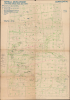
Airfield Development. Changes Since Nov. 30th 1944.
Airfields during the Allied advance west through Germany.
$750.00
Choose a Collection:
- Digital Map Information
- Suitable for large format printing
- Full resolution TIFF file
- ICC color profile embedded
- Delivered instantly via download link
This Item
Enquire
Airfields during the Allied advance west through Germany.
This is a February 1945 map of Central Europe detailing Allied airfield development between November 30, 1944, and the beginning of February 1945, during the Allied westward advance during World War II (1939 - 1945). The map is a key record of both the construction of Allied airfields and the appropriation of German fields as Allied-controlled territory expanded throughout the course of the war.A Closer Look
Airfields and landing grounds are marked using different circles to indicate the length of the runway (larger aircraft require longer runways). Blue circles mark airfields and landing grounds that became operational to Allied use from November 30, 1944 (likely when the last Airfield Development map was issued). Gray circles and names must mark German airfields that were operational at one point. Areas covered in green manuscript notations illustrate areas under Allied control. A note written in the same green in the left margin also references Airfield Regional Commands. Airfield Regional Commands are also listed in black pen in the left margin.Opportunities for Further Research
Several annotations are not clearly explained. One is the red manuscript circles that mark certain airfields. Perhaps these are airfields that are known to be options for emergency landings. Annotations executed in the same black pen that lists the Airfield Regional Commands in the left margin appear as boxes around city names with numbers and Roman numerals next to them. Other cities are underlined in this black pen.Publication History and Census
This map was issued on February 7, 1945, and printed by the 942nd Aviation Topographic Battalion not long after (possibly even the same day). It is likely that the 942nd also created it (since aviation topographic battalions were tasked with making maps for the U.S. Army Air Force), but there is no printed indication that this is the case. We have not located any other cataloged examples of this map or any similar map.Condition
Very good. Wear along original fold lines. Vero repairs to fold separations. Old tape on verso.