
1937 Boucher Pictorial Air France Route Map of the World


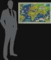
Air France Réseau Aérien Mondial.
Lucien Boucher limited edition.
$1,650.00
Choose a Collection:
- Digital Map Information
- Suitable for large format printing
- File Size: 152.06 MB
- File Type: ZIP / TIFF
- ICC color profile embedded
- Delivered instantly via download link
This Item
Enquire
Lucien Boucher limited edition.
This is a 1937 Lucien Boucher pictorial art-deco map of the world promoting the global routes of Air France. It is one of a sereis of iconic maps Boucher issued at the dawn of the Air Age.A Closer Look
Coverage is centered roughly on Paris but extends east and west to include all of Asia and Africa, as well as parts of North America, South America, and Australia. Bold red lines trace Air Frances's pioneering routes, particularly its coverage of South America, its proposed trans-Atlantic flight to New York, and its impressive routes to Southeast Asia, including stops in Bangkok, Saigon, Loung Prabang, and Hanoi.People and places are represented pictorially: the Arc de Triomphe marks Paris, skyscrapers identify New York, and a bagpiper appears near London. Monuments mark Budapest, Montevideo, and Baghdad, while stylized vignettes of local inhabitants decorate all five continents.
Publication History and Census
This map was drawn in 1937 by Lucien Boucher and published by Perceval in Paris for Air France. There were a total of 600 printed, all numbered. Numbers 1 to 250 were issued on Arches Paper, while the remaining sheets, from 251 to 600, were issued on Canson and Montgolfier Paper. The present example, no. 291, is part of this latter group. It is unclear how many have survived as this is one of Boucher's rarer Air France maps. We note two cataloged examples: the David Rumsey Map Collection and the National Air and Space Museum.Cartographer
Lucien Boucher (1889 - 1971) was French cartoonist, artist, writer, and illustrator. Boucher was born in Chartres in 1889 and graduated from the École de Céramique de Sèvres. His work as a cartoonist appeared in the humorous weekly Le Rire. Starting in the 1920s he produced numerous pictorial posters inspired by the commercial promise of surrealism. Among them were a series of surrealistic planispheric and celestial maps drawn to illustrate the transportation networks of Air France. Further Details...
Condition
Good. Mounted on heavy linen. A few old tears expertly repaired.
References
Rumsey 8571.000. National Air and Space Museum A19900479000.