This item has been sold, but you can get on the Waitlist to be notified if another example becomes available, or purchase a digital scan.
1798 Cassini Map of Alaska and the Bering Strait
Alaska-cassini-1798$625.00

Title
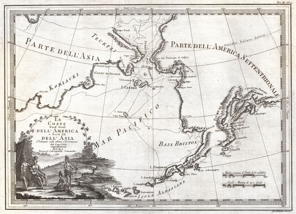
Le Coste Nord Ovest Dell' America e Nord Est Dell' Asia Delineate sulle ultime Osservazioni del Cp. Cook.
1798 (dated) 14.5 x 20 in (36.83 x 50.8 cm)
1798 (dated) 14.5 x 20 in (36.83 x 50.8 cm)
Description
An extraordinarily fine example of Cassini's 1798 map of Alaska, the Bering Strait, and Siberia. Cassini issued this map in his 1798 atlas to illustrate the discoveries made by James Cook. Cook was the first to accurately chart the Alaskan coastline and provide a detailed mapping of the Aleutian Islands. Cook's zigzagging route is shown as he skirts the Aleutian Islands, passes through the Bering Strait into the Arctic Ocean, and then turns back to sail south along the Siberian Coast. Here the Aleutians are collectively identified as 'Isole Alessiane,' though many of the original islands are clearly given indigenous names. A large decorative cartouche in the lower left depicts four American Indians and a baby. This is perhaps the most beautiful of the many maps designed to illustrate Cook's voyages. As a side note the condition of this particular example is phenomenal, the best we've seen, if you are considering adding this extremely scarce map to your collection, this is the one you want.
CartographerS
Giovanni Maria Cassini (1745 - 1824) was a Rome based Italian mathematician, globe maker, geographer, engraver, and cartographer active in the later part of the 18th and early 19th century. He was a disciple of Giovanni Battista Piranesi. He invented new form of projection used for an atlas of the kingdom of Naples issued by Giovanni Antonio Rizzi Zannoni. Cassini is best known as a globe maker and is considered the last of the great 18th century globe makers. His maps are distinctive for their fine engraving, dark strong impressions, and elaborate distinctive cartouche work. Unlike many map and atlas publishers of the period, Cassini did all of his own engraving work - this impregnating each map with his unmistakable style. Though he produced a significant corpus of well-regarded work, little is known of Cassini's personal life. G. M. Cassini is often mistakenly associated with the well-known French cartographic family of the same name, however, they are not related. More by this mapmaker...
Captain James Cook (7 November 1728 - 14 February 1779) is a seminal figure in the history of cartography for which we can offer only a cursory treatment here. Cook began sailing as a teenager in the British Merchant Navy before joining the Royal Navy in 1755. He was posted in America for a time where he worked Samuel Holland, William Bligh, and others in the mapping of the St. Lawrence River and Newfoundland. In 1766 Cook was commissioned to explore the Pacific and given a Captaincy with command of the Endeavour. What followed were three historic voyages of discovery, the highlights of which include the first European contact with eastern Australia, the discovery of the Hawaiian Islands (among many other Polynesian groups), the first circumnavigation of New Zealand, some of the first sightings of Antarctica, the first accurate mapping of the Pacific Northwest, and ultimately his own untimely death at the hands of angry Hawaiians in 1779. The influence of Cook work on the mapping and exploration of the Pacific cannot be understated. Learn More...
Source
Cassini, Giovanni Maria, Nuovo Atlante Geografico Universale Delineato Sulle Ultime Osservazioni, V. 3, Rome: Calcogrfia camerale, 1798.
Condition
An extremely fine example - the best we have seen. Original centerfold. Wide clean margins. Original pressmark visible. Blank on verso.
References
Falk, M., Alaskan maps : a cartobibliography of Alaska to 1900, 1798-1, 1791-81, p. 72. University of Washington Libraries, Rare Map Collection. G9236 S12 1798 Z3.