This item has been sold, but you can get on the Waitlist to be notified if another example becomes available, or purchase a digital scan.
1942 Nelson and Minneapolis Sunday Tribune Map of Alaska and North Pole
Alaska-nelson-1942$175.00

Title
Alaska: Springboard for Our Attack Upon Japan!
1942 (dated) 21 x 15 in (53.34 x 38.1 cm)
1942 (dated) 21 x 15 in (53.34 x 38.1 cm)
Description
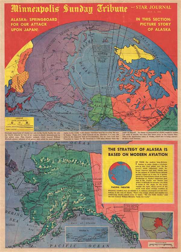
This is a Warner S. Nelson and Minneapolis Sunday Tribune and Star Journal front page with two maps printed on it from July 5, 1942. The top map depicts a polar map of the North Pole, illustrating Asia and North America, labeling the U.S.S.R., Mongolia, China, and Manchukuo in Asia and Alaska, Canada, and the United States in North America. Meant to explain the strategic importance of Alaska in the current war (World War II), air routes from Anchorage are illustrated to Moscow, Berlin, Rome, London, Los Angeles, Tokyo, Vladivostok, Minneapolis, and New York. The summer aid route from Seattle to Archangel is illustrated in red. The caption informs the reader that Alaska is 1700 miles closer to Japan by air than Hawaii, and that it is only 750 miles by air from Seattle – less than four hours by bomber, per the caption. These distances reflect Alaska's importance in America's war, and why it is 'being converted into a vast fortress.'
The bottom map is a specific map of Alaska. This map depicts the region from Asia (Russia – U.S.S.R.) to the Klondike and from the Arctic Ocean to the Pacific Ocean. Numerous locations throughout Alaska are labeled, including Anchorage, Juneau, Seward, and Point Barrow. The Brooks Range, the Alaska Range, the Sischu Mountains, and the Cugach Mountains are also labeled. Several text boxes inform the Sunday Tribune's readers about the importance of Alaska, such as that it contains the only tin deposits in the United States and that forests on the Alaska panhandle could supply one quarter of the United States' newsprint perpetually. A text box, entitled, 'The Strategy of Alaska is Based on Modern Aviation' discusses the concept of the 'great circle' routes in aviation and that arctic air travel routes are shorter due to the 'tight, sharp curves of the Earth' closer to the pole. A small inset map superimposes Alaska over the continental United States, providing an idea of the relative size of the state versus the continental U.S.
These two maps were created by Warner S. Nelson of the Minneapolis Star and printed by the Minneapolis Sunday Tribune and Star Journal on July 5, 1942.
Cartographer
The Minneapolis Tribune (1867 - present) was founded by Colonel William S. King, William D. Washburn, and Dorilus Morrison and the first issue was published on May 25, 1867. In 1941, the Cowles family of Des Moines, Iowa bought the Tribune and merged it with their other holdings in Minneapolis, giving the Cowles family ownership of all the city's major newspapers. The Tribune became the city's morning newspaper, and the Star-Journal was the evening newspaper. The two published a joint Sunday edition. The newspaper is still published today, under the name Star Tribune. More by this mapmaker...
Condition
Good. Newsprint. Wear along original centerfold. Even overall toning. Closed tear extending 1.25 inches in center professionally repaired on verso. Closed margin tears professionally repaired on verso. Printed photographs and text on verso.