
This item below is out of stock, but another example (left) is available. To view the available item, click "Details."
Details
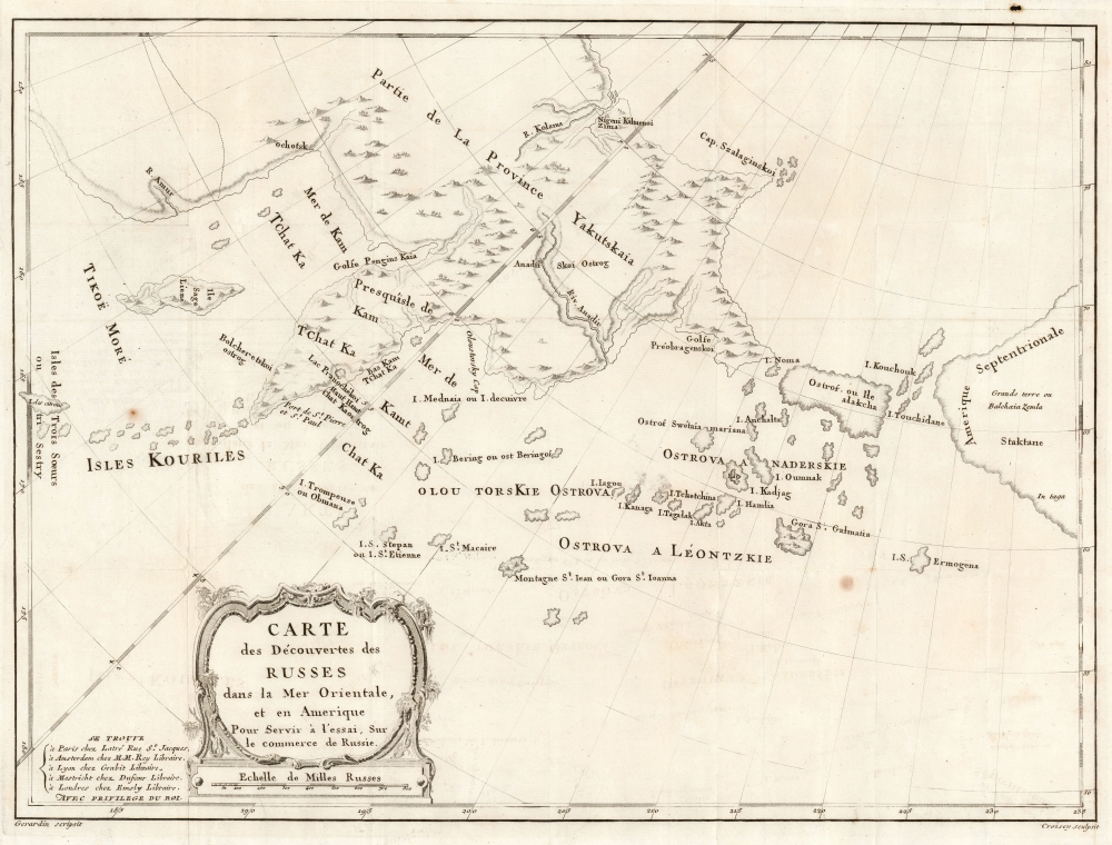
1777 Croisey Map of the Russian Discoveries in Alaska and Bering Strait
$2,000.00
1777 Croisey Map of the Russian Discoveries in Alaska and Bering Strait
AlaskaSiberia-croisey-1777-2$1,000.00

Title
Carte des Découvertes des Russes dans la Mer Orientale, et en Amerique Pour Servir à L'essai, Sur le commerce de Russie.
1777 (undated) 16 x 21.75 in (40.64 x 55.245 cm) 1 : 10000000
1777 (undated) 16 x 21.75 in (40.64 x 55.245 cm) 1 : 10000000
Description
This is a rare and unusual 1777 map of the North Pacific in the vicinity of Alaska, the Bering Strait, and northeastern Siberia based upon Russian Promyshlenniki (trader) exploration. It appeared accompanying one of the earliest works on Russian commerce, the M. de Marbault's Essai sur le Commerce de Russie, avec l'Histoire de ses Decouvertes.
Sources
Marbault's precise sources are obscure, but he was in Russia while preparing his work serving as secretary to Durand, then minister of France in Russia, and thus may have had direct access to Russian geographical sources and traders. The map post-dates the Russian state-sponsored Great Northern Expedition of Vitus Bering (1733 - 1743) but pre-dates the English voyages of Captain James Cook, who definitively remapped the Pacific Northwest on his third and final voyage (1776 - 1779). Bering's Great Northern Expedition focused Russian attention on the potential resources and wealth of northeast Siberia and, presumably, the northwesternmost extremes of America.Entering A Confused Field
With Bering's new knowledge of some of the Aleutian Islands and potential easy access to American shores from Siberia, Russian Promyshlenniki fur traders eager for new richer sources of sable, otter, and seal furs launched a series of commercial expeditions from the coast of Kamchatka. Their efforts resulted in a confused array of maps of the Aleutian Islands and the American coast based on a combination of unscientific mapping and flawed interpretations of Inuit cartographic knowledge. The most important of these was the secret expedition of Ivan Synd, whose (now lost) cartography caused Gerhard Muller to redraw his important map of 1758. The second state of Muller's map, issued in 1773, replaces his iconic peninsula with a series of islands - as reported by Synd, including the island of 'Alakcha' - marking some of the earliest usage of that term, an Aleut word meaning 'big island' or possibly 'mainland.'A Fresh Approach
Although the map here clearly owes some debt to Muller's second map, particularly in the treatment of the American mainland and the shape of the islands of 'Alakcha,' it is far from a slavish copy and the nomenclature employed suggests the author had access to additional Russian source material. The proto-Aleutian Islands south of 'Alakcha' island appear unrelated in form, nomenclature, and situation to any previous known work, including that of Muller and may reference lost Synd cartography, Andrean Tolktykh's expedition, the explorations Petr Krenitsyn and Mikhail Levashev, or possibly even other lesser known Promyshlenniki literature. Certainly, much of the nomenclature is derived directly from Krenitsyn and Levashev, and given the secretive nature of this voyage, it is remarkable that their nomenclature found its way into Marbault's work.Publication History and Census
This map was engraved by Jean-Baptiste Croisey to illustrate Marbault's, Essai sur le Commerce de Russie, avec l'Histoire de ses Decouvertes, issued in Amsterdam in 1777. The book is well-represented in institutional collections. We see the separate map listed only twice in OCLC, by the University of British Columbia and the National Library of Scotland.Cartographer
Jean-Baptiste Croisey (c. 1740 - 1810) was a French Paris based engraver active from roughly 1760 through 1810. Little is known of his life and training. His earliest known work was for Jacques-Nicolas Bellin (1703 - 1772), chief Ingénieur Hydrographe at the French Dépôt des cartes et plans de la Marine until 1798. He also engraved for Louis Charles Desnos (1725 - 1805) from 1790 to 1792, and for Bruny d'Entrecasteaux in 1807, among other publishers. More by this mapmaker...
Source
Marbault, M. de, Essai sur Le Commerce de Russie, avec L'Histoire de ses Découvertes, (Amsterdam) 1777.
Condition
Very good. Minor repairs and reinforcements on verso Original fold lines. Margins narrow.
References
OCLC 316508971.