This item has been sold, but you can get on the Waitlist to be notified if another example becomes available, or purchase a digital scan.
1689 Cantelli / De Rossi Map of Albania
Albania-cantellirossi-1689$1,000.00

Title
Albania Propria overo Superiore detta anche Macedonia Occidentale descritta, con Disegni fatti sul luogo. . .
1689 (dated) 21.25 x 16.75 in (53.975 x 42.545 cm) 1 : 830000
1689 (dated) 21.25 x 16.75 in (53.975 x 42.545 cm) 1 : 830000
Description
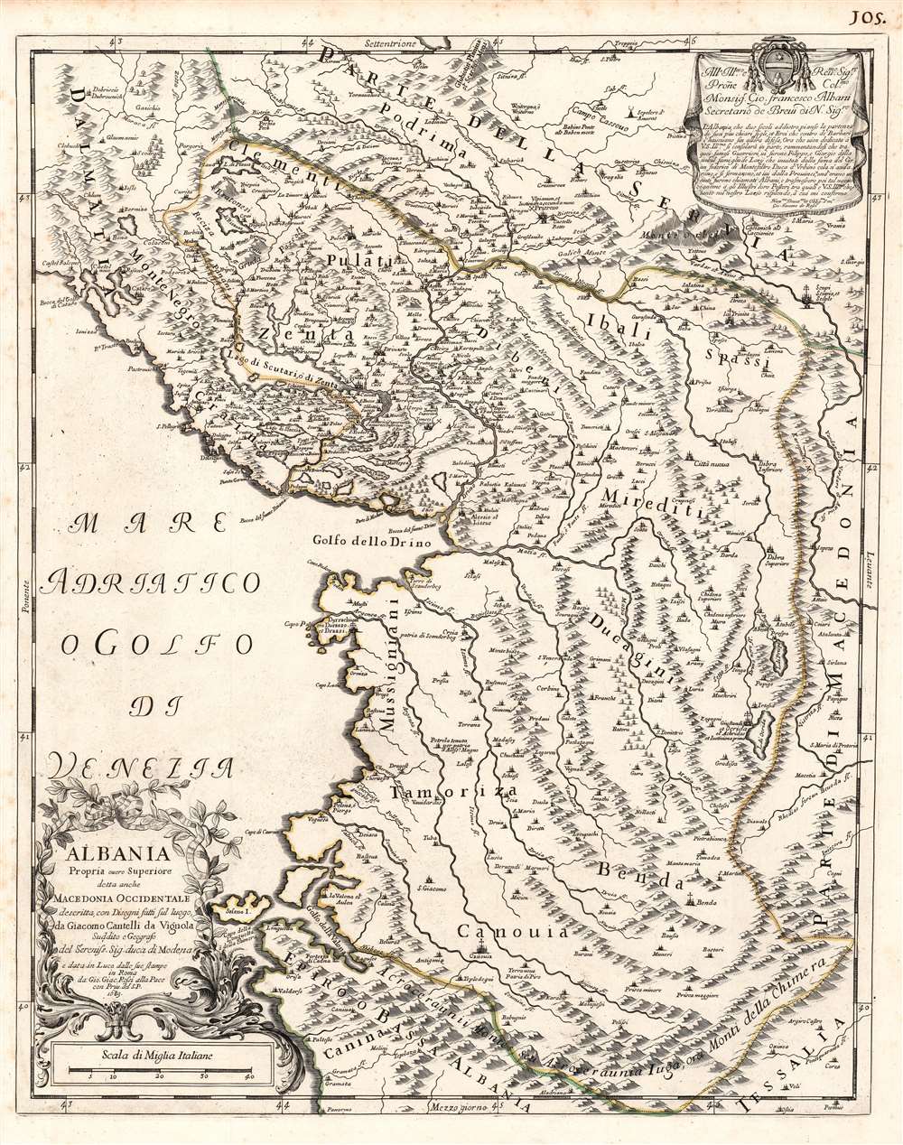
This is a rare 1689 Cantelli da Vignola map of Albania - the first reasonably accurate printed map of Albania. The map incorporates most of modern-day Montenegro and part of Macedonia. This is the only specific map of Albania produced in the 17th century, predated only by the 1572 Camocio map. Lissus on the coast corresponds with modern Lezhë at the mouth of the Drin. The modern capital of Tirana appears here as Terrana. The city of Vlorë appears, using its Italian name Valona (and the Greek Aulon.) To the southwest of Terrana is noted Petrela, a supposed birthplace of Alexander the Great. The mountainous terrain is pictorially depicted, showing in particular the forbidding mountain ranges forming the country's natural borders with Greece, Macedonia, and Kosovo.
The map includes most of Montenegro as well, showing the lakes of Shkodra, Krupac and Slansko (these latter seem to correspond with Plava and Ricavez on the map.) The ancient lakes Ohrid and Prespa are both shown - small, as compared to their actual state, and puzzlingly transposed, with Prespa to the north of Ohrid. Also, both are shown flowing into the Black Drin River (In reality, only the Ohrid does so: Prespa drains into Ohrid via underground watercourses.)
The Engraving
Cantelli’s maps, notably their cartouches, were some of the most attractively engraved of the later 17th century. The present, superbly executed copperplate engraving exhibits neatly hachured coastlines, pictorially represented mountains and forests, and clear, elegant, typography. A ribboned laurel cartouche appears in the Adriatic to the lower left. In the upper right is a dedicatory cartouche to the Papal official Giovanni Francesco Albani. who in 1700 would become Pope Clement XI. The Albani family, which had Albanian origins, had long been powerful and influential in the Church: Giovanni Francesco was not the first Albani to be Pope.The map includes most of Montenegro as well, showing the lakes of Shkodra, Krupac and Slansko (these latter seem to correspond with Plava and Ricavez on the map.) The ancient lakes Ohrid and Prespa are both shown - small, as compared to their actual state, and puzzlingly transposed, with Prespa to the north of Ohrid. Also, both are shown flowing into the Black Drin River (In reality, only the Ohrid does so: Prespa drains into Ohrid via underground watercourses.)
Publication History and Census
This map was drawn by Cantelli, and engraved in Rome by Giorgio Widman for De Rossi's publishing house. It was printed for inclusion in De Rossi's Mercurio Geografico in 1689. We count fifteen examples of the Mercurio Geografico in institutional collections. The separate map appears catalogued only in four copies: by the Bibliotheque National de France, the Biblioteca Nacional de Espana, the Bayerische Staatsbibliothek and Harvard University.CartographerS
Giovanni Giacomo de Rossi (1627 - 1691) was an Italian engraver and printer, active in Rome during the second half of the 17th century. His father, Giuseppe de Rossi (1570 - 1639), was the founder of the most important and active printing press of the 17th century in Rome. The printing press was begun in 1633, by Giuseppe de Rossi, and it passed firstly to Giovanni Giacomo and to his brother Giandomenico (1619 - 1653), and then later to Lorenzo Filippo (1682-?), then Domenico de Rossi (1659 - 1730). Giovanni Giacomo de Rossi was most active between 1638 and 1691 and was to take the company to the height of its success. The artists that he printed the etchings for included Giovanni Benedetto Castiglione (1609 - 1665), Pietro Testa (1612-1650), and Giovan Francesco Grimaldi (1606 – 1680). Cartographically he is best known for producing the maps of Giacomo Cantelli da Vignola and publishing them in his c. 1683 Mercurio Geografico. In 1738 the firm became the Calcografia Camerale, from 1870 until 1945 the Regia Calcografica, and today it is known as the Calcografia Nazionale. The Calcografia Nazionale holds is one of the finest collections of early printing plates and prints in the world. More by this mapmaker...
Giacomo Cantelli da Vignola (February 22, 1643 - November 30, 1695) was an important Italian cartographer and engraver active in 17th century Italy. Cantelli was born in Montorsello, near Vignola, Italy to a prominent local family. After studying literature at the University of Bologna, Cantelli took a position as secretary to the Marquis Obizzi de Ferrara. Eventually Cantelli relocated to Venice where he developed an interest in cartography. He later traveled to Paris in the company of the French ambassador where became acquainted with the French cartographer Guillaume Sanson, as well as his contemporaries Jacques-Andre Duval and Michel-Antoin Baudrand. It was most likely the influence of these innovative French cartographers that inspired Cantelli's careful and meticulous approach, in which he based his cartography not just on earlier maps, but also very much in the French style upon accounts written by travelers and merchants regarding actual travel to foreign lands. Back in Italy, Cantelli took service with Count Rinieri Marescotti, with whom he traveled extensively throughout Italy, becoming in the process acquainted with the Italian publisher Giovanni Giacomo de Rossi. It is with Rossi that Cantelli began officially publishing his maps. The earliest maps to bear the Cantelli-Rossi imprint date to 1672 and detail the Holy Land, Persia, and the Ottoman Empire. Around 1680 the duo also began to publish the Mercurio Geografico, a large format atlas illustrating all parts of the world in a splendid Italian baroque detail defined by elaborate finely engraved cartouche work, high quality paper, bold Roman lettering, and dark rich inks. Some have compared his style go that of Giovanni Antonio Magini, another Italian cartographer of the previous generation. Cantelli da Vignola in fact pioneered the Italian style of fine bold engraving that would eventually be embraced and expanded upon by Vincenzo Coronelli. His work drew the attention of Pope Innocent XI and Reggio Francesco II d'Este, the Duke of Modena, both of whom offered him a position as court geographer. Cantelli chose to work with the Duke of Modena, in the service of whom he produced numerous maps and well as two large globes. He died in Modena in November 1695. Learn More...
Source
Rossi, G. G., Mercurio Geografico, (Rome) 1689.
Condition
Excellent. One marginal mend not impacting image. Else fine with an incomparable strike, and original outline color.
References
OCLC 494419700. Rumsey, 11438.143.