
Rossi, Giovanni Giacomo de

Giovanni Giacomo de Rossi (1627 - 1691) was an Italian engraver and printer, active in Rome during the second half of the 17th century. His father, Giuseppe de Rossi (1570 - 1639), was the founder of the most important and active printing press of the 17th century in Rome. The printing press was begun in 1633, by Giuseppe de Rossi, and it passed firstly to Giovanni Giacomo and to his brother Giandomenico (1619 - 1653), and then later to Lorenzo Filippo (1682-?), then Domenico de Rossi (1659 - 1730). Giovanni Giacomo de Rossi was most active between 1638 and 1691 and was to take the company to the height of its success. The artists that he printed the etchings for included Giovanni Benedetto Castiglione (1609 - 1665), Pietro Testa (1612-1650), and Giovan Francesco Grimaldi (1606 – 1680). Cartographically he is best known for producing the maps of Giacomo Cantelli da Vignola and publishing them in his c. 1683 Mercurio Geografico. In 1738 the firm became the Calcografia Camerale, from 1870 until 1945 the Regia Calcografica, and today it is known as the Calcografia Nazionale. The Calcografia Nazionale holds is one of the finest collections of early printing plates and prints in the world.
Scarce and Elegantly-Engraved Map of the Far East.

Il Regno Della China detto presentemente Catay e Mangin diviso sopra le Carte piú esatte sue Principali Provincie.
$2,200.00
Acquire
- Digital Map Information
- Suitable for large format printing
- DPI: 600
- File Size: 48.62 MB
- File Type: ZIP / TIFF
- ICC color profile embedded
- Delivered instantly via download link
This is a scarce 1682 Cantelli da Vignola map of China, Japan, and Korea, presenting a striking and up-to-date view of the Far East benefitting from Jesuit and Dutch reports. Its framework is derived from the 1552 Martino Martini map by Blaeu, but this map is significantly updated after the reports of the Jesuits Bento de Góis and Johann Grueber. (more details)
Strikingly decorative map of the East Indies, Philippines, and Australia.
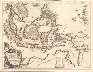
Isole dell'India cio è le Molucche, le Filippine e della Sonda, parte de paesi di nuova scoperta e l'isole de Ladri nel mare del zud / descritte da Giacomo Cantelli de Vignola ; Fran. Donia Messis sculp.
$1,500.00
Acquire
- Digital Map Information
- Suitable for large format printing
- File Size: 18.9 MB
- File Type: ZIP / TIFF
- ICC color profile embedded
- Delivered instantly via download link
A rare, highly decorative 1683 map of Southeast Asia and the East Indies by Giacomo Cantelli da Vignola and Giacomo de Rossi. (more details)
Crimea and Caucasus of the 17th century.
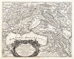
Tartaria d'Europa o vero Piccola Tartaria divisa da Giacomo Cantelli da Vignola ne Tartari Nogai e del Crim, o di Precop Soggetti al proprio Kam ne Tartari di Budziack, d'Oczackow, e di Dobruss, soggetti al Turco, ne Tartari Circassi, e di Mordua Soggetti al Gran Duca di Moscovia e nelle Due Uckraine...
$1,200.00
Acquire
- Digital Map Information
- Suitable for large format printing
- DPI: 600
- File Size: 68.61 MB
- File Type: ZIP / TIFF
- ICC color profile embedded
- Delivered instantly via download link
This is a 1684 Cantelli da Vignola map of the Caucasus, the lands of the Circassian and Crimean Tartars, Georgia, and Ukraine. The region - peopled by an array of Tatar and Cossack tribes - was largely under the domination of the Crimean Khanate and the Nogai Horde, but represented a borderland contested by the Grand Duchy of Muscovy and the Turkish Empire. (more details)
Finely engraved double hemisphere celestial chart.
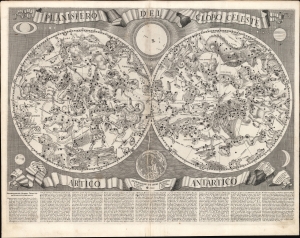
Planisfero del Globo Celeste Artico Antartico.
$3,000.00
Acquire
- Digital Map Information
- Suitable for large format printing
- File Size: 29.82 MB
- File Type: ZIP / TIFF
- ICC color profile embedded
- Delivered instantly via download link
An intricately engraved 1687 double hemisphere celestial chart prepared by Francesco Brunacci for inclusion in Giacomo Giovanni Rossi's atlas Mercurio Geografico, overo Guida Geografica in tutte le parti del Mondo, one of the most beautiful Italian atlases of the 17th century.. (more details)
Revealing Central Asia.
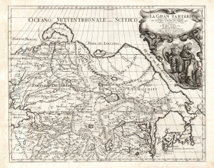
La Gran Tartaria.
$650.00
Acquire
- Digital Map Information
- Suitable for large format printing
- DPI: 600
- File Size: 55.88 MB
- File Type: ZIP / TIFF
- ICC color profile embedded
- Delivered instantly via download link
This is Cantelli da Vignola's 1693 map of Central and northeastern Asia, focusing on 'Tartar lands', an expansive territory spanning from the Russian steppe to the Great Wall of China. (more details)