1908 Cendoya y Busquets Map of the Alhambra, Granada, Spain
Alhambra-busquets-1908$150.00

Title
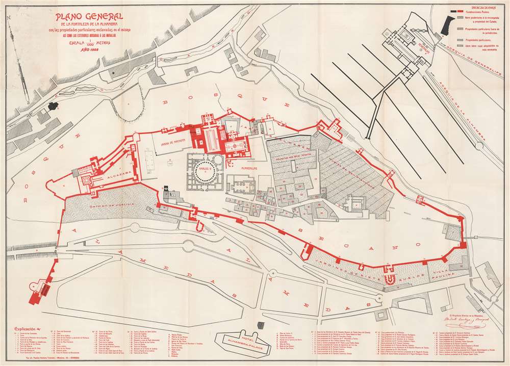
Plano General de la Fortaleza de la Alhambra con las propiedades particulares enclavadas en el mismo así como las exteriores adosadas á las murallas.
1908 (dated) 25.25 x 35.25 in (64.135 x 89.535 cm) 1 : 1000
1908 (dated) 25.25 x 35.25 in (64.135 x 89.535 cm) 1 : 1000
Description
This is a 1908 Modesto Cendoya y Busquets map of the Alhambra, Granada, Spain. Three indexes identify locations around the palace / fortress. One identifies towers, gates, and other places along the Alhambra's extensive walls and the second uses letters to mark major buildings within the complex. The third index, also numerical, labels rooms and smaller buildings. Buildings colored red and solid black were built by the Arabs when they ruled southern Spain. However, some buildings were built after the Reconquista, when the building was used as a palace by Christian kings.
The Alhambra
The first references to an Alhambra, or red castle, appeared during the rule of Abdullah ibn Muhammad (r. 888 - 912) in lines of poetry. Centuries passed before the Alhambra resurfaced in the eleventh century, when it was rebuilt by a vizier to the emir of the Zirid Dynasty. The Alhambra was completed near the end of Muslim rule in Spain during the reigns of Yusuf I (1333 - 1353) and Muhammad V (1353 - 1391). During the Nasrid period, when Sultan Ibn Nasr lived in the Alhambra, he began expanding the complex. His successors turned the fortress into a palace city, complete with gardens and several palaces. After the Reconquista in 1492, King Ferdinand II of Aragon and Queen Isabella I of Castile took up residence in the Alhambra, where they welcomed Christopher Columbus and decided to fund his quest across the Atlantic. Today, the Alhambra is one of Spain's most visited tourist sites and is a UNESCO World Heritage Site.Publication History and Census
This map was created and published by Modesto Cendoya y Busquets in 1908 and lithographed by Paulino Ventura Traveset. We note a single cataloged example in OCLC, located at the Biblioteca Nactional de España.Cartographer
Modesto Tiburcio Cendoya y Busquets (November 4, 1856 - September 26, 1938) was a Spanish architect and the director of La Alhambra from 1907 until 1923. Born in Bera, Spain, he studied at the Central Univeristy Falculty of Sciences in Madrid from 1870 until 1874. In 1885 he graduated from the Madrid Higher School with a degree in architecture. Cendoya y Busquets moved to Granada in 1885 to work on reconstruction efforts in towns destroyed by the Alhama earthquake. He was named municipal architect of Granada in 1888 and held the position until he retired in 1927. Over the course of his career, Cendoya y Busquets worked on numerous projects in the area, including the layout for the Gran Vía de Colón (1891), the Alhambra Palace Hotel, and the Spanish pavilion for the 1910 Universal Exhibition in Brussels, for which he won two awards. He was appointed Director of the Alhambra by Royal Order on May 1, 1907. He held this position until he was dismissed in 1923. Cendoya y Busquets' tenure as Director of the Alhambra is remembered as one of the most controversial in the modern era and he was dismissed because of accusations of laziness (supposedly driven by differences with the Board of Directors) and because he was said to be the cause of numerous and irreparable archaeological damage. More by this mapmaker...
Condition
Good. Exhibits wear and reinforcements where originally attached to binder. Verso repairs to fold separations.
References
OCLC 431751055.