This item has been sold, but you can get on the Waitlist to be notified if another example becomes available, or purchase a digital scan.
1805 Harris Map of the Allegheny, Monongahela, and Yohiogany Rivers
AlleghanyMonongahela-harris-1805$475.00

Title
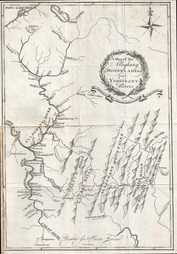
A Map of the Alleghany Monongahela and Yohiogany Rivers.
1805 (undated) 13 x 9 in (33.02 x 22.86 cm) 1 : 1031000
1805 (undated) 13 x 9 in (33.02 x 22.86 cm) 1 : 1031000
Description
This is an extremely scarce 1805 Thaddeus Mason Harris map of his journey through the region surrounding the confluence of the Alleghany and Monongahela Rivers at Pittsburgh (Pittsburg), Pennsylvania. The map depicts the region from the Ohio River to Strasburg, Pennsylvania and from Lake Erie to Morgantown, West Virginia. Focusing on the river system, villages, towns, and cities along the Alleghany, Monongahela, and Yohiogany (Yough / Youghiogheny River) are labeled. Creeks and streams running into these three rivers are illustrated and most are labeled. Fort Cumberland, Fort Fayette are labeled. The series of ridges and hills surrounding the Allegheny (Alleghany) Mountains are depicted.
Several of the locations recounted in the journal portion of Harris's book, The Journal of a Tour into the Territory Northwest of the Alleghany Mountains, are illustrated here. He discusses the difficulties in crossing the Juniata River, and stopping at Bedford to have their carriage repaired. He describes the crossing of the Monongahela at Elizabethtown, and includes a lengthy description of the river and the towns situated along its course, including Morgantown, Greensburg, Fredericktown, Bridgeport, and Brownsville, all of which are labeled on the map. 'Burt Cabins' appear in the Sideling Hills. Then, the following journal entry describes Pittsburgh, Fort Fayette (which lies within the town of Pittsburgh, and the continuation of their journey. Thus, the dotted line through Berlin and Elizabethtown that is present on this map illustrates Harris's trip to Marietta, Ohio, and the other dotted line, through Brownsville and Union, represents the return journey to Boston. The title is in a wreath-style cartouche with ribbon below containing the Latin phrase Flumina Amen Sylvasque Inglorius or 'May I love the rivers and forests without fanfare.'
This map was engraved by Thomas Wightman and published by Thaddeus Mason Harris in his book The Journal of a Tour into the Territory Northwest of the Alleghany Mountains… in 1805.
Cartographer
Thaddeus Mason Harris (July 7, 1768 - April 3, 1842) was a Harvard librarian, Unitarian minister and author. He was born in Charlestown, Massachusetts. After his father’s death while fighting on the colonial side in the American Revolutionary War, Harris was sent to live on a farm in Sterling, Massachusetts. Harris studied at Harvard University and graduated in 1787. Following his graduation, Harris spent a year as a school teacher in Worcester, Massachusetts, after which he was offered an appointment as secretary to George Washington. Unfortunately he contracted small-pox, and his lengthly recovery prevented him from taking the post. In 1791, Harris became the librarian at Harvard and was appointed as the minister of the First Unitarian Church on Meeting House Hill in Dorchester, Massachusetts, in 1793. In 1806, he was elected as a Fellow of the American Academy of Arts and Sciences and was also a founding member of the American Antiquarian Society in 1812. He served as corresponding secretary for the Antiquarian Society from 1812-1831, and as secretary of foreign correspondence from 1831-1832. More by this mapmaker...
Source
Harris, T.M., The Journal of a Tour into the Territory Northwest of the Alleghany Mountains; Made in the Spring of the Year 1803. With a Geographical and Historical Account of the State of Ohio., (Boston: Manning and Loring) 1805.
The Journal of a Tour into the Territory Northwest of the Alleghany Mountains; Made in the Spring of the Year 1803. With a Geographical and Historical Account of the State of Ohio. by Thaddeus Mason Harris, published in 1805, presents a history of Harris’s journey to Marietta, Ohio. The first section of the book consists of Harris’s journal, which is divided into two sections: the trip to Marietta, and the return trip to Boston. The second section, entitled, ‘Geographical and Historical Account of the State of Ohio’, was compiled by Harris. It includes a discussion of the state’s boundaries, its climate, minerals, rivers, fish, counties and towns, exports, antiquities, ‘curiosities’, government and history. In the chapter discussing Ohio’s history, a lengthy discussion of the Ohio Company is included. The final section is an appendix, which includes information about navigating the Ohio River and reprinted versions of a number of documents concerning the early history of Ohio, including the 1785 Land Ordinance, the contract between the Ohio Company and the U.S. Government for the sale of millions of acres of land (1787), the Northwest Ordinance (1787), the Congressional act enabling the establishment of Ohio (1802) and the Ohio Constitution (1802).
Condition
Very good. Wear along original fold lines. Verso repair of fold separation. Margin repair to left side. Professional repair along original centerfold. Blank on verso.