This item has been sold, but you can get on the Waitlist to be notified if another example becomes available, or purchase a digital scan.
1779 Sartine Map of Amelia Island, Florida
AmeliaIsland-sartine-1779$1,975.00

Title
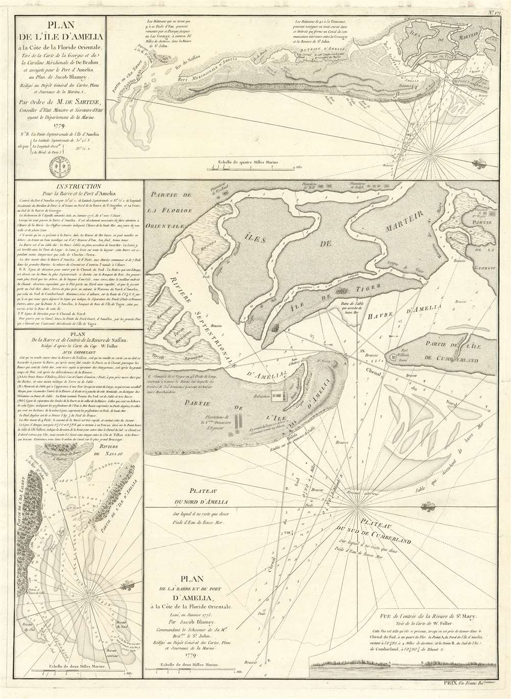
Plan de l'île d'Amelia à la Côte de la Floride Orientale. / Plan de la Barre et et de l'entrée de la Riviere de Nassau. / Plan de la Barre et du port d'Amelia, à la Côte de la Floride Orientale.
1779 (dated) 24.5 x 18 in (62.23 x 45.72 cm)
1779 (dated) 24.5 x 18 in (62.23 x 45.72 cm)
Description
This is a rare 1779 American Revolutionary War map of Amelia Island, Florida, issued by Antoine de Sartine (1729 - 1801) and Jean-Nicholas Buache de Neuville (1741 - 1825). The chart was issued following the 1778 Treaty of Alliance, in which France formally recognized the United States and offered to aid the fledgling country against the British. Early in the war, French aid was primarily maritime, so the Depot de Marine recognized the need for better nautical charts and began to compile and improve British charts of the North American coastline.
The Main Map
The present map essentially combines three earlier British charts, although in this case, the French charts are mildly improved and more finely engraved. The main chart, occupying the lower right two-thirds of the map, is oriented to the east and covers the northern part of Amelia Island as well as the southern part of Cumberland Island where the ruins of Oglethorpe's Fort William are noted. It also notes Mount Misery, and the 'Habitation', essentially a manor house and outbuildings designed to manage the Dowager Egmont's large indigo plantations noted further south - the subsequent location of Fernandina. On the Florida mainland the plantations of Woodland, Bell, Wright, and Ralph are identified. In the lower right there is a coastal view illustrating the entrance to the Saint Mary River, the Georgia-Florida border. Cartographically this map is derived from Jacob Blamey's map of 1775, published by Sayer and Bennett.The General Map
The second map, both in terms size and significance, appears at top right and covers all of Amelia Island and parts of Talbot Island, the entrance to the Nassau River, and southern Cumberland island. It is derived from the seminal 1757 John William Gerard De Brahm (1717-1798) mapping of the South Carolina coast. Although it overlaps somewhat with the more specific map below, it offers a valuable general reconnaissance of the region.The Nassau River
The third map, appearing in the lower left corner, focusses specifically on the western part Amelia Island, Talbot Island, and the entrance to the Nassau River - an important artery for navigators. The map, derived from the 1770 work of Captain William Fuller, is oriented to the northeast and features numerous soundings and details of significance to the mariner.The Egmont Plantation
John Perceval, 2nd Earl of Egmont, received an expansive grant on Amelia island in 1763, when Spain ceded Florida to England in exchange of Havana, which had been seized on year earlier in 1762, during the Seven Years War. The grant, encompassing some 10,000 acres, the entire island, was ideally suited for the cultivation of cotton and indigo. Egmont himself never visited the Americas, but under supervision of the experienced planter Stephen Egan, the East Florida plantation prospered. When Egmont died in 1770, the plantation continued to be managed by his widow, Catherine Perceval (1731-1784), the Dowager Earless and Baroness Arden. During the American Revolutionary War, the lucrative estate was plundered and destroyed by Georgia Militia, causing Egan to flee with his family and the Egmont slaves. When this map was made, the island was, for the most part, abandoned, but the ruins of the Egmont plantation are noted. The island became more significant later during the War of 1812.Publication History and Census
This map was prepared by Antoine de Sartine (1729 - 1801) and Jean-Nicholas Buache de Neuville (1741 - 1825) for issued in the 1780 issued of the Neptune Americo-Septentrional, an important French nautical atlas published for the Depot de Marine for use by the French navy during the American Revolutionary War. The atlas appears here and there in institutional collections, but examples on the private market are exceedingly scarce. Examples of the map were also sold separately to mariners and this is one such example, as confirmed by the price 'Un Franc 80 centimes' in the lower right. This map must have been included with a composite mariner's atlas, now forgotten.CartographerS
Antoine de Sartine (July 12, 1729 - September 7, 1801) was a competent, ruthless, and extravagant figure who dominated Paris for nearly 15 years. Formally Antoine Raymond Jean Gualbert Gabriel de Sartine, comte d'Alby, Sartine was born in Barcelona, Spain, the son of French financier Antoine Sartine. Upon the death of his mother, young Antoine was sent to Paris to be educated in Law. Following his studies, Sartine purchased the commission of Criminal Lieutenant of Police and was subsequently ennobled. A favorite of the King, he was soon appointed Lieutenant General of Police in 1759. This effectively made him dominant local power in Paris. Despite his purchased commission, Sartine proved to be a competent and effective city administrator. Paris flourished under his care, he restored public buildings, founded schools, improved finances, and tempered police corruption. He was also head of the French Intelligence organization, at the time the envy of Europe, and reported daily to the King with all of the city's gossip and scandals. This earned him the 1775 commission of Secretary of State for the Navy and the honorific rank of Minister of State. Sartine proceeded to expand and advance the French navy in competition with England. His influence put the French in a position to aid the American Revolutionaries against the British at the close of the Revolutionary War. It was during his tenure as head of the French Navy that Sartine ordered the creation of numerous updated nautical charts. Sartine's expansion of the Navy was reconsidered and deplored for its depletion of the French national treasury. As a result he was dismissed with honors in 1780. Following his dismissal, M. Sartine remained in Paris until the outbreak of the French Revolution. Unpopular with the French citizenry for his work as Police Lieutenant, he wisely fled to his childhood home of Barcelona, Spain. This no doubt saved his life as his son, who chose to stay behind, was shortly thereafter arrested and condemned to execution. Antoine de Sartine died in Tarragona, Spain in 1801. More by this mapmaker...
Jean-Nicholas Buache de Neuville (February, 15 1741 - November 21, 1825) was a French geographer, cartographer, scientist, and map publisher active in late 18th century Paris. Buache de Neuville was the nephew of the more prominent French geographer Philippe Buache, who held the coveted post of Premier Geographe du Roi. The position meant that Philippe Buache was assigned to tutor the young Dauphin in Geography. Philippe Buache often brought his young nephew, Jean-Nicholas Buache to these secessions where he apparently developed an excellent relationship with the prince. After Philippe Buache's death in 1773 the position of Premier Geographe du Roi fell to J. B. B. D'Anville, who himself died in 1782. Jean-Nicholas Buache, now 41, was in an ideal position to take up the job and canvased his royal friend, now Louis XVI for the position. He became the Premier Geographe du Roi in 1782, beating out such strong competitors as Rigobert Bonne, Didier Robert de Vaugondy, and Edmonde Mentelle. Buache de Neuville compiled maps based upon geographic knowledge, scholarly research, the journals of contemporary explorers and missionaries, and direct astronomical observation. Nevertheless, even in 18th century Paris geographical knowledge was severely limited - especially regarding those unexplored portions of the world, including the poles, the Pacific northwest of America, and the interior of Africa and South America. In these areas Buache de Neuville, like his uncle, Philippe, and primary rival Robert de Vaugondy, must be considered a speculative geographer or 'positive geographer'. Speculative geography was a genre of mapmaking that evolved in Europe, particularly Paris, in the middle to late 18th century. Cartographers in this genre would fill in unknown areas on their maps with speculations based upon their vast knowledge of cartography, personal geographical theories, and often dubious primary source material gathered by explorers and navigators. This approach, which attempted to use the known to validate the unknown, naturally engendered many rivalries. Buache de Neuville's feuds with other cartographers, most specifically Didier Robert De Vaugondy, resulted in numerous conflicting papers being presented before the Academie des Sciences, of which both were members. The era of speculatively cartography effectively ended with the late 18th century explorations of Captain Cook, Jean Francois de Galaup de La Perouse, and George Vancouver. Learn More...
Dépôt des Cartes et Plans de la Marine (fl. 1720 - present), often called the Dépôt de Marine, was a French hydrographic mapping organization founded in 1720 under Charles-Hercule of Albert de Luynes (1674 - 1734). Much like the U.S. Coast Survey, the British Admiralty, and the Spanish Deposito Hydrografico, the Dépôt was initiated as a storehouse and distribution center of existing nautical and marine charts. Eventually the Dépôt initiated its own mapping activities in an attempt to improve and expand upon existing material. Some of the more prominent cartographers and hydrographers associated with the of Dépôt des Cartes were, Philippe Buache, Jacques-Nicholas Bellin, Giovanni Rizzi-Zannoni, Rigobert Bonne, and Jean Nicolas Buache. Learn More...
Source
Buache de Neuville, J. N., Neptune Americo-Septentrional., (Paris) 1780.
Condition
Very good. Original platemark visible.
References
OCLC 5409466. Library of Congress, G3932.A4 1779 .F7. Brown University, JCB Library, Cabinet Cc779 / 2.