
1540 / 1545 Münster Map of America (first obtainable map of America, Second State Third Edition)

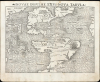
Novae Insulae XVII Nova Tabula.
First printed map of the Western Hemisphere in one of its earliest printings.
- Digital Map Information
- Suitable for large format printing
- Full resolution TIFF file
- ICC color profile embedded
- Delivered instantly via download link
First printed map of the Western Hemisphere in one of its earliest printings.
This is a superb example of Sebastian Münster's 1540 map of America, the first printed map of the Western Hemisphere. It is the first map to name the Pacific Ocean and the Straits of Magellan, and among the earliest acquirable maps to show and name Japan (Zipangri, located surprisingly close to America). This is the 2nd state of the map from the 1545 3rd printing of Geographia, marking this map as one of the handful printed during Münster's lifetime.A Closer Look
This bold, sharp woodcut presents North and South America as a continuous land mass (and is the first map to do so). It was also the first map to name the Pacific Ocean and the Straits of Magellan. It ranks among the earliest maps to show and name Japan (Zipangri). China and the Asian mainland are visible in the upper left; on the far right are the coastlines of Spain and Africa.Speculative Geography
There being vast gaps in European scholars' knowledge of the Americas, Münster had to fill in with speculation, leading to many of the unusual features. The wedge-like body of water bisecting North America was derived from interpretations of Verrazano's observations of the Carolina barrier islands and sounds beyond during his 1524 voyage. This so-called 'Sea of Verrazano' also appeared on Münster's world map. The Yucatan peninsula is here an island.Revealing and Summarizing the Age of Discovery in the Americas
The Caribbean region was reasonably well understood: Cuba, Jamaica, St. Paul, Cozumel, Yucatan, Dominica, and Hispaniola appear roughly in their correct positions. The Castilian flag flies over Puerto Rico (unnamed on this state of the map), and the Portuguese flag appears off the coast of Brazil. These refer to the Treaty of Tordesillas, the agreement between Spain and Portugal that determined which of the newly discovered areas belonged to each kingdom. In North America, the Florida peninsula is recognizable, although the entire region of the southeast is identified as 'Terra Florida.' Further north, another territory, defined as Francisca, is identified - applying Verrazano's term for the lands his expedition surveyed. This appellation was in honor of Francis I, the French King who sponsored Verrazano's expedition. 'C. Britonum' is a reference to Cabot's expedition and is most likely Cape Breton. The nearby island of Corte Real is possibly 'Terra Nova do Bacalhau' (New Land of the Codfish), supposedly discovered in 1473 by the Portuguese navigator Joao Vaz Corte-Real.South America is more recognizable. This (tied with Münster's world map) is the first acquirable map to name and show the Straits of Magellan. A lovely sailing ship in the Pacific is likely Magellan's flagship Victoria.
Catigara
Catigara, a city typically located in East Asia by Ptolemy, has here been relocated to the western coast of South America, near modern-day Peru. This development is consistent with the 1489 Martellus and the 1531 Oronce Fine maps. On the Martellus, Catigara appears on the western coast of the 'Dragon's Tail,' left over from Ptolemy's land bridge to Africa. Fine decided that the 'Dragon's Tail' appearing on earlier maps was the same land mass as the newly discovered South America and placed Catigara there accordingly. Münster completed that change, retaining Catigara while correctly mapping America and Asia as distinct continents.Cannibals and Giants
Thanks to Vespucci's popular and sensational accounts of the New World, if scholars knew anything about South America, it was that it was full of cannibals. Consequently, the region of Brazil is decorated with a primitive lean-to festooned with a human head and leg, labeled 'Canibali.' Patagonia is identified as 'Regio Gigantum' (the Kingdom of Giants) in reference to the ten-foot-tall giants reported by Magellan's survivors.The Earliest Printed Map of the Pacific Ocean
As noted previously, this is the earliest printed map (tied with Münster's world map) to use the term 'Pacific' to describe the ocean to the west of America. Münster most likely theorized that this was an extension of Ptolemy's Indian Ocean - a fact also suggested by his placement of 'Catigara.' Into this largely unexplored body of water he introduces the Ins. Pdonum, according to Suarez, a corruption of Magellan's 'Ladroni' or 'Thieves' Island', today's Guam and Rota. Münster also identifies 'Calensuan,' which Suarez suggests is one of the islands visited by Magellan's crew after the man himself was slain on Cebu. Further north, an archipelago of 7448 islands surrounds 'Zipangri.' This is Japan, as referenced by Marco Polo. It is among the earliest appearances of Japan on a printed map, and in its first edition of 1540, predated any direct European contact with the island nation.Publication History and Census
This map was printed for the third, 1545 edition of Münster's Geographia. The map is identical to that of the 1540 first edition, differing only in the typesetting of the title (the leaf motif appearing before the word 'Novae' and the lack of a comma after 'Insulae'), a slight movement of the 'Regio Gigantum' text block in South America, and typographical changes to the verso. With further typographical changes, the map remained in each edition of Geographia, of which the 1552 was the last. The map was also included in all editions of Münster's Cosmographia until 1578, after which the double-page maps of the long-lived work were replaced and updated. The four editions of Geographia are well represented in institutional collections. We see eight separate copies of the map in this state listed in OCLC.Cartographer
Sebastian Münster (January 20, 1488 - May 26, 1552), was a German cartographer, cosmographer, Hebrew scholar and humanist. He was born at Ingelheim near Mainz, the son of Andreas Munster. He completed his studies at the Eberhard-Karls-Universität Tübingen in 1518, after which he was appointed to the University of Basel in 1527. As Professor of Hebrew, he edited the Hebrew Bible, accompanied by a Latin translation. In 1540 he published a Latin edition of Ptolemy's Geographia, which presented the ancient cartographer's 2nd century geographical data supplemented systematically with maps of the modern world. This was followed by what can be considered his principal work, the Cosmographia. First issued in 1544, this was the earliest German description of the modern world. It would become the go-to book for any literate layperson who wished to know about anywhere that was further than a day's journey from home. In preparation for his work on Cosmographia, Münster reached out to humanists around Europe and especially within the Holy Roman Empire, enlisting colleagues to provide him with up-to-date maps and views of their countries and cities, with the result that the book contains a disproportionate number of maps providing the first modern depictions of the areas they depict. Münster, as a religious man, was not producing a travel guide. Just as his work in ancient languages was intended to provide his students with as direct a connection as possible to scriptural revelation, his object in producing Cosmographia was to provide the reader with a description of all of creation: a further means of gaining revelation. The book, unsurprisingly, proved popular and was reissued in numerous editions and languages including Latin, French, Italian, and Czech. The last German edition was published in 1628, long after Münster's death of the plague in 1552. Cosmographia was one of the most successful and popular books of the 16th century, passing through 24 editions between 1544 and 1628. This success was due in part to its fascinating woodcuts (some by Hans Holbein the Younger, Urs Graf, Hans Rudolph Manuel Deutsch, and David Kandel). Münster's work was highly influential in reviving classical geography in 16th century Europe, and providing the intellectual foundations for the production of later compilations of cartographic work, such as Ortelius' Theatrum Orbis Terrarum Münster's output includes a small format 1536 map of Europe; the 1532 Grynaeus map of the world is also attributed to him. His non-geographical output includes Dictionarium trilingue in Latin, Greek, and Hebrew, and his 1537 Hebrew Gospel of Matthew. Most of Munster's work was published by his stepson, Heinrich Petri (Henricus Petrus), and his son Sebastian Henric Petri. Further Details...
Source
Ptolemy, C., Geographia, (Basel: Petri) 1545.
Following in the footsteps of Martin Waldseemuller and Lorent Fries before him, Sebastian Munster edited and published a modernized version of Claudius Ptolemy's Geographia. This appeared in six Latin editions in 1540, 1541, 1542, 1545, 1551 and 1552. According to Karrow, Munster based the text on the Latin translation of Willibald Pirkheimer, but he carefully collated it with previous editions, adding notes of his own. The first three editions contained 48 maps, consisting of 27 based on Ptolemy's ancient geography, and 21 maps based on modern geographical knowledge. The latter three editions contained 54 maps, comprised of the same ancient works but with six of the modern maps discarded, and twelve new ones added. For the collector, the modern maps are of sharpest interest. Some were based on Waldseemuller's geography, but many were based on Munster's own surveys and those of other European geographers whose assistance Munster had been able to enlist. Most of these would be reprised in Munster's magnum opus, Cosmographia Universalis. A disproportionate number of Munster's modern maps show contemporary geographical knowledge of the their respective areas for the very first time: The first map to show the continents of the Western Hemisphere; the first map to focus on the continent of Asia; the first modern map to name the Pacific Ocean. Even in cases where earlier maps exist, Munster's works very often remain the earliest such acquirable by the collector.
Condition
Excellent. Slight marginal soiling, else a bold example with generous margins.
References
OCLC 431574742. Rumsey 11337.000 (1540). Burden, P., The Mapping of North America, 12 State 3 1545 edition. Suarez, T., Early Mapping of Southeast Asia…, p. 127. Suarez, T., Early Mapping of the Pacific. Suarez, T., Shedding the Veil, page 85.