This item has been sold, but you can get on the Waitlist to be notified if another example becomes available, or purchase a digital scan.
1540 / 1552 Munster Map of America (first obtainable map of America)
America-munster-1552-3$4,250.00

Title
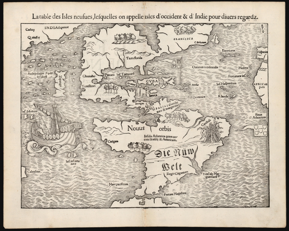
La table des Isles neufues, lesquelles on appelle isles d'occident et d Indie pour divers regardz.
1552 (undated) 10.5 x 13.5 in (26.67 x 34.29 cm) 1 : 50000000
1552 (undated) 10.5 x 13.5 in (26.67 x 34.29 cm) 1 : 50000000
Description
This is an excellent 1552 French-text edition of Sebastian Münster's 1540 map of America, the first printed map of the Western Hemisphere. From 1544, this map was included in Münster's Cosmographia. The 1552 editions are the last published in Münster's lifetime - after which production quality significantly declined. Cosmographia long outlasted Münster, remaining the best source for over 40 years for anyone who wished to know about the world. Consequently, this map had a disproportionate impact, providing the first glimpse of the New World to Europeans for nearly half a century.
The Castilian flag flies over Puerto Rico (unnamed), and the Portuguese flag appears off the coast of Brazil. These reference the Treaty of Tordesillas, the agreement between Spain and Portugal determining which newly discovered areas belonged to each kingdom. In North America, the Florida peninsula is recognizable, although the entire southeast region is identified as 'Terra Florida.' Further north, another territory, Francisca, is identified - applying Verrazano's term for the lands his expedition surveyed. This appellation honored Francis I, the French King who sponsored Verrazano's expedition. 'C. Britonum' references Cabot's expedition and is most like Cape Breton. The nearby island of 'Corterati' refers to the lands encountered in 1501 by Gaspar Corte-Real; it is not known now what specific land Corte-Real found but of the two likely possibilities - Labrador or Newfoundland - Münster presents a better picture for the latter.
South America is more recognizable. This map (tied with Münster's world map) is the first acquirable to name and show the Straits of Magellan. A lovely sailing ship in the Pacific is likely Magellan's flagship Victoria.
An Impressive Array of Firsts
In addition to being the first map to present North and South America as a continuous land mass, this was the first map to name the Pacific Ocean and the Straits of Magellan. It ranks among the earliest acquirable maps to show and name Japan, here located near America and named Zipangri. It was also the first widely disseminated map to reveal the discoveries of Verrazano and Cabot.Speculative Geography
Since there were vast gaps in European scholars' knowledge of the Americas, Münster and other geographers of his era relied heavily on educated speculation - leading to many of the unusual features apparent to the reader. The wedge-like body of water bisecting North America was derived from interpretations of Verrazano's observations of the Carolina barrier islands and sounds beyond during his 1524 voyage. This so-called 'Sea of Verrazano' would also appear on Münster's world map.Revealing and Summarizing the Age of Discovery in the Americas
The Caribbean region was reasonably well understood: Cuba, Jamaica, St. Paul, Cozumel, Yucatan, Dominica, and Hispaniola appear roughly in their correct positions. Nonetheless, the Yucatan peninsula is represented as an island in this otherwise reasonably well-realized area.The Castilian flag flies over Puerto Rico (unnamed), and the Portuguese flag appears off the coast of Brazil. These reference the Treaty of Tordesillas, the agreement between Spain and Portugal determining which newly discovered areas belonged to each kingdom. In North America, the Florida peninsula is recognizable, although the entire southeast region is identified as 'Terra Florida.' Further north, another territory, Francisca, is identified - applying Verrazano's term for the lands his expedition surveyed. This appellation honored Francis I, the French King who sponsored Verrazano's expedition. 'C. Britonum' references Cabot's expedition and is most like Cape Breton. The nearby island of 'Corterati' refers to the lands encountered in 1501 by Gaspar Corte-Real; it is not known now what specific land Corte-Real found but of the two likely possibilities - Labrador or Newfoundland - Münster presents a better picture for the latter.
South America is more recognizable. This map (tied with Münster's world map) is the first acquirable to name and show the Straits of Magellan. A lovely sailing ship in the Pacific is likely Magellan's flagship Victoria.
Catigara
Catigara, a city typically located in East Asia by Ptolemy, has here been relocated to the western coast of South America, near modern-day Peru. This development is consistent with the 1489 Martellus and the 1531 Oronce Fine maps. On the 1489 map, Catigara appears on the western coast of the 'Dragon's Tail' left over from Ptolemy's land bridge to Africa. Fine decided that the 'Dragon's Tail' appearing on earlier maps was the same land mass as the newly discovered South America and placed Catigara there accordingly. Münster completed that change, retaining Catigara while correctly mapping America and Asia as distinct continents.Cannibals and Giants
Thanks to Vespucci's popular and sensational accounts of the New World, if scholars knew anything about South America, it was that it was full of cannibals. Consequently, the region of Brazil is decorated with a primitive lean-to festooned with a human head and leg, labeled 'Canibali.' Patagonia is identified as 'Regio Gigantum' (the Kingdom of Giants) in reference to the ten-foot-tall giants reported by Magellan's survivors.The Earliest Printed Map of the Pacific Ocean
As noted previously, this is the earliest printed map (tied with Münster's world map) to use the term 'Pacific' to describe the ocean to the west of America. Munster most likely theorized that this ocean was an extension of Ptolemy's Indian Ocean - a fact also suggested by his placement of 'Catigara.' Into this largely unexplored ocean, he introduces the Ins. Pdonum, according to Suarez, a corruption of Magellan's 'Ladroni' or 'Thieves' Island', today's Guam and Rota. Münster also identifies 'Calensuan,' which Suarez suggests is one of the islands visited by Magellan's crew after the man himself was slain on Cebu. Further north, an archipelago of 7448 islands surrounds 'Zipangri.' This is Japan, as referenced by Marco Polo. It is among the earliest appearances of Japan on a printed map, and in its first edition of 1540 predated any direct European contact.Publication History and Census
This map first appeared in Münster's 1540 edition of Ptolemy's Geographia. Beginning in 1544, it was included in Münster's magnum opus, Cosmographia Universalis. It remained in that work until 1578. The present example is the 5th state of Münster's map according to Burden, and it conforms typographically to the 1552 French-text edition of Cosmographia. Only three examples of this edition appear separately in OCLC. In its various states, the map is well represented in institutional collections.Cartographer
Sebastian Münster (January 20, 1488 - May 26, 1552), was a German cartographer, cosmographer, Hebrew scholar and humanist. He was born at Ingelheim near Mainz, the son of Andreas Munster. He completed his studies at the Eberhard-Karls-Universität Tübingen in 1518, after which he was appointed to the University of Basel in 1527. As Professor of Hebrew, he edited the Hebrew Bible, accompanied by a Latin translation. In 1540 he published a Latin edition of Ptolemy's Geographia, which presented the ancient cartographer's 2nd century geographical data supplemented systematically with maps of the modern world. This was followed by what can be considered his principal work, the Cosmographia. First issued in 1544, this was the earliest German description of the modern world. It would become the go-to book for any literate layperson who wished to know about anywhere that was further than a day's journey from home. In preparation for his work on Cosmographia, Münster reached out to humanists around Europe and especially within the Holy Roman Empire, enlisting colleagues to provide him with up-to-date maps and views of their countries and cities, with the result that the book contains a disproportionate number of maps providing the first modern depictions of the areas they depict. Münster, as a religious man, was not producing a travel guide. Just as his work in ancient languages was intended to provide his students with as direct a connection as possible to scriptural revelation, his object in producing Cosmographia was to provide the reader with a description of all of creation: a further means of gaining revelation. The book, unsurprisingly, proved popular and was reissued in numerous editions and languages including Latin, French, Italian, and Czech. The last German edition was published in 1628, long after Münster's death of the plague in 1552. Cosmographia was one of the most successful and popular books of the 16th century, passing through 24 editions between 1544 and 1628. This success was due in part to its fascinating woodcuts (some by Hans Holbein the Younger, Urs Graf, Hans Rudolph Manuel Deutsch, and David Kandel). Münster's work was highly influential in reviving classical geography in 16th century Europe, and providing the intellectual foundations for the production of later compilations of cartographic work, such as Ortelius' Theatrum Orbis Terrarum Münster's output includes a small format 1536 map of Europe; the 1532 Grynaeus map of the world is also attributed to him. His non-geographical output includes Dictionarium trilingue in Latin, Greek, and Hebrew, and his 1537 Hebrew Gospel of Matthew. Most of Munster's work was published by his stepson, Heinrich Petri (Henricus Petrus), and his son Sebastian Henric Petri. More by this mapmaker...
Source
Münster, S., Cosmographia (Basel: Munster) 1552.
The Cosmographia Universalis, one of the greatest geographical and historical works of the 16th century, 'taught nearly three generations of laymen most of what they knew about the world beyond their native places' (Strauss). Filled with maps, views, and rich descriptions of places throughout Europe and beyond, it was the best general source of geographical information until the advent of Ortelius' Theatrum. It was first issued by Sebastian Munster (1488 - 1552) in its 1544 German edition, and stayed in print long after its author's death in thirty five editions, and in five languages. (Of these, the 1550 and 1552 editions are widely regarded as the most complete and truest to the author's intentions: thereafter, later editors continued to add to the work's text; editions from 1588 onwards employed an entirely different set of maps produced on Ortelius' model.) Munster's goal, initially, was to rally his homeland's humanists and scholars to produce a new map of Germany in order to 'see what kind of a land our ancestors conquered for their home... bring honor to our country and place its beauties in the clear light of day.' Munster's project quickly expanded to cover the known world in its scope to produce a 'sufficiently large volume, in which I touch upon the foundation of all nations and kingdoms, their peculiarities, rivers, mountains, customs of men, royal successions, origins of the more important cities, succinct histories, religions, characteristics and fertility of lands... in Germany, however, I tarry a little longer'.
Munster's methodology in Cosmographia is notable in particular for his dedication to providing his readers with direct access to firsthand reports of his subjects wherever possible. Many of the maps were the result of his own surveys; others, the fruit of an indefatigable letter writing campaign to scholars, churchmen and princes throughout Europe, amicably badgering them for maps, views, and detailed descriptions of their lands. For lands further afield than his letters could reach, Munster relied on the best that the authorities of northern European scholarship could offer: he was well familiar with the work of Waldseemuller and other geographers of the early 16th century, and was well connected with the best geographers of his own generation. A disproportionate number of the maps of Cosmographia show contemporary geographical knowledge of the their respective areas for the very first time: The first map to show the continents of the Western Hemisphere; the first map to focus on the continent of Asia; the first modern map to name the Pacific Ocean; the first map to use a key; the first modern map of the British Isles and so on. Even in cases where earlier maps exist, Munster's works very often remain the earliest such acquirable by the collector.
Munster's methodology in Cosmographia is notable in particular for his dedication to providing his readers with direct access to firsthand reports of his subjects wherever possible. Many of the maps were the result of his own surveys; others, the fruit of an indefatigable letter writing campaign to scholars, churchmen and princes throughout Europe, amicably badgering them for maps, views, and detailed descriptions of their lands. For lands further afield than his letters could reach, Munster relied on the best that the authorities of northern European scholarship could offer: he was well familiar with the work of Waldseemuller and other geographers of the early 16th century, and was well connected with the best geographers of his own generation. A disproportionate number of the maps of Cosmographia show contemporary geographical knowledge of the their respective areas for the very first time: The first map to show the continents of the Western Hemisphere; the first map to focus on the continent of Asia; the first modern map to name the Pacific Ocean; the first map to use a key; the first modern map of the British Isles and so on. Even in cases where earlier maps exist, Munster's works very often remain the earliest such acquirable by the collector.
Condition
Excellent. Reinforced at centerfold in margins, not entering printed image. Else fine.
References
Burden, P., The Mapping of North America, no. 12, state 5. Suarez, T., Early Mapping of Southeast Asia…, p. 127. Suarez, T., Early Mapping of the Pacific. Suarez, Shedding the Veil, page 85. OCLC: 930283758. Compare Rumsey 11623.000 (1540 Geographia).