
This item below is out of stock, but another example (left) is available. To view the available item, click "Details."
Details
1587 / 1589 Ortelius Map of America (English Colonies in North America)
1587 (dated) $5,750.00
1579 Ortelius Map of America (First issue of the second plate)
America-ortelius-1579$3,250.00


Title
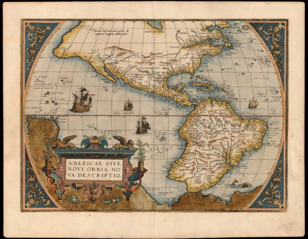
Americae Sive Novi Orbis Nova Descriptio.
1579 (undated) 14.25 x 19.75 in (36.195 x 50.165 cm) 1 : 40000000
1579 (undated) 14.25 x 19.75 in (36.195 x 50.165 cm) 1 : 40000000
Description
This a striking original-color example of Abraham Ortelius' map of the Western Hemisphere, 'first map of the Americas to appear in a modern atlas' (Schwartz). Ortelius' success and the spread of his atlas made this map the standard - and best - representation of the Americas during the initial period of the European colonization.
First Issue, Second Plate
The present example is the 1579 first issue of the map's second plate, in beautiful original color. This second plate was executed to replace the 1570 plate, which had developed cracks that could no longer be mended. The new plate is mainly distinguishable from the first by the largest of the ships in the Pacific (sailing eastwards instead of westwards) and the presence of gradations along the equator. Otherwise, this map retains all the geographical information of the earlier edition.On The Map
Given how recently the Western Hemisphere had come to the attention of European scholars, the outline of the continent is remarkably accurate and recognizable. The American Northeast is dominated by Nova Francia and the St. Lawrence, showing evidence from Cartier's voyages. The Caribbean and eastern South America are remarkably accurate. The Strait of Magellan is shown, although Tierra del Fuego still appears as part of a massive southern continent extending all the way to New Guinea. The Pacific Ocean is optimistically narrower than actuality, with New Guinea appearing south of Quivira and the Strait of Anian. The Pacific coast shows great distortion both in North and South America. The Chilean coast features the 'Potato-shaped' bulge also found on Mercator's map. In Mexico and the Southwest, Coronado's placenames of Cevola, Tiguex, and Quivira appear. Peru and the Rio de la Plata are well detailed, although the size of the latter is exaggerated.Ortelius' Sources
The general shape of the continent and many of its details were drawn from the maps of Ortelius' friend and fellow mapmaker Gerard Mercator's massive (and unobtainable) 1669 world map. Much of the fine detail was derived from Spanish sources - itself a remarkable accomplishment, as the Spanish and Portuguese were famously secretive regarding their discoveries, particularly in the New World. These sources, naturally, are nameless - but the sharp detail of the parts of the Americas within the Spanish sphere gives the game away.Elegant and Distinctive
In addition to its revealing detail, Ortelius' map is a beautiful work: ships sail the stippled oceans, and a sea monster prowls the South Atlantic. The garlanded, strapwork cartouche is surmounted with winged lions. The map's lettering is clear and legible throughout. The engraver of the plate is not known, but was probably associated with the Plantin publishing house who had taken over publication of Ortelius' atlas.Publication History and Census
The map was engraved for inclusion in the 1579 edition of the Theatrum and remained in the atlas until its replacement in 1587 by a further plate, approximately 2025 copies having been printed. Some 250 of these belonged to the 1579 (variant A) Latin text edition, to which this example belongs. Examples of various editions of this map are well represented in institutional collections.Cartographer
Abraham Ortelius (April 14, 1527 - June 28, 1598) also known as Ortels, was a cartographer, geographer, and cosmographer of Brabant, active in Antwerp. He was the creator of the first modern atlas, Theatrum Orbis Terrarum and is a seminal figure in the history of cartography. Along with Gerard Mercator and Gemma Frisius, he was a founder of the Netherlandish school of cartography. His connections with Spain - culminating in his 1575 appointment as Royal Cartographer to King Phillip II of Spain - gave him unmatched access to Spanish geographical knowledge during a crucial period of the Age of Discovery. Ortelius was born in 1527 in Antwerp. In 1547 he entered the Antwerp Guild of Saint Luke as an illuminator of maps. He began trading in books, prints, and maps, traveling regularly to the Frankfurt book and print fair, where in 1554 he met Mercator. He accompanied Mercator on journeys throughout France in 1560 and it was at this time, under Mercator's influence, that he appears to have chosen his career as a scientific geographer. His first published geographic work appeared in 1564, an eight-sheet cordiform world map. A handful of other maps preceded the 1570 publication of the first edition of the Theatrum Orbis Terrarum, which would prove to be his life work. Appearing with but 53 maps in its first edition, Ortelius' work expanded with new maps added regularly. By 1592, it had 134 maps. Many of Ortelius' maps remained the standard for nearly a century. He traveled extensively, but his genius was as a compiler, locating the best informed maps on which to base his own. His contacts throughout Europe and extending even (via the Portuguese) to the Far East were formidable. Moreover, many of his maps were based on his own scholarship, particularly his historical works. His theories of geography were particularly ahead of his time with respect to the notion of continental drift, the possibility of which he mused on as early as 1596, and which would be proven correct centuries later.
In a sense his greatest achievement was his successful navigation of the religious and political violence endemic to his city throughout his adult life: The Dutch Revolt, or Eighty Years' War (1568 - 1648), fully embroiled Antwerp. Although outwardly and officially recognized as Catholic (Arias Montanus vouched for Ortelius' Catholic orthodoxy prior to his appointment as Royal Geographer), Ortelius was able to separate himself from the religious furor which characterized the war in the low countries. Ortelius showed a glimpse of himself in a letter to a friend, regarding humanist Justus Lipsius: 'I do not know whether he is an adherent of the Pope or a Calvinist, but if he has ears to hear, he will neither be one nor the other, for sins are committed on both sides'. Ortelius' own explorations of Biblical history in his maps, and the Christogram contained in his own motto, suggest him to be a religious man, but his abjuration of political religious authorities mark him as an individualist. His tombstone at St Michael's Præmonstratensian Abbey in Antwerp bears the inscription, Quietis cultor sine lite, uxore, prole. ('served quietly, without accusation, wife, and offspring.') More by this mapmaker...
Source
Ortelius, Abraham, Theatrvm orbis terrarvm, (Antwerp: Plantin) 1579.
Abraham Ortelius' magnum opus, Theatrum Orbis Terrarum, was the world's first regularly produced atlas, which 'set the standards for later atlases . . . It was the first undertaking of its kind to reduce the best available maps to an uniform format.' (Koeman) A modestly-sized work of fifty-three maps in its first edition of May 1570, it was an immediate success: there were three further editions that year, and the work remained in print for a total of 32 editions, the last of which was 1641, well after its author's 1598 death. Ortelius added to his atlas constantly, and by 1595 the Theatrum contained 147 maps. Ortelius is renowned generally as an editor, and indeed much of the Theatrum is compiled from a variety of sources: in such cases, Ortelius was scrupulous in naming his sources. But Ortelius was also a mapmaker in his own right: many of his maps are a distillation of various sources into his own work, and there were many maps - particularly in his atlas of Biblical and ancient history Parergon - which were entirely Ortelius' work. In his role as an editor, Ortelius followed in the footsteps of Munster, whose Cosmographia was, until Ortelius, the best window on the world for the curious European reader. In terms of the artistry of his maps, Ortelius oversaw the first great flourishing of copperplate engraving in the service of cartography to occur in Northern Europe. Ortelius' work provided the model for the atlases of Mercator, Hondius, Blaeu and all their progeny in the 17th century - many of whom were to produce faithful editions of Ortelius' maps in their own productions.
Condition
Very good. Minor scuffing at centerfold, else excellent with a bold strike and fine original color.
References
OCLC 1027665138. Plate 2 not in Rumsey. Van den Broecke, Ort10. Burden, P., The Mapping of North America, 52.