This item has been sold, but you can get on the Waitlist to be notified if another example becomes available, or purchase a digital scan.
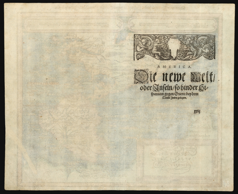
1588 Petri / Münster Map of America
AmericaeSiveNoviOrbis-munster-1588-2$750.00


Title
Americae Sive Novi Orbis Nova Descriptio. / Die newen Inseln so hinder Hispaniam gegen Orient, bey dem Landt Indie gelegen.
1588 (undated) 13 x 14.5 in (33.02 x 36.83 cm) 1 : 59500000
1588 (undated) 13 x 14.5 in (33.02 x 36.83 cm) 1 : 59500000
Description
This evocative map of the western hemisphere was added to Münster's Cosmographia in 1588 as part of Sebastian Petri's extensive update of the work. The map covers all of North and South America from the mysterious inland bay (Conibas, on the map's precursors) to Tierra del Fuego and from New Guinea to beyond the easternmost coast of Brazil. It is based almost entirely on Ortelius' 1570 map of the same region but is visually distinct, being a woodcut rather than copperplate engraving.
A Closer Look
The American Northeast is dominated by Nova Francia and the St. Lawrence, showing evidence from Cartier's voyages there. The delineation of the Caribbean and eastern South America is illustrated reasonably accurately. The Strait of Magellan is shown, though Tierra del Fuego appears not as an island but as part of a massive southern continent extending all the way to New Guinea. The Pacific Ocean itself appears optimistically far narrower than it actually is, with New Guinea appearing south of Quivira and the strait of Anian. The Pacific coast, indeed, shows significant distortion both in North and South America. The Chilean coast shows the 'Potato-shaped' bulge characteristic also found on Mercator's map.A New Set of Maps
The map replaced by this one had, in its first printing of 1540, been the earliest printed map of the western hemisphere. With the advent of Ortelius' Theatrum and its Mercator-based map of America, the old Münster map was woefully obsolete. Sebastian Petri, Münster's step-grandson and heir to Münster's publisher Heinrich Petri, updated the maps of Cosmographia extensively, replacing them with woodcuts based on Ortelius such as this one.Publication History and Census
This map was among the newly-produced woodcut maps added to the 1588 German edition of Cosmographia by Sebastian Petri. It remained in subsequent editions without material change. The present example conforms typographically to the map found in the 1592 edition. The Petri editions of Cosmographia are well represented in institutional collections, as is the separate map.CartographerS
Sebastian Münster (January 20, 1488 - May 26, 1552), was a German cartographer, cosmographer, Hebrew scholar and humanist. He was born at Ingelheim near Mainz, the son of Andreas Munster. He completed his studies at the Eberhard-Karls-Universität Tübingen in 1518, after which he was appointed to the University of Basel in 1527. As Professor of Hebrew, he edited the Hebrew Bible, accompanied by a Latin translation. In 1540 he published a Latin edition of Ptolemy's Geographia, which presented the ancient cartographer's 2nd century geographical data supplemented systematically with maps of the modern world. This was followed by what can be considered his principal work, the Cosmographia. First issued in 1544, this was the earliest German description of the modern world. It would become the go-to book for any literate layperson who wished to know about anywhere that was further than a day's journey from home. In preparation for his work on Cosmographia, Münster reached out to humanists around Europe and especially within the Holy Roman Empire, enlisting colleagues to provide him with up-to-date maps and views of their countries and cities, with the result that the book contains a disproportionate number of maps providing the first modern depictions of the areas they depict. Münster, as a religious man, was not producing a travel guide. Just as his work in ancient languages was intended to provide his students with as direct a connection as possible to scriptural revelation, his object in producing Cosmographia was to provide the reader with a description of all of creation: a further means of gaining revelation. The book, unsurprisingly, proved popular and was reissued in numerous editions and languages including Latin, French, Italian, and Czech. The last German edition was published in 1628, long after Münster's death of the plague in 1552. Cosmographia was one of the most successful and popular books of the 16th century, passing through 24 editions between 1544 and 1628. This success was due in part to its fascinating woodcuts (some by Hans Holbein the Younger, Urs Graf, Hans Rudolph Manuel Deutsch, and David Kandel). Münster's work was highly influential in reviving classical geography in 16th century Europe, and providing the intellectual foundations for the production of later compilations of cartographic work, such as Ortelius' Theatrum Orbis Terrarum Münster's output includes a small format 1536 map of Europe; the 1532 Grynaeus map of the world is also attributed to him. His non-geographical output includes Dictionarium trilingue in Latin, Greek, and Hebrew, and his 1537 Hebrew Gospel of Matthew. Most of Munster's work was published by his stepson, Heinrich Petri (Henricus Petrus), and his son Sebastian Henric Petri. More by this mapmaker...
Heinrich Petri (1508 - 1579) and his son Sebastian Henric Petri (1545 – 1627) were printers based in Basel, Switzerland. Heinrich was the son of the printer Adam Petri and Anna Selber. After Adam died in 1527, Anna married the humanist and geographer Sebastian Münster - one of Adam's collaborators. Sebastian contracted his stepson, Henricus Petri (Petrus), to print editions of his wildly popular Cosmographia. Later Petri, brought his son, Sebastian Henric Petri, into the family business. Their firm was known as the Officina Henricpetrina. In addition to the Cosmographia, they also published a number of other seminal works including the 1566 second edition of Nicolaus Copernicus's De Revolutionibus Orbium Coelestium and Georg Joachim Rheticus's Narratio. Learn More...
Abraham Ortelius (April 14, 1527 - June 28, 1598) also known as Ortels, was a cartographer, geographer, and cosmographer of Brabant, active in Antwerp. He was the creator of the first modern atlas, Theatrum Orbis Terrarum and is a seminal figure in the history of cartography. Along with Gerard Mercator and Gemma Frisius, he was a founder of the Netherlandish school of cartography. His connections with Spain - culminating in his 1575 appointment as Royal Cartographer to King Phillip II of Spain - gave him unmatched access to Spanish geographical knowledge during a crucial period of the Age of Discovery. Ortelius was born in 1527 in Antwerp. In 1547 he entered the Antwerp Guild of Saint Luke as an illuminator of maps. He began trading in books, prints, and maps, traveling regularly to the Frankfurt book and print fair, where in 1554 he met Mercator. He accompanied Mercator on journeys throughout France in 1560 and it was at this time, under Mercator's influence, that he appears to have chosen his career as a scientific geographer. His first published geographic work appeared in 1564, an eight-sheet cordiform world map. A handful of other maps preceded the 1570 publication of the first edition of the Theatrum Orbis Terrarum, which would prove to be his life work. Appearing with but 53 maps in its first edition, Ortelius' work expanded with new maps added regularly. By 1592, it had 134 maps. Many of Ortelius' maps remained the standard for nearly a century. He traveled extensively, but his genius was as a compiler, locating the best informed maps on which to base his own. His contacts throughout Europe and extending even (via the Portuguese) to the Far East were formidable. Moreover, many of his maps were based on his own scholarship, particularly his historical works. His theories of geography were particularly ahead of his time with respect to the notion of continental drift, the possibility of which he mused on as early as 1596, and which would be proven correct centuries later.
In a sense his greatest achievement was his successful navigation of the religious and political violence endemic to his city throughout his adult life: The Dutch Revolt, or Eighty Years' War (1568 - 1648), fully embroiled Antwerp. Although outwardly and officially recognized as Catholic (Arias Montanus vouched for Ortelius' Catholic orthodoxy prior to his appointment as Royal Geographer), Ortelius was able to separate himself from the religious furor which characterized the war in the low countries. Ortelius showed a glimpse of himself in a letter to a friend, regarding humanist Justus Lipsius: 'I do not know whether he is an adherent of the Pope or a Calvinist, but if he has ears to hear, he will neither be one nor the other, for sins are committed on both sides'. Ortelius' own explorations of Biblical history in his maps, and the Christogram contained in his own motto, suggest him to be a religious man, but his abjuration of political religious authorities mark him as an individualist. His tombstone at St Michael's Præmonstratensian Abbey in Antwerp bears the inscription, Quietis cultor sine lite, uxore, prole. ('served quietly, without accusation, wife, and offspring.') Learn More...
Source
Munster, S., Cosmographica, (Sebastain Petri, Basel) 1592.
Condition
Very good. Reinforced printer's crease entering image at lower right.
References
OCLC 234201672, 43414807. Burden, P., The Mapping of North America, #67. Wheat, C. I., Mapping of the Transmississippi West, 1540 – 1861, v.1, no. 20.