
1936 Jo Mora Vignettes of Native American Life (First Edition)


Indians of North America.
Collage of American Indian Culture.
- Digital Map Information
- Suitable for large format printing
- Full resolution TIFF file
- ICC color profile embedded
- Delivered instantly via download link
Collage of American Indian Culture.
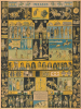
This rare first edition of Jo Mora's 1936 Indians of North America presents a pictorial chart that brings his longstanding study of Native American life into the decorative format of his celebrated cartes. Rather than locating peoples on a conventional map, Mora assembles a visual survey of clothing, dwellings, transportation, craftsmanship, and ceremonial life. Its particular emphasis on the Southwest reflects his years among the Hopi and Navajo, and some of the objects illustrated belonged to his own collection. The dedication to his friend, trader Lorenzo Hubbell, makes that personal connection explicit.A Closer Look
The sheet is organized into interlocking panels, with broad horizontal bands of figures and textiles enclosed by narrow displays of weapons, utensils, jewelry, pottery, and basketry. A black background highlights the silhouettes of mounted riders, ceremonial figures, and individual objects, while yellow and blue fields distinguish comparative groups. The arrangement invites close examination across cultures: differences in dress, construction, and decoration replace the boundaries and place-names of a geographical map.Across the top, a mounted buffalo hunter is flanked by scenes of Plains horsemanship and warfare, including a side rider, a Dog Soldier, a war chief, and warriors counting coup. The latter refers to an act of bravery involving close contact with an enemy, such as touching him with a whip or coup stick, rather than necessarily killing him. Below, a prominent tipi is accompanied by smaller illustrations of a California wikiup, Navajo hogan, Seminole dwelling, Wichita grass house, bark wigwam, Mandan earth lodge, and Iroquois longhouse. This juxtaposition gives architectural variety a conspicuous place alongside the more dramatic equestrian imagery.
Transportation is similarly comparative. A birchbark canoe and hide bullboat appear opposite a dog-drawn toboggan and travois drawn by both dog and horse. A central Northwest Coast panel combines a ceremonial chief, totem pole, masks, paddles, house, and decorated canoe. Elsewhere, full-length figures and a continuous band of heads emphasize clothing, hairstyles, ornament, and body decoration. The abbreviation key at lower left identifies Plains, Pueblo, Forest, and Northwest Coast groupings, supplemented throughout by more specific tribal and regional labels.
The Southwest receives sustained attention. Navajo blankets form a broad ornamental band above a mounted Navajo figure and a weaving scene, while another panel reproduces a fragment of a Navajo sandpainting. Hopi figures, including a Snake Dancer, occupy the lower portion of the sheet beside Pueblo ceremonial figures and a terraced settlement. These scenes connect the chart to Joseph Jacinto Mora's (1876 - 1947) earlier work in Arizona, where he lived among the Hopi and Navajo during 1904 - 1906, making photographs, paintings, and drawings that continued to inform his art.
Mora explains his purpose in the signed statement near the bottom: he found it difficult to choose from an abundance of material, and he hoped the chart would provide instruction and pleasure while encouraging further study. The result is a popular illustrated introduction rather than a systematic ethnographic atlas. Its broad regional categories and juxtaposition of historical and ceremonial subjects reflect Mora's selective presentation, not a comprehensive account of contemporary Native American life.
Publication History and Census
The chart was published in Carmel, California, by The Jo Mora Maps in 1936. Following Gilmore's identification, this is the first edition, distinguished by The Jo Mora Maps name in the lower-left key and the absence of an additional publisher's imprint in the outer lower-left margin. Both features are present in the supplied image. The Monterey History and Art Association records a second printing by Jo Mora Publications in 1942 and a third in 1950; the latter retained the original 1936 copyright date.Geographicus's established holdings research records examples at the University of California, Berkeley; University of Arizona; University of Texas at Arlington; New York Public Library; Brigham Young University; Wichita Public Library; and Buffalo and Erie County Public Library. These holdings refer to the chart and should not be understood as a census specifically of the first edition.
Cartographer
Joseph 'Jo' Jancito Mora (October 22, 1876 – October 10, 1947) was an Uruguayan born artist active in California during the first half of the 20th century. Mora immigrated to California as a young man. He studied art in Boston and, after graduating, worked there briefly before relocating to California. In cartographic circles Mora is known for pioneering the 20th century pictorial map. In a series he referred to as his 'cartes,' published between in 1926 and 1942, Mora developed a pictorial style that combined cartography with colorful cartoonish image of local figures, folklore, history, and natural wonders. His earliest maps were commissioned by the Hotel Del Monte and included California's Playground and The Seventeen Mile Drive. As he matured as a cartographer, his work became increasingly dense, often packed with tiny figures, each expressive of some aspect of regional life. Mora, often called the 'Renaissance man of the West' also worked as an illustrator, muralist, sculptor, photographer, and writer. His masterpiece is considered to be the Father Serra Cenotaph, a bronze and marble sculpture at the Memorial Chapel in El Carmelo Mission, Carmel, California. His map work included Monterey Penninsula (1927), and Seventeen Mile Drive (1927), California (1927), Grand Canyon (1931), Yosemite (1931), Yellowstone (1936), Carmel-By-The-Sea (1942), California (1945) (large and small versions), Map of Los Angeles (1942), among others. Further Details...
Condition
Very good. Minor dampstains along left side, very faint.
References
OCLC 992806468, 227472005, 41348541. Gilmore, J., Jo Mora's Cartes and Maps, #M14.