1818 Fried Folding Map of the Americas, Ephemeral Borders
Americas-fried-1818$1,800.00
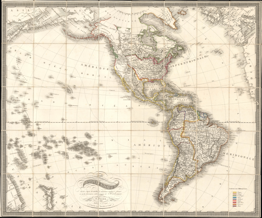

Title
Carte de l'Amerique dressée d'après les meilleurs materiaux anglais, francais et sur les observations astronomiques de Mr. de Humboldt.
1818 (dated) 30.75 x 37.25 in (78.105 x 94.615 cm) 1 : 23500000
1818 (dated) 30.75 x 37.25 in (78.105 x 94.615 cm) 1 : 23500000
Description
This is Franz Fried's scarce 1818 folding map of the Americas, published by Artaria of Vienna. The map is significant for capturing the fast-paced political changes sweeping the continent in the wake of the Napoleonic Wars (1803 - 1815) and the breakdown of Spanish hegemony in Latin America.
The map is notable for incorporating both up-to-date geographic knowledge (i.e. along the western coast of North America and in Oceania) and evolving boundaries in the newly independent states of the Americas. Both independent states and colonies are traced in color according to the legend at bottom-right. The meandering border between the United States and British colonies to its north (i.e. Canada) is particularly unusual. The western and northern portions of North America are unsurprisingly blank in places, or otherwise noted with non-committal phrases like 'pays inconnus' or 'Indiens,' given the imperfect information available about these areas.
It is noteworthy that the map is in French and uses Paris as a Prime Meridian despite its maker being Austrian. This could be a reflection of the continued prestige of French sciences and cartography in the aftermath of the French Revolution and Napoleonic Wars, and probably also is a product of the cosmopolitanism environment of Vienna (the map's publisher was an Italian-origin family known for publishing Mozart and Hayden). Fried did produce other maps in French, but by the mid-1820s all of his work was in German, save for updated editions of his earlier French maps.
A Closer Look
This beautifully engraved map covers the Americas, noting settlements, Native American groups, and topographic features throughout. It is similarly fastidious in mapping the islands of the Pacific and including portions of Asia, Europe, and Africa along the edges; although this really was not necessary for the map, it does help situate the Americas in the global context (with an interesting projection reflecting the curvature of the Earth, perhaps the result of Humbolt's astronomical observations referenced in the title).The map is notable for incorporating both up-to-date geographic knowledge (i.e. along the western coast of North America and in Oceania) and evolving boundaries in the newly independent states of the Americas. Both independent states and colonies are traced in color according to the legend at bottom-right. The meandering border between the United States and British colonies to its north (i.e. Canada) is particularly unusual. The western and northern portions of North America are unsurprisingly blank in places, or otherwise noted with non-committal phrases like 'pays inconnus' or 'Indiens,' given the imperfect information available about these areas.
It is noteworthy that the map is in French and uses Paris as a Prime Meridian despite its maker being Austrian. This could be a reflection of the continued prestige of French sciences and cartography in the aftermath of the French Revolution and Napoleonic Wars, and probably also is a product of the cosmopolitanism environment of Vienna (the map's publisher was an Italian-origin family known for publishing Mozart and Hayden). Fried did produce other maps in French, but by the mid-1820s all of his work was in German, save for updated editions of his earlier French maps.
The Dissolution of Spain's American Empire
This map was prepared as Spain's American empire was collapsing, in large part as a result of the Napoleonic Wars and the French occupation of much of Spain. As elsewhere in the Atlantic World, the ideas of the Enlightenment also laid the groundwork for a desire for new political arrangements. The 1810s were especially chaotic, as Creole elites such as Simon Bolivar (1783 - 1830) soured on the old country and aimed to declare independence. Spain counter-attacked when it could, often winning back territory, if only temporarily, which helps explain the unusual borders and toponyms in South America.Publication History and Census
This map was prepared by Franz Fried and published by Artaria in Vienna in 1818. The 'No. 1' at top-left and a similar notation, 'No. II' partially cut off, refer to the four sheets on which the map was initially printed before being mounted on linen (areas of slight misalignment indicate where these sheets meet). This map is quite rare, only being noted among the holdings of the National Library of Australia and with no known market history, while the British Library holds a later map of the same title, subtitled 'corrigée 1841,' likely a later edition.Cartographer
Artaria and Company (1765 - c. 1890) was founded by Carlo Giovanni Artaria in 1765 in Vienna, then the capital of the Austro-Hungarian Empire. Originally a specialty publisher of sheet music, including works by Hayden, Mozart, Beethoven, and Schubert, the company had expanded its business to include maps by the mid-1770s. The company collaborated with Joseph von Scheda and distributed maps for the Militärgeografischen Institutes. Artaria continued to be a major European publisher well into the 20th century. In 1920, the cartographic section was sold to Freytag and Berndt, who published under the imprint Freytag-Berndt & Artaria. More by this mapmaker...
Condition
Very good. Dissected and mounted on linen as issued. Accompanied by original slipcase.
References
OCLC 224206718.