This item has been sold, but you can get on the Waitlist to be notified if another example becomes available, or purchase a digital scan.
1640 Petrus Bertius Separate Issue Map of America
Amerique-bertius-1640$1,200.00

Title
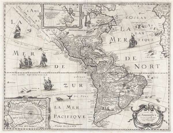
Carte de L'Amerique Corrigee et augmentee dessus toutes les autres cy devant faictes.
1640 (dated) 15 x 20 in (38.1 x 50.8 cm) 1 : 31000000
1640 (dated) 15 x 20 in (38.1 x 50.8 cm) 1 : 31000000
Description
This is a rare and significant separately issued 1640 map of America by Petrus Bertius. The map covers all of North and South America, as well as Central America, the West Indies, and the surrounding areas, including adjacent parts of Spain, Portugal, and Africa. Insets in the upper and lower left quadrants detail the north and south polar regions, respectively. Splendidly engraved sailing ships and sea monsters ply the oceans. The present example is the second state of the map, engraved and issued after Bertius' death by Michal van Lochem.
Cartographically the map is derived from the 1618 map by Bertius' brother-in-law Jodocus Hondius. There are several significant updates, including ghosting the entire west coast of North America north of Baja California (1640) and the completion of Tierra del Fuego in insular form (1624).
Ghosted Pacific Northwest
Burden suggests that this map's most significant point of differentiation from earlier publications. The American coast north of Baja California roughly follows the coastline laid down by Hondius in 1618, but here it is ghosted in rather than confidently displayed. This is a technique used by cartographers to indicate questionable cartography. In this case, there was considerable debate about his region. Some cartographers argued that California was an Island, while others, like Bertius/Lochem, argued for a peninsular form.
The Great Lakes?
One or possibly two of the Great Lakes are illustrated and are much advanced over the Hondius 1618 map – doubtless in reference to the discoveries of Samuel de Champlain and Jacques Cartier. On a tributary of the Saint Lawrence River, there is a small lake followed by a larger lake and the note, Premier Sault (the Lachine Rapids), potentially referring to Lake Ontario and Lake Erie. Niagara Falls, which is not identified, was not discovered until Louis Hennepin visited in 1678.
Lake Parima and El Dorado
Most Europeans believed that the most likely site of El Dorado legend was the mythical city of Manoa located here on the shores of the Lake Parima, near modern day Guyana, Venezuela, or northern Brazil. Manoa was first identified by Sr. Walter Raleigh in 1595. Raleigh does not visit the city of Manoa (which he believes is El Dorado) himself due to the onset of the rainy season, however he describes the city, based on indigenous accounts, as resting on a salt lake over 200 leagues wide. This lake, though no longer mapped as such, does have some basis in fact. Parts of the Amazon were, at the time dominated by a large and powerful Indigenous trading nation known as the Manoa. The Manoa traded the length and breadth of the Amazon. The onset of the rainy season inundated the great savannahs of the Rupununi, Takutu, and Rio Branco or Parima Rivers. This inundation briefly connected the Amazon and Orinoco river systems, opening an annual and well used trade route for the Manoans. The Manoans who traded with the Incans in the western Amazon, had access to gold mines on the western slopes of the Andes, and so, when Raleigh saw gold rich Indian traders arriving in Guyana, he made the natural assumption for a gold hungry European in search of El Dorado. When he asked the Orinocans where the traders were from, they could only answer, 'Manoa.' Thus, did Lake Parime or Parima and the city of Manoa begin to appear on maps in the early 17th century. The city of Manoa and Lake Parima would continue to be mapped in this area until about 1800.
Amazon Paradise? Eupana or the Laguna de Xarayes
Further South the mythical lake of Eupana, or as it was more commonly known, the Laguna de Xarayes is illustrated as the sourc eof the Paraguay River. The Xarayes, a corruption of 'Xaraies' meaning 'Masters of the River', were an indigenous people occupying what are today parts of Brazil's Matte Grosso and the Pantanal. When Spanish and Portuguese explorers first navigated up the Paraguay River, as always in search of El Dorado, they encountered the vast Pantanal flood plain at the height of its annual inundation. Understandably misinterpreting the flood plain as a gigantic inland sea, they named it after the local inhabitants, the Xaraies. The Laguna de los Xarayes almost immediately began to appear on early maps of the region and, at the same time, to take on a legendary quality. Later missionaries and chroniclers, particularly Díaz de Guzman, imagined an island in this lake and curiously identified it as an 'Island of Paradise,'
Massing intermittently at the base of the map and fully occupying the lower left inset is the speculative southern continent or as here 'Terre Antarcti Que Incognave. Long before the discovery of Antarctica, the southern continent, supposedly capping the South Pole, was speculated upon by European geographers of the 16th and 17th centuries. It was thought, based upon eh writings of Aristotle, that the globe was a place of balances and thus geographers presumed the bulk of Eurasia must be counterbalanced by a similar landmass in the Southern Hemisphere, just as, they argued, the Americas counterbalanced Africa and Europe. Many explorers in the 16th and 17th centuries sought the Great Southern continent, including Quiros, Drake, and Cook, but Antarctica itself was not truly discovered until Edward Bransfield and William Smith sighted the Antarctic Peninsula in 1820.
Publication History
This map was first issued in 1624 although there are no known examples of that edition. The present second edition, published in 1640 after Bertius' death, is the earliest acquirable edition, and is attributed to Michal von Lochem. This edition is also significant for the addition of a ghosted coastline in the unexplored Pacific Northwest. A third 1646 edition was issued in Paris by Pierre Mariette. Similar separate issue charts, also derived from 1618 Hondius, were also published by Melchoir Tavernier.
Cartographically the map is derived from the 1618 map by Bertius' brother-in-law Jodocus Hondius. There are several significant updates, including ghosting the entire west coast of North America north of Baja California (1640) and the completion of Tierra del Fuego in insular form (1624).
Ghosted Pacific Northwest
Burden suggests that this map's most significant point of differentiation from earlier publications. The American coast north of Baja California roughly follows the coastline laid down by Hondius in 1618, but here it is ghosted in rather than confidently displayed. This is a technique used by cartographers to indicate questionable cartography. In this case, there was considerable debate about his region. Some cartographers argued that California was an Island, while others, like Bertius/Lochem, argued for a peninsular form.
The Great Lakes?
One or possibly two of the Great Lakes are illustrated and are much advanced over the Hondius 1618 map – doubtless in reference to the discoveries of Samuel de Champlain and Jacques Cartier. On a tributary of the Saint Lawrence River, there is a small lake followed by a larger lake and the note, Premier Sault (the Lachine Rapids), potentially referring to Lake Ontario and Lake Erie. Niagara Falls, which is not identified, was not discovered until Louis Hennepin visited in 1678.
Lake Parima and El Dorado
Most Europeans believed that the most likely site of El Dorado legend was the mythical city of Manoa located here on the shores of the Lake Parima, near modern day Guyana, Venezuela, or northern Brazil. Manoa was first identified by Sr. Walter Raleigh in 1595. Raleigh does not visit the city of Manoa (which he believes is El Dorado) himself due to the onset of the rainy season, however he describes the city, based on indigenous accounts, as resting on a salt lake over 200 leagues wide. This lake, though no longer mapped as such, does have some basis in fact. Parts of the Amazon were, at the time dominated by a large and powerful Indigenous trading nation known as the Manoa. The Manoa traded the length and breadth of the Amazon. The onset of the rainy season inundated the great savannahs of the Rupununi, Takutu, and Rio Branco or Parima Rivers. This inundation briefly connected the Amazon and Orinoco river systems, opening an annual and well used trade route for the Manoans. The Manoans who traded with the Incans in the western Amazon, had access to gold mines on the western slopes of the Andes, and so, when Raleigh saw gold rich Indian traders arriving in Guyana, he made the natural assumption for a gold hungry European in search of El Dorado. When he asked the Orinocans where the traders were from, they could only answer, 'Manoa.' Thus, did Lake Parime or Parima and the city of Manoa begin to appear on maps in the early 17th century. The city of Manoa and Lake Parima would continue to be mapped in this area until about 1800.
Amazon Paradise? Eupana or the Laguna de Xarayes
Further South the mythical lake of Eupana, or as it was more commonly known, the Laguna de Xarayes is illustrated as the sourc eof the Paraguay River. The Xarayes, a corruption of 'Xaraies' meaning 'Masters of the River', were an indigenous people occupying what are today parts of Brazil's Matte Grosso and the Pantanal. When Spanish and Portuguese explorers first navigated up the Paraguay River, as always in search of El Dorado, they encountered the vast Pantanal flood plain at the height of its annual inundation. Understandably misinterpreting the flood plain as a gigantic inland sea, they named it after the local inhabitants, the Xaraies. The Laguna de los Xarayes almost immediately began to appear on early maps of the region and, at the same time, to take on a legendary quality. Later missionaries and chroniclers, particularly Díaz de Guzman, imagined an island in this lake and curiously identified it as an 'Island of Paradise,'
...an island [of the Paraguay River] more than ten leagues [56 km] long, two or three [11-16 km] wide. A very mild land rich in a thousand types of wild fruit, among them grapes, pears and olives: the Indians created plantations throughout, and throughout the year sow and reap with no difference in winter or summer, ... the Indians of that island are of good will and are friends to the Spaniards; Orejón they call them, and they have their ears pierced with wheels of wood ... which occupy the entire hole. They live in round houses, not as a village, but each apart though keep up with each other in much peace and friendship. They called of old this island Land of Paradise for its abundance and wonderful qualities.The Speculative Southern Continent of Terre Australis
Massing intermittently at the base of the map and fully occupying the lower left inset is the speculative southern continent or as here 'Terre Antarcti Que Incognave. Long before the discovery of Antarctica, the southern continent, supposedly capping the South Pole, was speculated upon by European geographers of the 16th and 17th centuries. It was thought, based upon eh writings of Aristotle, that the globe was a place of balances and thus geographers presumed the bulk of Eurasia must be counterbalanced by a similar landmass in the Southern Hemisphere, just as, they argued, the Americas counterbalanced Africa and Europe. Many explorers in the 16th and 17th centuries sought the Great Southern continent, including Quiros, Drake, and Cook, but Antarctica itself was not truly discovered until Edward Bransfield and William Smith sighted the Antarctic Peninsula in 1820.
Publication History
This map was first issued in 1624 although there are no known examples of that edition. The present second edition, published in 1640 after Bertius' death, is the earliest acquirable edition, and is attributed to Michal von Lochem. This edition is also significant for the addition of a ghosted coastline in the unexplored Pacific Northwest. A third 1646 edition was issued in Paris by Pierre Mariette. Similar separate issue charts, also derived from 1618 Hondius, were also published by Melchoir Tavernier.
CartographerS
Petrus Bertius (November 14, 1565 – October 12, 1629), also known as Peter Bardt and P. Bertii, was a Flemish theologian, historian, and cartographer. Bertius was born in Beveren (Alveringem), a son of the preacher Pieter Michielszoon Bardt. The Bardt family fled to London at the outbreak of the Dutch War of Independence in 1568, fleeing both religious and political strife. When the political situation in the Netherlands stabilized in 1577, Bertius returned to study at the University of Leiden. He supported himself by tutoring until 1593 when he was appointed subregent of the Leiden Statencollege. This was probably a nepotistic post as, in the same year, he married Maritgen Kuchlinus, the daughter of Johannes Kuchlinus, then regent of the Statencollege. Bertius himself succeeded Johannes, becoming regent in 1606. Through his marriage, Bertius associated with Flemish cartographers Jodocus Hondius and Pieter van den Keere, both of whom were in-laws. Bertius first began publishing cartographic works in 1598 when, working with Barent Langenes, he published a the miniature Latin language atlas Tabulae contractae. In 1618, publishing with his brother-in-law Jodocus Hondius, he issued the atlas Theatrum Geographiae Veteris, which impressed Louis XIII of France sufficiently that he relocated to Paris to take position as court cosmographer to the King. Two years later he converted to Catholicism and took a position teaching rhetoric at the Collège de Boncourt, in Paris. In 1622, Louix XIII granted him a chart in mathematical sciences at the royal college and the honorarium of royal historian. Bertius remained in Paris until his death in 1629. More by this mapmaker...
Michel van Lochom (April 28, 1601 - January 23, 1647) was a Calvinist Flemish engraver active in Antwerp and Paris during the first half of the 17th century. Van Lochom was born in Antwerp, the son of Hans van Lochom, also an engraver, and Clara Janssens. He mastered engraving under the tutelage of his father and in 1613 joined the Antwerp branch of the Guild of St. Luke (a artist and printers guild). As part of the guild he trained under Abraham van Merlen (1579-1660), a Flemish painter and engraver. Van Lochom became a master in the guild in 1621. Four years later, in 1625 he relocated to Paris where is established himself as a painter and engraver. He may have relocated to Paris in order to marry Marguerite Lenoir, the daughter of the prominent Paris bookseller Guillaume Lenoir, and sister-in-law to Pierre Mariette via her sister Geneviève Lenoir. Attaining some prominence engraving religious portraits, Van Lochom was awarded the title of Graveur et Imprimeur du Roy. His address, in 1836, was St Jacques à la Rose Blanche Couronnée, Paris. He remained in Paris until his death in 1647. After his death, his widow sold some 3000 pounds of printing plates to Balthasar Moncornet. His remaining stock went to Pierre Mariette who may have owned part of Lochom's business. Lochom is alternatively known as Lochum or Lochem. Learn More...
Jodocus Hondius (October, 14 1563 - February 12, 1612) was an important Dutch cartographer active in the late 16th and early 17th centuries. His common name, Jodocus Hondius is actually a Latinized version of his Dutch name, Joost de Hondt. He is also sometimes referred to as Jodocus Hondius the Elder to distinguish him from his sons. Hondius was a Flemish artist, engraver, and cartographer. He is best known for his early maps of the New World and Europe, for re-establishing the reputation of the work of Gerard Mercator, and for his portraits of Francis Drake. Hondius was born and raised in Ghent. In his early years he established himself as an engraver, instrument maker and globe maker. In 1584 he moved to London to escape religious difficulties in Flanders. During his stay in England, Hondius was instrumental in publicizing the work of Francis Drake, who had made a circumnavigation of the world in the late 1570s. In particular, in 1589 Hondius produced a now famous map of the cove of New Albion, where Drake briefly established a settlement on the west coast of North America. Hondius' map was based on journal and eyewitness accounts of the trip and has long fueled speculation about the precise location of Drake's landing, which has not yet been firmly established by historians. Hondius is also thought to be the artist of several well-known portraits of Drake that are now in the National Portrait Gallery in London. In 1593, Hondius returned to Amsterdam, where he remained until the end of his life. In 1604, he purchased the plates of Gerard Mercator's Atlas from Mercator's grandson. Mercator's work had languished in comparison to the rival atlas, Theatrum Orbis Terrarum by Ortelius. Hondius republished Mercator's work with 36 additional maps, including several which he himself produced. Despite the addition of his own contributions, Hondius recognizing the prestige of Mercator's name, gave Mercator full credit as the author of the work, listing himself as the publisher. Hondius' new edition of Mercator revived the great cartographer's reputation and was a great success, selling out after a year. Hondius later published a second edition, as well as a pocket version called the Atlas Minor. The maps have since become known as the "Mercator/Hondius series". Between 1605 and 1610 Hondius was employed by John Speed to engrave the plates for Speed's The Theatre of the Empire of Great Britaine. Following Hondius' death in 1612, his publishing work in Amsterdam was continued by his widow and two sons, Jodocus II and Henricus. Later his family formed a partnership with Jan Jansson, whose name appears on the Atlasas co-publisher after 1633. Eventually, starting with the first 1606 edition in Latin, about 50 editions of the Atlas were released in the main European languages. In the Islamic world, the atlas was partially translated by the Turkish scholar Katip Çelebi. The series is sometimes called the 'Mercator/Hondius/Jansson' series because of Jansson's later contributions. Hondius' is also credited with a number of important cartographic innovations including the introduction of decorative map borders and contributions to the evolution of 17th century Dutch wall maps. The work of Hondius was essential to the establishment Amsterdam as the center of cartography in Europe in the 17th century. Learn More...
Condition
Very good. Some wear on original fold lines. Wide margins.
References
Rumsey 13021.008. OCLC 690502873. Burden, P., The Mapping of North America, #209.