This item has been sold, but you can get on the Waitlist to be notified if another example becomes available, or purchase a digital scan.
1845 Monin Map of North America w/ Republic of Texas
AmeriqueSept-monin-1845$450.00

Title
Amerique Septentrionale.
1845 (dated) 26 x 18.5 in (66.04 x 46.99 cm) 1 : 15000000
1845 (dated) 26 x 18.5 in (66.04 x 46.99 cm) 1 : 15000000
Description
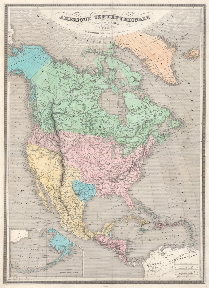
This is the 1845 Monin Map of North America highlighted the Republic of Texas and the Oregon Question. It highlights many of the most pressing political and international topics of the time: recognition of the Republic of Texas, the Oregon Question, and the westward expansion of the United States, all on the eve of the Mexican-American War (1846 - 1848).
A Closer Look
Starting with The Republic of Texas is highlighted in blue with its most conservative borders, as officially approved by France, limited by the Red River on the northern and Nueces River on the west. Within the United States, Louisiana, Arkansas, and Missouri are the westernmost states. Illinois only has an eastern border, with its western border approximated by rivers (although unmarked) and its northern border with Wisconsin lacking. Major cities and some towns are identified. Monin delineates no other states or territories between Missouri and the 'Oregon District' but identifies Native American tribes, including the Huron, Sioux, Osage, Ozark, and Mandan. Alaska is labeled as 'Russian America', as it was not yet part of the United States (it was bought from Russia in 1867). An inset of the Aleutian Islands and the Bering Sea occupies the lower left.Illustrating the Oregon Question
Intriguingly, while Monin recognizes the Republic of Texas, he does not support the U.S.'s claim to British Columbia, the so-called 'Oregon Question'. Instead, he depicts Canada dipping below the 49th parallel (the current U.S.-Canada border) into the 'Oregon District'. Very little political detail appears in Canada, labeled here at 'Nouvelle Bretagne' ('New Britain'). Rivers and lakes abound, and First Nations are referenced throughout.Republic of Texas
The Republic of Texas was a short-lived nation established in March 1836 when it seceded from Mexico. Following the independence of Mexico from Spain, the American Stephen Fuller Austin led a group of 300 Empresarios to settle Texas, near Austin, where they received a grant from the Mexican government. As more Americans moved to Texas, resentment and strife began to build between the American settlers and Mexican authorities. This and other factors ultimately led to the Texan Revolution in 1835 and the declaration of Texan independence in 1836. Texas remained an independent republic until it joined the United States ten years later in 1846.Texas Borders
The borders of the Republic of Texas were in dispute from the earliest days of the Texan Revolution. The Republic-claimed borders followed the Treaties of Velasco between the newly created Texas Republic and Mexican leader, Antonio López de Santa Anna. The treaties established an eastern boundary following the 1819 Adams-Onís Treaty between the United States and Spain, which established the Sabine River as the eastern boundary of Spanish Texas and the western boundary of the Missouri Territory. The Republic's southern and western boundary with Mexico was more nuanced. Texas claimed the Rio Grande del Norte as its western and southernmost border, while Mexico argued for a boundary much further east at the Nueces River. When Texas was annexed into the United States, the agreement followed the Republic claimed boundary, thus absorbing Mexican-claimed territory as far west as Santa Fe. This escalated tensions between the United States, the former Republic of Texas, and Mexico, ultimately triggering the Mexican-American War (1846 -1848).France Recognizes the Republic of Texas
When Texas seceded from Mexico on April 21, 1836, it immediately sought legitimacy through diplomatic appeals to major world powers - most of which were in Europe. Most European powers were reluctant to recognize the self-proclaimed Republic until it became clear that it could survive and what diplomatic ramifications, if any, formal recognition might yield. Nonetheless, France under King Louis Philippe recognized Texas on September 25, 1839. This act may have been partially trade inspired, and partially motivated by French antipathy towards Mexico following the First French Intervention or Pastry War (1838 - 1839). Recognizing Texas diplomatically allowed France to open official trade channels, particularly for cotton, a vital commodity in Europe and an increasing cause of tension between France and Britain. Moreover, the recognition of Texas accelerated the destabilization of Mexico, increasing the probability that any colonial aspirations the French may have had in seizing California would be successful.54-40 or Fight! American Claims to British Columbia
Following the transcontinental crossing of North America by the British Northwest Company sponsored explorer Alexander MacKenzie (1792 – 1793), and the American expedition of Lewis and Clark up the Missouri to the mouth of the Columbia River (1804 – 1806), it became apparent that control of the fur and resource-rich Pacific Northwest would bring great wealth and power to whoever could assert sovereignty. The American tycoon John Jacob Astor, with the permission of President Thomas Jefferson, was the first to attempt a permanent trading colony in the region, founding Astoria on the Columbia River in 1811. This quickly led to a confrontation with the established British-Canadian Northwest Company over this valuable territory. Americans in the 1820s through the 1840s argued that most of the Pacific Northwest should be part of the United States as a legacy of the 1803 Louisiana Purchase. England, on the other hand, argued for residual claims to the region derived from the MacKenzie Expedition and its fur trading empires: The Northwest Company and the Hudson Bay Company. The Oregon Dispute, as it came to be known, became an important geopolitical issue between the British Empire and the United States, especially after the War of 1812. Americans adopted the slogan '54-40 or Fight!' until the Oregon Question was finally resolved roughly along the current border by the 1846 Oregon Treaty.Publication History and Census
This map was created by Charles V. Monin and published in 1845 by Auguste Logerot. We note a single cataloged example, located at the Bibliothèque nationale de France.CartographerS
Charles V. Monin (1830 - 1880) was a French map publisher working the early to mid 19th century. A progressive printer, Monin was one of the first cartographic printers in Europe to take advantage of the newly discovered lithographic engraving process. His workshops in Paris and Caen, France, produced three important atlases as well as numerous independent issue maps. Monin was a member of La Sociéte de Géographie in Paris. He is known to have worked with other French map publishers including Vuillemin and Fremin. More by this mapmaker...
Auguste Logerot (fl. c. 1839 - c. 1880) was a French map and general interest publisher active throughout the mid to late 19th century. A. Logerot worked with other French publishers, cartographers and engravers of the period including Fremin, Dufour, Dyonnet, and Vuillemin. He published a large corpus of map and geographical atlases, though few of his map represented unique or exceptionally interesting work. This exception are his wonderful jigsaw puzzle maps - a style popular in 19th century France. Jigsaw puzzle maps are a kind of educational map printed on board and carved up in puzzle format. Logerot's imprint is frequently misprinted as Lagerot or Logeret. Logerot shared offices with several other publishers, printers and engravers at Quai des Augustins 55, Paris. Little else is known of Logerot's life and work. Learn More...
Condition
Good. Closed tears extending 1.75 and 3.75 inches into printed area, affecting only border and Atlantic. Light wear along original centerfold.
References
Bibliothèque nationale de France, département Cartes et plans, GE C-7925.