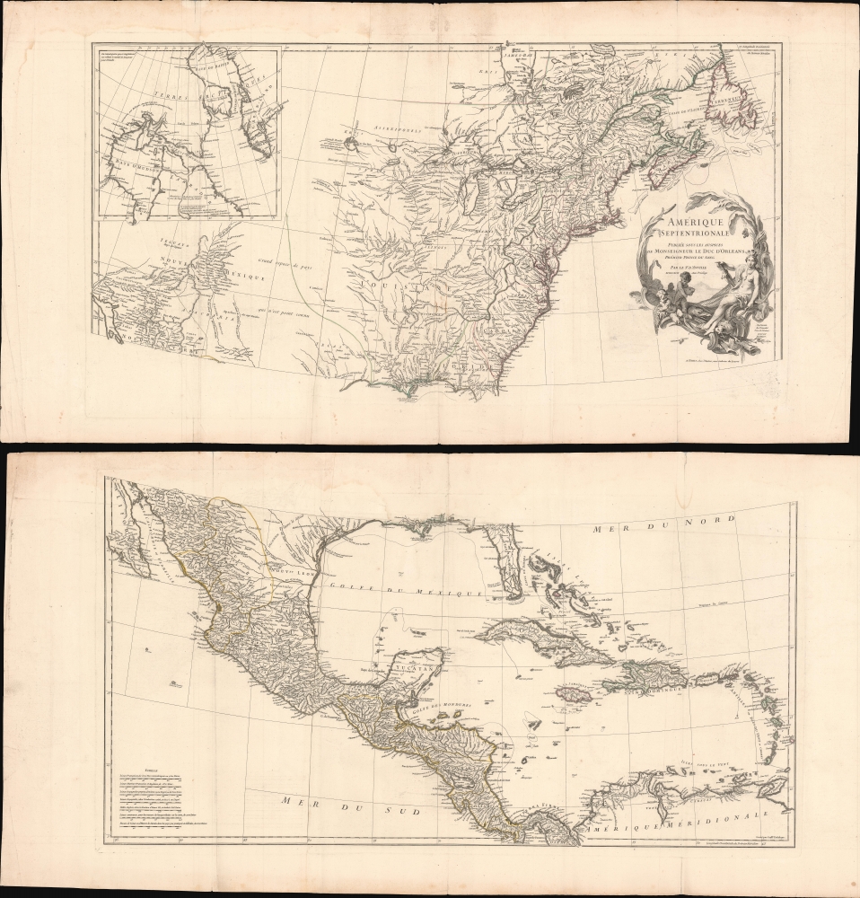
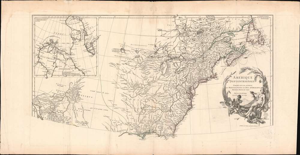
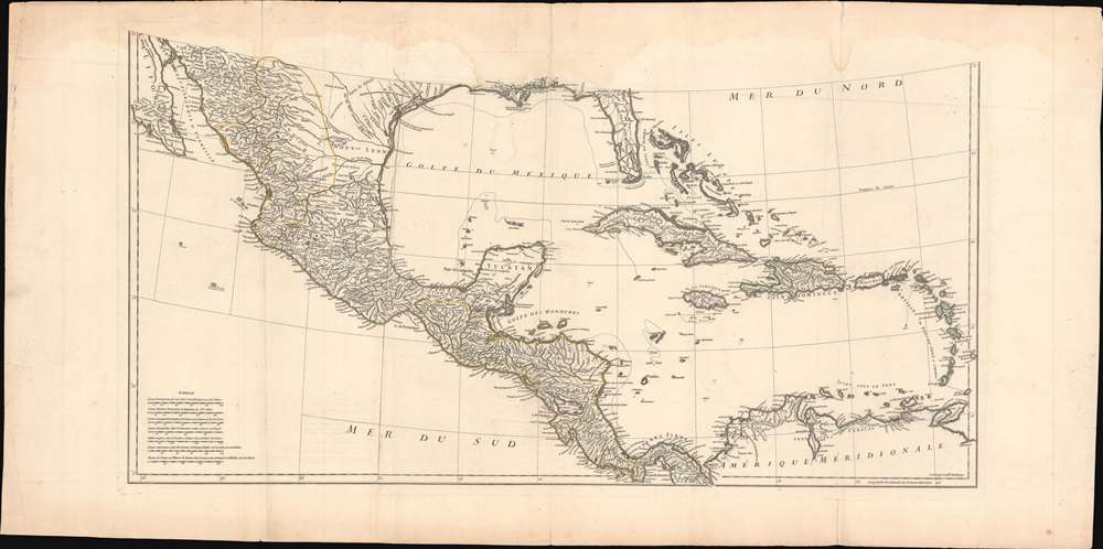
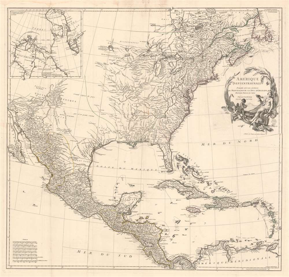
1746 D'Anville Wall Map of North America
AmeriqueSeptentrionale-anville-1746$1,800.00


Title
Amérique Septentrionale.
1746 (dated) 35 x 35 in (88.9 x 88.9 cm) 1 : 6200000
1746 (dated) 35 x 35 in (88.9 x 88.9 cm) 1 : 6200000
Description
This is the 1746 wall map of North America composed by Jean-Baptiste Bourguignon d'Anville, considered the finest French map of North America predating the French and Indian War (1754 - 1763). Nearly a century of French mapmaking and exploration in North America preceded this work, granting the map precedence, longevity, and a lasting influence. It was copied by Thomas Jefferys as the basis for his own 1755 map of North America. More than half a century later, it was among the maps consulted by Nicholas King for his seminal manuscript map of western North America compiled for the Lewis and Clark expedition.
A Closer Look
The map broadly embraces the known parts of North America, Central America, and the West Indies, providing the greatest detail to the east of the Mississippi, in Central America, along the Mexican coast as far as Baja, and inland along the Rio Grande (Rio del Norte) as far as modern-day New Mexico. Characteristically, D'Anville has left the Transmississippi, Great Plains, Texas, and the Arctic largely blank, underscoring the general unexplored state of those lands.American Indian Knowledge
In drawing the map, D'Anville made heavy use of reports of Native American cartographic knowledge collected by French missionaries, military officers, fur traders, and explorers in the Upper Mississippi and Great Lakes. There are numerous instances, such as the river connection between the Lake of the Woods and Lake Winnipeg (which, though not shown, is alluded to textually as 'Assenipoel Great Lake'), where D'Anville's cartography specifically cites indigenous groups, in this case the Assenipoel and the Oshagac. Similarly, D'Anville notes American Indian groups and villages throughout the Lower Mississippi Basin.Teguayo
The Teguayo Nation appears in the largely unknown region to the west of Santa Fe. Teguayo was identified as one of the Kingdoms of Gold presumed to be found in the unexplored American West. The term 'Teguayo' first appears in the Benevides Memorial, where it is described as a kingdom of great wealth to rival Quivara, another mythical kingdom that curiously does not appear here. The idea was later popularized in Europe by the nefarious Spaniard and deposed governor of New Mexico, Diego Dionisio de Peñalosa Briceño y Berdugo (1621 - 1687), who, imagining himself a later day Pizzaro, promoted the Teguayo legend to the royalty of Europe. Originally, Teguayo was said to lie west of the Mississippi and north of the Gulf of Mexico, but for some reason, D'Anville situates it considerably further west.Hudson Bay
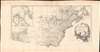
A large inset in the upper left focuses on Hudson Bay. This area was of considerable interest to both the French and the British, who believed that somewhere in the region a naval passage to the Pacific could be discovered - the legendary Northwest Passage. Unlike the Spaniards in Mexico, neither the French nor the British had a practical route to the Pacific and thus access to the rich Asia trade from their colonies in North America, so finding such a route was of paramount importance. Today, due to Global Warming, a Northwest Passage does exist, but the efforts of early navigators to search for it invariably ended in tragedy.Publication History and Census
The present map is the first edition, published in 1746. The map was drawn by J. B. B. D'Anville and engraved in Paris by Guillaume Delahaye. The cartouche was designed by Sr. Gravelot and engraved by Sr. Major. The map appears both as a separate issue and in various D'Anville and composite atlases. Well represented institutionally but uncommon on the market in the first edition.CartographerS
Jean Baptiste Bourguignon d'Anville (1697 - 1782) was perhaps the most important and prolific cartographer of the 18th century. D'Anville's passion for cartography manifested during his school years when he amused himself by composing maps for Latin texts. There is a preserved manuscript dating to 1712, Graecia Vetus, which may be his earliest surviving map - he was only 15 when he drew it. He would retain an interest in the cartography of antiquity throughout his long career and published numerous atlases to focusing on the ancient world. At twenty-two D'Anville, sponsored by the Duke of Orleans, was appointed Geographer to the King of France. As both a cartographer and a geographer, he instituted a reform in the general practice of cartography. Unlike most period cartographers, D'Anville did not rely exclusively on earlier maps to inform his work, rather he based his maps on intense study and research. His maps were thus the most accurate and comprehensive of his period - truly the first modern maps. Thomas Basset and Philip Porter write: "It was because of D'Anville's resolve to depict only those features which could be proven to be true that his maps are often said to represent a scientific reformation in cartography." (The Journal of African History, Vol. 32, No. 3 (1991), pp. 367-413). In 1754, when D'Anville turned 57 and had reached the height of his career, he was elected to the Academie des Inscriptions. Later, at 76, following the death of Philippe Buache, D'Anville was appointed to both of the coveted positions Buache held: Premier Geographe du Roi, and Adjoint-Geographer of the Academie des Sciences. During his long career D'Anville published some 211 maps as well as 78 treatises on geography. D'Anville's vast reference library, consisting of over 9000 volumes, was acquired by the French government in 1779 and became the basis of the Depot Geographique - though D'Anville retained physical possession his death in 1782. Remarkably almost all of D'Anville's maps were produced by his own hand. His published maps, most of which were engraved by Guillaume de la Haye, are known to be near exact reproductions of D'Anville' manuscripts. The borders as well as the decorative cartouche work present on many of his maps were produced by his brother Hubert-Francois Bourguignon Gravelot. The work of D'Anville thus marked a transitional point in the history of cartography and opened the way to the maps of English cartographers Cary, Thomson and Pinkerton in the early 19th century. More by this mapmaker...
Guillaume-Nicolas Delahaye (1725 - February 24, 1802) was the most prolific member of the Delahaye (De-La-Haye) family of engravers active in Paris throughout the 18th century. Given that the name, Delahaye literally translates to 'of the Hague' it can be assume they were French Huguenots who were forced to flee the Netherlands under threat of religious persecution. Born in Paris, he was the son of patriarch Jean-Baptiste Delahaye and brother to Jean-Baptistie-Henri Delahaye. It is said that his godfather, who held him at the baptismal font, was none other than the famous french cartographer Guillaume de L'Isle. The Delahaye family engraved for many of the great cartographers of 18th century Paris, including Jean-Baptiste Bourguignon d'Anville, Didier Robert de Vaugondy, Jean-Baptiste de Mannevillette, and Jean-Nicolas Buache, among others. He was awarded the public office Premier Graveur du Roi and worked on a series of maps illustrating the king's hunts around Versailles. Guillaume also worked with foreign cartographers such as Tomas Lopez of Madrid. Possibly Delahaye's most significant map is A Map of the Country between Albemarle Sound and Lake Erie prepared for the memories of Thomas Jefferson. He married in 1758. In total he engraved some 1200 maps. Delahaye died in Charenton. In 1792, his daughter, Antoinette Marie Delahaye (1773-1857), married the geographer Jean-Denis Barbie du Bocage. Learn More...
Condition
Good. Some slight dampstaining in the upper margins. A few verso reinforcements to old fold lines. Two panels, as issued. Can be joined on request. Individual sections measure 22 x 44 inches, edge to edge. The final photo above is a hypothetical composite, for which the printed image area would be about 35 x 35 inches, plus margins.
References
OCLC 68766720.