This item has been sold, but you can get on the Waitlist to be notified if another example becomes available, or purchase a digital scan.
1926 Admiralty Nautical Chart of the East China Sea from Taiwan to Japan
AmoyNagasaki-admiralty-1926$600.00

Title
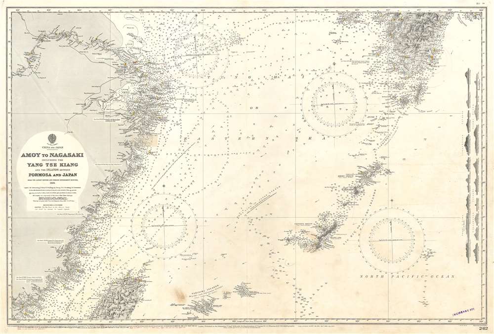
Amoy to Nagasaki Including the Yang Tse Kiang and the Islands Between Formosa and Japan.
1928 (dated) 26.75 x 39.25 in (67.945 x 99.695 cm) 1 : 1600000
1928 (dated) 26.75 x 39.25 in (67.945 x 99.695 cm) 1 : 1600000
Description
This is a 1926 British Admiralty nautical chart or maritime map of the East China Sea. The map depicts the region from Nanking (Nanjing) and Shanghai, China to Kyushu and from Nagasaki, Japan to Taiwan / Formosa. Highly detailed, myriad depth soundings are indicated throughout, with the highest concentrations along the Chinese and Japanese coastlines, in the Formosa Strait, and encircling the numerous islands between Kyushu and Taiwan. Depth soundings are also present along high-traffic shipping routes, and along the Yangtze River past Nanjing. Innumerable cities, towns, and villages are labeled throughout, including Shanghai, Hangzhou, Nanjing, Nagasaki, and Kagoshima. Extreme detail is paid to the Okinawa Group, the Amami Groupand the Linschoten Islands, three island groups between Kyushu, the southernmost of the Home Islands of Japan, and Taiwan.
Manuscript Annotations
Numerous manuscript notations are present on this chart and are done in red ink. The creator of these notations traced their addition to the chart in much the same fashion as the Admiralty traced its small corrections, giving the year (manuscript additions were made in 1928, 1929, 1930, 1931, 1932, 1933, and 1934), and location of the change. A highly detailed paste-down, situated near Ningbo, appears to have been printed in the same style as the rest of the chart.Census and Publication History
This chart was engraved by Edward Weller and published by the British Admiralty in 1926. The first edition of the chart was published by the Admiralty on August 1, 1891, with what appears to be dozens of small and large corrections undertaken for the editions published in the intervening years. Three records for the 1891 edition of this chart appear in the OCLC, but no institutional holdings are cited in any of them. A fourth record for the 1915 edition of this chart appears in the OCLC as well, with one institution cited as holding it in their collection.CartographerS
The British Admiralty Office (1795 - Present) or the United Kingdom Hydrographic Office refers to the Branch of the English government that is responsible for the command of the British Navy. In 1795 King George III created the United Kingdom Hydrographic Office, known in short as the U.K.H.O., to provide top notch nautical charts to the vast Royal Navy. Prior the founding of the Admiralty the surveying and creation of nautical charts was primarily a commercial venture wherein the cartographer himself, more of than not, actually financed the printing of his own material. The great navigator Cook himself is known to have scrambled for funds to publish his own seminal charts - the most important and advanced of the period. The system of privately funded nautical mapping and publishing left vast portions of the world uncharted and many excellent charts unpublished. King George III, responding significant loss in trade revenue related to shipwrecks and delay due to poor charts, recognized the need for an institutionalized government sponsored cartographic agency - the Admiralty. The first head of the Admiralty, a position known as Hydrographer, was the important cartographer Alexander Dalrymple. Dalrymple started by organizing and cataloging obtainable charts before initiating the laborious process of updating them and filling in the blanks. The first official Admiralty Chart appeared in 1800 and detailed Quiberon Bay in Brittany. By 1808 the position of Hydrographer fell to Captain Thomas Hurd. Hurd advocated the sale of Admiralty charts to the general public and, by the time he retired in 1829, had issued and published some 736 charts. Stewardship of the organization then passed to Rear Admiral Sir Francis Beaufort. It was under Beaufort's administration that the Admiralty truly developed as a "chart making" as opposed to a "chart cataloging" institution. Beaufort held his post from 1829 to 1854. In his 25 years at the Admiralty Beaufort created nearly 1500 new charts and sponsored countless surveying and scientific expeditions - including the 1831 to 1836 voyage of the H.M.S. Beagle. By 1855 the Admiralty's chart catalog listed some 1,981 charts. More by this mapmaker...
Edward Weller (July 1, 1819 - 1884) was a cartographer and engraver based in London. Weller was a nephew of another well-known map publisher Sidney Hall (1788 - 1831), who gave him 50 Pounds to pay his apprenticeship fees. He engraved for many prominent mapmakers and was active enough in the community to be recommended for membership to the Royal Geographical Society in 1851 on the recommendation of John Arrowsmith, among others. He eventually inherited the Sidney Hall map business which led him to follow Arrowsmith as the unofficial geographer to the Royal Geographical Society. Weller was among the first map printers in London to embrace lithography. His best known work appears in Cassell's Weekly Dispatch Atlas, published in monthly segments for subscribers of the 'Weekly Dispatch' newspaper. This collection of maps eventually grew to include much of the known world. Published in various editions from 1855 through the early 1880s. Weller died in May of 1884, leaving behind a successful business and an unhappy widow. His son, Francis Sidney Weller (1849 - 1910), followed in his father's footsteps and continued the family map business. The atlas Mackenzie's Comprehensive Gazetteer of England and Wales was published in 1894 and bore F. S. Weller's signature on the maps. Learn More...
Condition
Very good. Even overall toning. Light soiling. Blank on verso.
References
OCLC 39881096 (1915 edition).