This item has been sold, but you can get on the Waitlist to be notified if another example becomes available, or purchase a digital scan.
1668 Sanson Map of Ancient Europe
AncientEurope-sanson-1668$325.00

Title
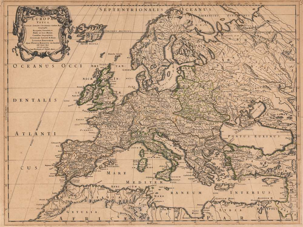
Europa Vetus Nicolai Sanson Christianiss. Galliar. Regis Geographi..
1668 (dated) 15.5 x 22 in (39.37 x 55.88 cm) 1 : 12000000
1668 (dated) 15.5 x 22 in (39.37 x 55.88 cm) 1 : 12000000
Description
This is Nicolas Sanson's 1668 map of Europe, in a very attractive contemporary color example. The map combines modern topography with toponymy drawn from classical geographers. Sanson, a historian as well as a cartographer, intended this map to illustrate Europe as it was understood in the days of Imperial Rome. Thus the topography of the map reflects seventeenth-century cartography, while the political divisions and place names are drawn from the cartographers of antiquity: Claudius Ptolemy, Pomponius Mela, and Solinus, among others. The northern limits of the Roman Empire, along the Danube River and the Rhine, are marked with a dotted line and emphasized with outline color.
Publication History and Census
This map was issued separately in 1668, although examples were also added to made-to-order atlases published by Sanson and Pierre Mariette. The map is well represented in institutional collections.CartographerS
Nicolas Sanson (December 20, 1600 - July 7, 1667) and his descendants were the most influential French cartographers of the 17th century and laid the groundwork for the Golden Age of French Cartography. Sanson was born in Picardy, but his family was of Scottish Descent. He studied with the Jesuit Fathers at Amiens. Sanson started his career as a historian where, it is said, he turned to cartography as a way to illustrate his historical studies. In the course of his research some of his fine maps came to the attention of King Louis XIII who, admiring the quality of his work, appointed Sanson Geographe Ordinaire du Roi. Sanson's duties in this coveted position included advising the king on matters of geography and compiling the royal cartographic archive. In 1644, he partnered with Pierre Mariette, an established print dealer and engraver, whose business savvy and ready capital enabled Sanson to publish an enormous quantity of maps. Sanson's corpus of some three hundred maps initiated the golden age of French mapmaking and he is considered the 'Father of French Cartography.' His work is distinguished as being the first of the 'Positivist Cartographers,' a primarily French school of cartography that valued scientific observation over historical cartographic conventions. The practice result of the is less embellishment of geographical imagery, as was common in the Dutch Golden Age maps of the 16th century, in favor of conventionalized cartographic representational modes. Sanson is most admired for his construction of the magnificent atlas Cartes Generales de Toutes les Parties du Monde. Sanson's maps of North America, Amerique Septentrionale (1650), Le Nouveau Mexique et La Floride (1656), and La Canada ou Nouvelle France (1656) are exceptionally notable for their important contributions to the cartographic perceptions of the New World. Both maps utilize the discoveries of important French missionaries and are among the first published maps to show the Great Lakes in recognizable form. Sanson was also an active proponent of the insular California theory, wherein it was speculated that California was an island rather than a peninsula. After his death, Sanson's maps were frequently republished, without updates, by his sons, Guillaume (1633 - 1703) and Adrien Sanson (1639 - 1718). Even so, Sanson's true cartographic legacy as a 'positivist geographer' was carried on by others, including Alexis-Hubert Jaillot, Guillaume De L'Isle, Gilles Robert de Vaugondy, and Pierre Duval. More by this mapmaker...
Pierre Mariette (1569 - 1657) was a French publisher and engraver active in Paris during the first half of the 19th century. Mariette established himself as successful publisher of art prints, but decided to turn his energy to cartography with the purchase of the plates for Melchior Tavernier's maps in 1644. Tavernier had partnered with Sanson before his death and Mariette followed suit. Around 1644- 1648 Mariette partnered with Nicolas Sanson, a then nascent figure in French cartography, to produce folio maps and atlases. The Sanson-Mariette relationship depended upon Sanson to draw and obtain rights for the maps while Mariette engraved them and paid for the expensive printing process. The two then shared rights to the maps into perpetuity. The finished copper plates were split between two such that neither could publish an atlas without the other's assent. The relationship seemed reasonably amicable until Mariette's death in 1657, when disputes arose between Sanson and Mariette's heirs. A court battle finally returned the most of the plates to Sanson's own heirs in 1674. As a consequence, some printings feature the Mariette imprint, others the Sanson imprint, and still others both imprints. Learn More...
Condition
Very good. Margin extended at top with very small area of manuscript reinstatement of border. Original outline color.
References
OCLC 633244278.