This item has been sold, but you can get on the Waitlist to be notified if another example becomes available, or purchase a digital scan.
1782 Delisle de Sales Map of Ancient Persia Divided into 20 Provinces (Persian Empire)
AncientPersia-sales-1782$100.00

Title
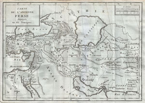
Carte de l'Ancienne Perse Divisee en XX. Satrapies.
1782 (undated) 9 x 13 in (22.86 x 33.02 cm) 1 : 12500000
1782 (undated) 9 x 13 in (22.86 x 33.02 cm) 1 : 12500000
Description
This is a rare 1782 map of ancient Persia by Jean- Baptiste-Claude Delisle de Sales. The map covers the lands of the First Persian Empire as divided into 20 Satrapies or provinces from Turkey and the Mediterranean Sea, east as far as modern day Afghanistan. Includes the Black Sea, the Persian Gulf, the Red Sea and a rather bulbous Caspian Sea. The map notes several rivers, lakes, cities and towns, as well as topographical features, with mountains rendered in profile.
Founded by Cyrus the Great in the 6th century BCE, the First Persian Empire or the Achaemenid Empire was, at its height, the biggest Empire in the world. Cyrus appointed twenty Satraps or provincial administrators, identified in this map. These Satraps ruled in the name of the king, thus making it possible to rule over the entire territory.
This map was issued as part of Delisle de Sales' Histoire des Hommes. Partie de l'Histoire Moderne. This volume is exceedingly rare as most of Sales' work was burnt under the censorship of heresy.
Cartographer
Jean-Baptiste-Claude Delisle de Sales or Jean-Baptiste Isoard de Lisle (1741–1816) was a French philosopher, historian, and accused heretic active in the late 18th century. Sales is best known for his publication of the multi-volume opus The Philosophy of Nature: Treatise on Human Moral Nature. The work, among other ideas, challenged the Biblical theory that the earth was created in 4004 BC. Instead, Sales put forth the theory based upon astronomical observations, that the earth was 140,000 years old. Sales' revolutionary ideas caused him to be declared a heretic by the Catholic Church. His publications were subsequently censored and, for the most part, destroyed. As a consequence all of his works are today extremely rare. Sales was also, notably, a close friend of Voltaire who in 1777 visited him in prison, gifting him 500 pounds towards his release. Delisle de Sales is unrelated to the more famous De L'Isle family of cartographers. More by this mapmaker...
Source
Delisle de Sales, Histoire des Hommes. Partie de l'Histoire Moderne, (Paris) 1782.
Condition
Very good. Minor wear along original fold lines. Original platemark visible. Blank on verso.