This item has been sold, but you can get on the Waitlist to be notified if another example becomes available, or purchase a digital scan.
1876 Owen Map of Ancient Native American Ruins in the American Southwest
AncientRuins-owen-1876$237.50

Title
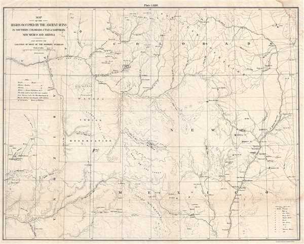
Map of the Region Occupied by the Ancient Ruins in Southern Colorado, Utah and Northern New Mexico and Arizona. Also Showing the Location of Most of the Modern Pueblos.
1876 (undated) 19.5 x 24.5 in (49.53 x 62.23 cm) 1 : 760320
1876 (undated) 19.5 x 24.5 in (49.53 x 62.23 cm) 1 : 760320
Description
This is an 1876 F. D. Owen map of the ancient Native American ruins in the American Southwest. The map depicts the Four Corners region from southern Utah and Arizona to Colorado and New Mexico. Ruins are present throughout the region, with the largest concentration existing in southwestern Colorado around Mesa Verde and Sierra La Late. Today, Mesa Verde is a national park with over 4,300 sites, including 600 cliff dwellings, such as Cliff Palace, the largest cliff dwelling in North America. Ancestral Puebloans called the pueblos at Mesa Verde home from 550 A.D. to 1300 A. D. Chaco Canyon, known today as Chaco Culture National Historical Park, is also depicted. Situated in New Mexico, the ruins are numerically labeled and a table, located in the lower left corner, provides the names of the pueblos. Ancestral Puebloans inhabited the Chaco Canyon region between 900 A. D. and 1150 A. D. Myriad streams, creeks, and rivers are illustrated, including the Rio Grande, several of the rivers are flanked by ruins. Numerous cities are labeled, including Alamosa and Del Norte in Colorado, and Alameda and Albuquerque in New Mexico.
This map was drawn by F. D. Owen in 1876 and published by the American Photo-Lithographic Company.
This map was drawn by F. D. Owen in 1876 and published by the American Photo-Lithographic Company.
Cartographer
Frederick D. Owen (1871 - January 28, 1931) was an American cartographer, engineer, and architect active in Washington D.C. in the late 19th and early 20th centuries. Owen was born in Connecticut, Owen was a civilian contractor with the U.S. Bureau of Topographical Engineers. He worked with the First Lady Caroline Harrison (1832 - 1892), wife of President Benjamin Harrison, to plan an ambitious expansion of the White House, but it was never realized. Seven of his maps are located in the Library of Congress. He created the maps that hung in the ‘War Room’ at the White House during the Spanish-American War (‘Frank Leslie’s Popular Monthly’, Vol. L, No. 2, 113.). Later, Owen worked for the Washington D.C. Parks department. More by this mapmaker...
Condition
Very good. Soiling to upper right and lower right corners which minimally effects the printed area. Backed on tissue. Blank on verso.
References
OCLC 367536889.