
This item below is out of stock, but another example (left) is available. To view the available item, click "Details."
Details
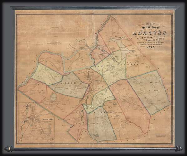
1852 Walling Map of Andover, Massachusetts
1852 (dated) $2,000.00
1852 Walling Map of Andover, Massachusetts
Andover-walling-1852$1,250.00

Title
Map of the Town of Andover, Essex County, Massachusetts.
1852 (dated) 39 x 43 in (99.06 x 109.22 cm) 1 : 18000
1852 (dated) 39 x 43 in (99.06 x 109.22 cm) 1 : 18000
Description
This is a scarce 1852 Henry F. Walling wall map of the towns of Andover and North Andover, Massachusetts. Like most Walling town maps, the cartographer has taken great pains to identify the homes of individual families and landowners, as well as important roads, rail lines, municipal buildings, and businesses. Walling sold his maps by subscription, often going door to door, so the presence of individual property owners was doubtless intended as an enticement to buyers.
Andover is the site of Phillips Academy, an elite co-educational university-preparatory boarding school founded in 1778. The current location of Phillips Academy identified here as such just south of 'Andover Theological Seminary' in the village map inset.
There is no record of how many examples of this map were produced, but today it is quite rare.
Cartographer
Henry Francis Walling (June 11, 1825 - April 8, 1889) was an American civil engineer, cartographer, surveyor, and map publisher active from the middle to late 19th century. Walling was born in Providence, Rhode Island. He studied/worked at the Providence Athenaeum before discovering a talent for mathematics and surveying. Walling took a position with Samuel Barrett Cushing (1846 - 1888), a Providence-based civil engineer with whom he issued in 1846 a revision of James Steven's Topographical Map of the State of Rhode-Island. Walling established himself independently around 1850 and immediately began preparing a series of town plans focusing on Bristol County, near Providence. Buoyed by widespread interest in his plans, Walling expanded his operations to Massachusetts, where, by 1857, he had produced no less than 50 town plans. Apparently, Walling's business model involved a contract with town officials to produce a certain number of maps, after which he acquired the right to print and sell additional copies on his own account. This work eventually led to Walling's appointment as Massachusetts "Superintendent of the State Map", a designation that began appearing on his maps around 1855. While Walling's work focused heavily on city and county maps, he successfully published three scarce state maps: Maine, Vermont, and Rhode Island. In 1856, Walling relocated his headquarters to New York City, where he had better access to quality lithographers. The Civil War (1861 - 1865) proved difficult for Walling, and diminished sales may have forced him into a partnership with Ormando W. Gray, with whom he published numerous state, county, and national atlases in the 1860s and 1870s. Around 1880, Walling took a post with the U.S. Coast Survey, with whom he worked on various charts until requesting a transfer in 1883 to the newly formed U.S. Geological Survey. Walling remained with the Geological Survey until his untimely death of a heart attack in April 1889. More by this mapmaker...
Condition
Very good. Full professional restoration. Backed on linen. Attached to rollers which add four inches to the height and five inches to the width.
References
OCLC 40836458.