1852 Walling Map of Andover, Massachusetts
Andover-walling-1852-2$2,000.00


Title
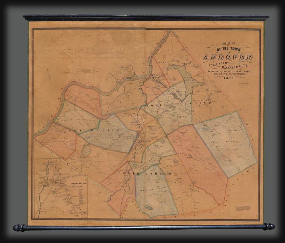
Map of the Town of Andover, Essex County, Massachusetts.
1852 (dated) 39 x 43 in (99.06 x 109.22 cm) 1 : 18000
1852 (dated) 39 x 43 in (99.06 x 109.22 cm) 1 : 18000
Description
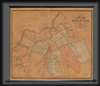
This is a scarce 1852 Henry F. Walling wall map of Andover and North Andover, Massachusetts. Like most Walling town maps, the cartographer has taken great pains to identify the homes of individual families and landowners, as well as important roads, rail lines, municipal buildings, and businesses. Walling sold his maps by subscription, often going door to door, so the presence of individual property owners was doubtless intended as an enticement to buyers. Both Phillips Andover Academy and the Andover Theological Seminary are identified in the inset in the lower left.
Phillips Andover Academy
Phillips Academy was founded in 1778, during the American Revolutionary War, by Samuel Phillips, marking it as the oldest incorporated secondary school in the United States. For a time, the school shared its campus with the Andover Theological Seminary (founded in 1807), discussed below. In 1973, Phillips Andover merged with the Abbott Female Seminary to become a co-educational academy. Today, Phillips Andover remains a prestigious secondary school with distinguished alumni, including George Bush presidents, Frederick Law Olmsted, Humphrey Bogart, and Edgar Rice Burroughs, among many others. The current location of Phillips Academy is identified here as just south of 'Andover Theological Seminary' in the village map inset.Andover Theological Seminary
Established in 1807, Andover Theological is the first and thus the oldest theological seminary founded in the United States. When it was founded, it shared a campus with Phillips Andover (founded in 1778), but later, the two separated. The Congregationalist seminary emerged from the Unitarian Controversy, a split between liberal and orthodox Calvinists at Harvard. Harvard embraced the more liberal point of view, leading to the founding of Andover for 'Old Calvinists.' The seminary merged with Newton Theological in 1965 and operates today as the Andover Newton Seminary at Yale Divinity School.Publication History and Census
This map was created and published by Henry F. Walling in 1852 and lithographed by Augustus Kollner. We note 7 examples cataloged in OCLC, which are part of the collections at the New York Public Library, Harvard University, the Boston Athenaeum, the State Library of Massachusetts, the Peabody Essex Museum, the Osher Map Library at the University of Southern Maine, and the University of Virginia. There is no record of how many examples of this map were produced, but today it is quite rare.CartographerS
Henry Francis Walling (June 11, 1825 - April 8, 1889) was an American civil engineer, cartographer, surveyor, and map publisher active from the middle to late 19th century. Walling was born in Providence, Rhode Island. He studied/worked at the Providence Athenaeum before discovering a talent for mathematics and surveying. Walling took a position with Samuel Barrett Cushing (1846 - 1888), a Providence-based civil engineer with whom he issued in 1846 a revision of James Steven's Topographical Map of the State of Rhode-Island. Walling established himself independently around 1850 and immediately began preparing a series of town plans focusing on Bristol County, near Providence. Buoyed by widespread interest in his plans, Walling expanded his operations to Massachusetts, where, by 1857, he had produced no less than 50 town plans. Apparently, Walling's business model involved a contract with town officials to produce a certain number of maps, after which he acquired the right to print and sell additional copies on his own account. This work eventually led to Walling's appointment as Massachusetts "Superintendent of the State Map", a designation that began appearing on his maps around 1855. While Walling's work focused heavily on city and county maps, he successfully published three scarce state maps: Maine, Vermont, and Rhode Island. In 1856, Walling relocated his headquarters to New York City, where he had better access to quality lithographers. The Civil War (1861 - 1865) proved difficult for Walling, and diminished sales may have forced him into a partnership with Ormando W. Gray, with whom he published numerous state, county, and national atlases in the 1860s and 1870s. Around 1880, Walling took a post with the U.S. Coast Survey, with whom he worked on various charts until requesting a transfer in 1883 to the newly formed U.S. Geological Survey. Walling remained with the Geological Survey until his untimely death of a heart attack in April 1889. More by this mapmaker...
Augustus Theodore Frederick Köllner (1812 - December 10, 1906) was an artist, engraver, and lithographer based in Philadelphia. Born in Wurttemberg, Germany, Köllner began his career in Germany, working as a book illustrator in Stuttgart and Paris in the late 1820s and 1830s before immigrating to the United States in 1839. After settling in Washington, D.C., Köllner worked as a lithographer for the Haas firm, working on advertisements, bank notes, and city views. He moved to Philadelphia in 1840 and tried unsuccessfully to establish himself as a portrait painter. After this misstep, Köllner became the second chief artist of P.S. Duval and William Huddy's 'U.S. Military Magazine' (1839 - 1842). Throughout the 1840s, Köllner worked as a lithographer for many different Philadelphia based lithographic firms, including Duval, J.T. Bowen, Frederick Kuhl, Thomas Sinclair, and Wagner and McGuigan. Between 1847 and 1848, Köllner began working for the lithographic firm Brechemin and Camp, for whom he designed all genres of lithographs and advertised his own lithographic views based on his annual summer sketching trips along the East Coast. His work also began to be published in the seminal series 'View of American Cities', published between 1848 and 1851 by Goupil, Vibert, and Company. While working for Brechemin and Camp, Köllner was responsible for creating the multi-foot Dripp's map of New York City. Kollner established his own firm in 1851 and worked on a wide range of projects, including advertisements, labels, city and landscape views, and maps. During the Civil War, Köllner enlisted in the cavalry in 1863 and later sold photographic reproductions of the etchings he did as a soldier. He produced his last series of landscape lithographs entitled 'Bits of Nature' in 1878, but focused mostly on his watercolor work during the late 1870s. Köllner retired in the early 1880s, but continued to make sketching trips around the Philadelphia area. Köllner married Mary Sheek (c. 1821 - 1899) in 1843, and they had several children, three of which survived infancy: William, Clara, and Josephine. Köllner died on December 10, 1906. Learn More...
Condition
Very good. Full professional restoration. Accompanied by original rollers which add four inches to the height and five inches to the width.
References
OCLC 40836458.