
1939 Service Geographique Archaeological Map of Angkor, Cambodia

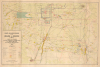

Carte Archéologique de la Région d'Angkor.
Preserving the Many Marvelous Temples of Angkor.
- Digital Map Information
- Suitable for large format printing
- File Size: 33.82 MB
- File Type: ZIP / TIFF
- ICC color profile embedded
- Delivered instantly via download link
Preserving the Many Marvelous Temples of Angkor.
This is a rare, large-format 1939 archaeological map of Angkor prepared by the Service géographique de l'Indochine. It reflects the culmination of years of surveying and conservation work by the École française d'Extrême-Orient in the early 20th century to document and understand the area's remarkable Khmer temple complexes.A Closer Look
The map covers from Angkor Wat and nearby temples and archaeological sites at top to Siem Reap and Bakong at bottom. Above Angkor Wat is an even larger moat enclosing the city of Angkor Thom, with its own temples and internal system of waterways and causeways. To the left and right of Angkor Thom are the remains of massive reservoirs (barays), which may have had a spiritual function in addition to or instead of a purely practical one (irrigation).A detailed legend at bottom-left including symbols and notation for both ancient and modern structures, including roads ranging from graveled (empierrée) imperial Khmer and local roads to Decauville ways (a sort of portable, pre-fabricated narrow-gauge railway) to paths. Earthworks, bridges, stonework, pagodas, steles, and other historic remnants of Angkor are also noted, as are modern structures (villages, thatched huts) and topographical features such as waterways. Additional features are labelled on the map, such as a school, hotel, and power plant in Siem Reap.
'Rediscovering' and Preserving Angkor
The Hindu-Buddhist temple of Angkor Wat in Cambodia is widely recognized as one of the greatest structures of premodern history and remains by far the largest religious structure in the world. However, it was only part of a much larger city, which may have been home to one million people at its height, and which contained a large number of temples, many of which are labeled here. The power of the Khmer Empire peaked between the 9th and 13th centuries in what is now northwestern Cambodia, utilizing a system that maximized the potential of the environment through careful and ingenious irrigation techniques. The mastery of water allowed for abundant rice harvests and a massive population that could engage in non-agricultural labor at least part of the year. Temples were carefully integrated with reservoirs (barays) and canals that sustained both agriculture and urban life, further demonstrating the sophistication of Khmer hydraulic engineering.Although much about the construction of Khmer temples remains uncertain, their course of evolution is fairly clear, from an earlier model exemplified by Bakong (at bottom-right) that established the basic 'temple-mountain' form, to the full realization of this form in the incredibly intricate and complex design of Angkor Wat, constructed in the early 12th century under King Suryavarman II. Angkor Wat was originally dedicated to the Hindu god Vishnu and designed as a vast, symbolically charged representation of Mount Meru (the center of the cosmos), with five soaring towers and an immense system of moats and causeways. Archaeologists still debate how such a massive complex could have been constructed in roughly thirty years, or how the huge sandstone blocks were fitted together so perfectly (no mortar was used).
Nearby, Angkor Thom, founded later in the 12th century by King Jayavarman VII, served as a fortified urban capital centered on the Bayon temple, famous for its serene, smiling stone faces that embody a distinctly Mahayana Buddhist vision of kingship and cosmology. Jayavarman VII is generally seen as the most powerful of all Khmer rulers, who built massive public works and committed tremendous resources to religious devotion (for example, one inscription from his era suggests that 80,000 people were committed to the upkeep of the temple at Ta Prohm, east of Angkor Thom). However, due to the rise of powerful new neighbors and perhaps climatic change that interrupted the vital monsoon rains, the last Khmer King, Ponhea Yat, shifted the capital to Phnom Penh in 1434 CE and Angkor was abandoned.
Many of the temples of Angkor fell into disuse and disrepair with the fall of the Khmer Empire. Angkor Wat was never fully abandoned as a religious site but did become overgrown, causing early European explorers to assume that they had stumbled on a lost monumental structure that surpassed anything in Europe and even a mysterious and extraordinary lost civilization. As French imperial interests in Southeast Asia expanded, French missionaries, naturalists, and explorers gained a better understanding of Angkor and its structures, and began efforts to clear overgrowth and preserve the temple sites.
In the early 20th century, systematic conservation and archaeological work at these sites was undertaken by the École française d'Extrême-Orient (EFEO), which played a decisive role in saving Angkor from further deterioration. Beginning in 1908, EFEO scholars and engineers introduced modern documentation, mapping, and stabilization techniques, and pioneered the method of anastylosis - carefully dismantling and reassembling collapsed structures using their original stone blocks, especially at monuments like Bakong and Banteay Srei. Their work transformed Angkor into an internationally recognized archaeological park (albeit one tied closely to French imperial prestige), laying the foundations for later conservation efforts and global appreciation of Khmer cultural heritage.
Publication History and Census
This map was prepared in 1939 by the Service géographique de l'Indochine, utilizing work done by the EFEO and the Aviation Militaire in addition to its own maps. It is cataloged among the holdings of fourteen institutions worldwide in the OCLC but appears only occasionally on the market.Cartographer
Service Géographique de l'Indochine (1899 - c. 1954) was created by decree on July 5, 1899. A Lieutenant Colonel Lubanski, from the Service Géographique de l'Armée, was put in charge. He along with several other army officers, as well as trained topographers and other geographers, immediately began applying the cutting-edge scientific practices employed by the Service Géographique de l'Armée in France to Indochina. They were tasked with creating detailed new maps of the colony. The Service Géographique immediately began mapping the Tonkin and Than-hoa deltas in extreme detail, and published annually a report on their progress. As for the rest of the country, which was sparsely populated and frequently inaccessible jungle, much less detailed maps were deemed sufficient. The Service Géographique also published an Atlas of Indochina annually from 1920 until at least 1932, as well as a summary of their work, which was published annually from 1900. Although the historical record is unclear, it is likely that the Service Géographique was disbanded during the Japanese occupation of Indochina during World War II and reconstituted after the Japanese defeat. During the 1950s the Service Géographique benefited from aerial photography. Further Details...
Condition
Very good. Even toning. Minor discolorations lower right.
References
OCLC 38034073, 943839274, 497817735, 494190861, 1176495633.