
1540 / 1569 Sebastian Münster Map of England and Scotland

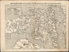
Das kunigreich Engellandt mit dem anstossenden Reich Schottlandt/ so vor zeiten Albion und Britannia han geheissen.
Earliest Accurate England.
- Digital Map Information
- Suitable for large format printing
- Full resolution TIFF file
- ICC color profile embedded
- Delivered instantly via download link
Earliest Accurate England.
This is Sebastian Münster's scarce woodcut map of England and Scotland and the northern parts of the European world, first added to his Geographia in 1540. It is the first detailed, modern printed map of England. 'This is a new map, substantially in advance of any others printed hitherto'. (Shirley). Although it was later included in his Cosmographia in 1544, it appeared in only 9 of the 34 editions, making it one of Münster's scarcest maps.A Closer Look
This east-oriented map presents England and Wales in their entirety; it includes part of Scotland, as far north as Edinburgh. At the right edge of the map, part of Brittany and Normandy appear, with Picardy in the upper right. Calais can be seen. Along the bottom edge, the east coast of Ireland appears. In the Irish Sea, the Isle of Man and Anglesey are shown and named. England is marked with a flag bearing its coat of arms (as adopted by Henry IV), and the Scottish arms appear on a flag in the lower left corner of the map. (Both coats of arms are shown in reverse, perhaps a formschneider's error.) Cities and Mountainous regions are indicated pictorially. The outline is detailed and reasonably accurate, including many river systems. These details, along with about eighty cities, appear here for the first time on a printed map.An Obscure Genealogy
Münster's books are notable for the disproportionate number of maps appearing within their pages that depict their respective regions for the first time to a broad audience; in some cases, his sources were manuscripts, and in other cases they were earlier printed works with a much smaller scope of publication. For this map, the specific source for Münster's map is unknown. Its orientation and overall outline have led to conjecture that it was modeled from a copy, or a derivative of the c. 1366 Gough, or Bodleian Map. However, many notable features of that notional precursor, such as Hadrian's wall, are absent here. Scholars generally agree that a variety of now-lost derivatives of the Gough existed, and that Münster had access to one of them. Peter Barber has proposed that one (also lost) map described in detail among the possessions of Christopher Columbus' son, Ferdinand, may well have been Münster's source.A Brief Appearance
This map was first included in Münster's 1540 Ptolemy, and appeared in all four confirmed editions of that work - 1540, 1542, 1545, and 1552. When Münster published his Cosmographia in 1544, the England map was among the complement of modern maps included. But when Münster expanded the book for its first Latin edition in 1550, he did so at the expense of the full-size foretext maps, replacing half of them with smaller, less detailed maps within the body of the text. This England map was among those to fall under the editor's knife. We can only speculate why such an excellent map should have been cut, but it was a deliberate step: Münster retained it in his 1552 Ptolemy. Thus, after appearing in only four editions of Cosmographia, the woodblock stayed in retirement for more than 20 years before being reintroduced in 1569. Its return may have been a cheap way to add material and revitalize a late edition of what had clearly been a staple for the publisher. Editions beginning in 1588 replaced the map with a completely new one based on Ortelius.Publication History and Census
This map first appeared in the 1540 edition of Münster's Geographia, appearing in all four editions. It was introduced to Cosmographia in 1544, but was not included in the 1550 editions nor any other until 1569. It remained in subsequent editions until 1578. The present example conforms typographically to the 1569 German text edition Cosmographia. The book is well represented in institutional collections. We see only one example of this issue of the separate map listed by the Universitätsbibliothek Eichstätt.Cartographer
Sebastian Münster (January 20, 1488 - May 26, 1552), was a German cartographer, cosmographer, Hebrew scholar and humanist. He was born at Ingelheim near Mainz, the son of Andreas Munster. He completed his studies at the Eberhard-Karls-Universität Tübingen in 1518, after which he was appointed to the University of Basel in 1527. As Professor of Hebrew, he edited the Hebrew Bible, accompanied by a Latin translation. In 1540 he published a Latin edition of Ptolemy's Geographia, which presented the ancient cartographer's 2nd century geographical data supplemented systematically with maps of the modern world. This was followed by what can be considered his principal work, the Cosmographia. First issued in 1544, this was the earliest German description of the modern world. It would become the go-to book for any literate layperson who wished to know about anywhere that was further than a day's journey from home. In preparation for his work on Cosmographia, Münster reached out to humanists around Europe and especially within the Holy Roman Empire, enlisting colleagues to provide him with up-to-date maps and views of their countries and cities, with the result that the book contains a disproportionate number of maps providing the first modern depictions of the areas they depict. Münster, as a religious man, was not producing a travel guide. Just as his work in ancient languages was intended to provide his students with as direct a connection as possible to scriptural revelation, his object in producing Cosmographia was to provide the reader with a description of all of creation: a further means of gaining revelation. The book, unsurprisingly, proved popular and was reissued in numerous editions and languages including Latin, French, Italian, and Czech. The last German edition was published in 1628, long after Münster's death of the plague in 1552. Cosmographia was one of the most successful and popular books of the 16th century, passing through 24 editions between 1544 and 1628. This success was due in part to its fascinating woodcuts (some by Hans Holbein the Younger, Urs Graf, Hans Rudolph Manuel Deutsch, and David Kandel). Münster's work was highly influential in reviving classical geography in 16th century Europe, and providing the intellectual foundations for the production of later compilations of cartographic work, such as Ortelius' Theatrum Orbis Terrarum Münster's output includes a small format 1536 map of Europe; the 1532 Grynaeus map of the world is also attributed to him. His non-geographical output includes Dictionarium trilingue in Latin, Greek, and Hebrew, and his 1537 Hebrew Gospel of Matthew. Most of Munster's work was published by his stepson, Heinrich Petri (Henricus Petrus), and his son Sebastian Henric Petri. Further Details...
Source
Münster, S., Cosmographey (Basel: Petri) 1569.
Following in the footsteps of Martin Waldseemuller and Lorent Fries before him, Sebastian Munster edited and published a modernized version of Claudius Ptolemy's Geographia. This appeared in six Latin editions in 1540, 1541, 1542, 1545, 1551 and 1552. According to Karrow, Munster based the text on the Latin translation of Willibald Pirkheimer, but he carefully collated it with previous editions, adding notes of his own. The first three editions contained 48 maps, consisting of 27 based on Ptolemy's ancient geography, and 21 maps based on modern geographical knowledge. The latter three editions contained 54 maps, comprised of the same ancient works but with six of the modern maps discarded, and twelve new ones added. For the collector, the modern maps are of sharpest interest. Some were based on Waldseemuller's geography, but many were based on Munster's own surveys and those of other European geographers whose assistance Munster had been able to enlist. Most of these would be reprised in Munster's magnum opus, Cosmographia Universalis. A disproportionate number of Munster's modern maps show contemporary geographical knowledge of the their respective areas for the very first time: The first map to show the continents of the Western Hemisphere; the first map to focus on the continent of Asia; the first modern map to name the Pacific Ocean. Even in cases where earlier maps exist, Munster's works very often remain the earliest such acquirable by the collector.
Condition
Very good. Marginal mends not impacting image, else excellent.
References
OCLC 634922790. Shirley, R. W., Early Printed Maps of the British Isles 1477-1650, #28. Barber, P., ed. Mark R. McDonald, Mark R., (The maps, town-views and historical prints in the Columbus inventory', in The Print Collection of Ferdinand Columbus 1488-1539, (London, British Museum)