This item has been sold, but you can get on the Waitlist to be notified if another example becomes available, or purchase a digital scan.
1710 Wit/ Mortier Map of England and Wales: a Scarce State
Angliae-wit-1710$250.00

Title
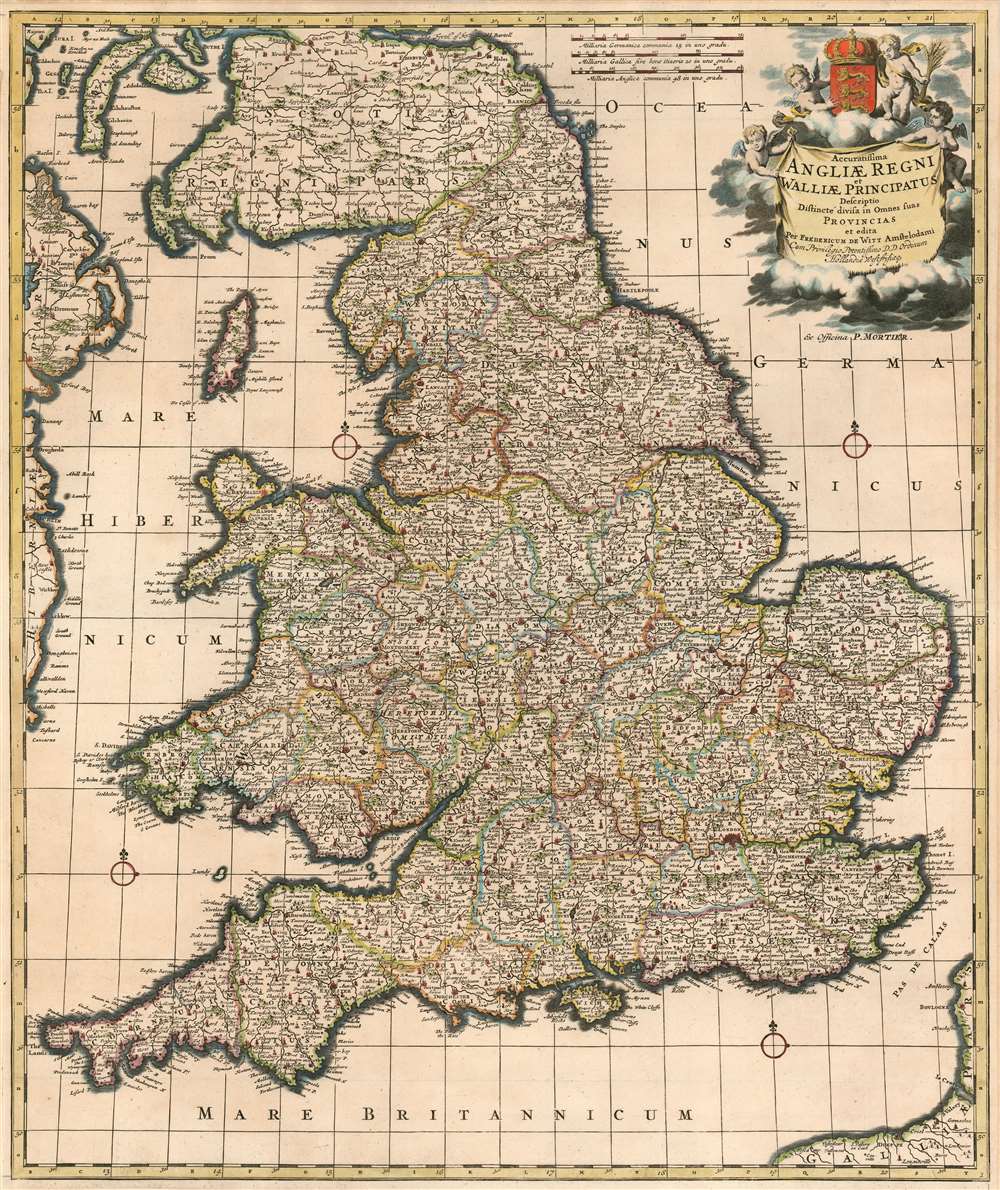
Accuratissima Angliae Regnum et Walliae Principatus Descriptio Distincté Divisa in Omnes Suas Provincias.
1710 (undated) 22.5 x 19 in (57.15 x 48.26 cm) 1 : 1300000
1710 (undated) 22.5 x 19 in (57.15 x 48.26 cm) 1 : 1300000
Description
This is Frederic De Wit's superbly engraved 1662 map of England and Wales, in one of its most complete states. De Wit's last, fifth state of the map (coinciding with his being granted his privilege, in 1689) exhibits the totality of its maker's aesthetic changes. De Wit completely re-engraved the cartouche and the scales at that time, with its four splendid putti and the crowned Royal Arms of England. The maps produced in Amsterdam in the latter part of the 17th century enjoyed both technological advances both in printing technology (resulting in larger presses, hence larger plates and larger maps) and in the art of engraving (resulting in finer and more dense geographical detail and toponymy.) Hence both as geographical documents and works of art, they represent great steps forward.
Publication History and Census
This map had a long printing life, appearing in De Wit's output as early as 1662. The map was frequently revised under De Wit's hand, with no fewer than five states of this map having been produced during his possession of the plate. After his widow's death in 1710 this, along with many of De Wit's other plates, were sold to Pierre Mortier who added his imprint and continued to sell the map otherwise unchanged. These appeared as separate issues, but were also included in Mortier's composite atlases from time to time. Despite occasional appearances on the market, examples with the P. Mortier imprint appear to be scarce, OCLC listing examples only at the Danish National Bibliotheque, Yale University, the Bayerische Staatsbibliothek, Landesbibliothek Coburg, and the National Library of Sweden.CartographerS
Frederik de Wit (1629 - 1706) was a Dutch Golden Age cartographer active in the second half of the 17th and the early 18th centuries. De Wit was born of middle class Protestant stock in the western Netherlandish town of Gouda. He relocated to Amsterdam sometime before 1648, where he worked under Willem Blaeu. His first attributed engraved map, a plan of Haarlem for Antonius Sanderus' Flandria Illustrata, was issued around this time. He struck out on his own in 1654. The first chart that De Wit personally both drew and engraved was most likely his 1659 map of Denmark, REGNI DANIÆ Accuratissima delineatio Perfeckte Kaerte van ‘t CONJNCKRYCK DENEMARCKEN. His great wall map of the world and most famous work, Nova Totius Terrarum Orbis Tabula appeared one year later. Following the publication of his wall map De Wit quickly rose in prominence as a both cartographer and engraver. He married Maria van der Way in 1661 and through her became a citizen of Amsterdam in 1662. Around this time he also published his first major atlas, a composite production ranging in size from 17 to over 150 maps and charts. Other atlases and individual maps followed. In 1689 De Wit was granted a 15 year Privilege by the Dutch States General. (An early copyright that protected the recipient's rights to print and publish.) He was recognized with the honorific 'Good Citizen' in 1694. De Wit died in 1706 after which his wife Maria continued publishing his maps until about 1710. De Wit's son, Franciscus, had no interest in the map trade, instead choosing to prosper as a stockfish merchant. On her own retirement, Maria sold most De Wit maps and plates at a public auction. Most were acquired by Pieter Mortier and laid the groundwork for the 1721 rise of Covens and Mortier, the largest Dutch cartographic publishing house of the 18th century. More by this mapmaker...
Pierre Mortier (January 26, 1661 - February 18, 1711) or Pieter Mortier was a cartographer, engraver, and print seller active in Amsterdam during the later 17th and early 18th centuries. Mortier, then known as Pieter, was born in Leiden. He relocated to Paris from 1681 to 1685, adopting the French name Pierre, which he retained throughout his career. While in France, he developed deep French connections by bringing sophisticated Dutch printing technology and experience to nascent French map publishers such as Guillaume De L'Isle (1675 - 1726), Alexis-Hubert Jaillot (c. 1632 - 1712), and Nicholas de Fer (1646 - 1720). Consequently, much of Mortier's business was built upon issuing embellished high quality editions of contemporary French maps - generally with the permissions of their original authors. In the greater context of global cartography, this was a significant advantage as most Dutch map publishes had, at this point, fallen into the miasma of reprinting their own outdated works. By contrast, the cartographers of France were producing the most accurate and up to date charts anywhere. Mortier's cartographic work culminated in the magnificent nautical atlas, Le Neptune Francois. He was awarded the Privilege, an early form of copyright, in 1690. Upon Pierre's death in 1711 this business was inherited by his widow. In 1721, his son Cornelius Mortier took over the day to day operation of the firm. Cornelius partnered with his brother-in-law Jean Covens to form one of history's great cartographic partnerships - Covens and Mortier - which continued to publish maps and atlases until about 1866. Learn More...
Source
Mortier, P. Atlas Maior Sive Collectio Mapparum Variis Autores
Condition
Good condition. Backed with archival tissue. Some reinstatement of margin not affecting printed image.
References
OCLC 16585398