This item has been sold, but you can get on the Waitlist to be notified if another example becomes available, or purchase a digital scan.
1893 Philip Map of Border Between British and Portuguese Central East Africa
AngloPortugueseBoundary-philip-1893$375.00

Title
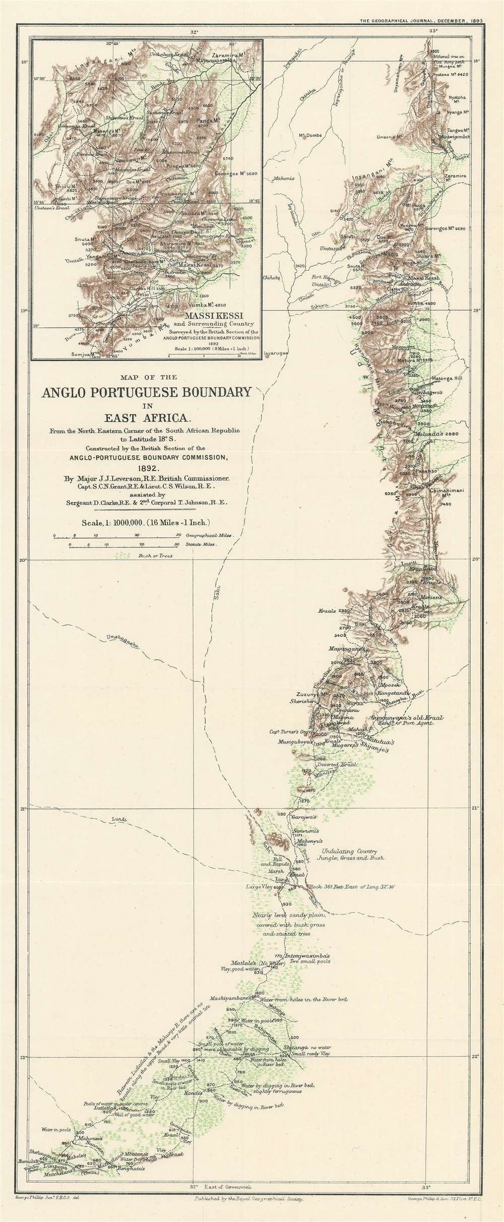
Map of the Anglo Portuguese Boundary in East Africa.
1893 (dated) 21.25 x 8.75 in (53.975 x 22.225 cm) 1 : 1000000
1893 (dated) 21.25 x 8.75 in (53.975 x 22.225 cm) 1 : 1000000
Description
This is an 1893 George Philip map of the border between British and Portuguese Central East Africa decided upon in the Anglo-Portuguese Treaty of 1891. Depicting the border as it was surveyed by the Anglo-Portuguese Delimination Commission in 1892, innumerable rivers, mountain peaks, and roads are identified. Green is used to highlight areas of trees and brush, while brown marks the spine of mountains that forms part of the newly designated border. Notes provide commentary on the terrain, water supply, vegetation, and animal life.
Anglo-Portuguese Treaty of 1891
The Anglo-Portuguese Treaty of 1891 ended over twenty years of conflict and disagreement between British and Portuguese territorial claims in eastern central Africa. It fixed the boundaries between the British Central Africa Protectorate, Mashonaland and Matabeleland (both administered by the British South Africa Company), North-Western Rhodesia, and Portuguese Mozambique, as well as the border between North-Eastern Rhodesia and Portuguese Angola. Conflicts began in the mid-19th century, when the Portuguese began to advocate for territorial claims connecting their African colonial possessions on the Atlantic and Indian Ocean coasts, respectively. This territory was ‘occupied’ at the time by British missionaries and business interests. Several treaties attempting to end the disagreement were never ratified, and the Berlin Conference of 1884-85, which created the concept of effective occupation instead of claims of discovery or exploration, effectively halted Portuguese claims. Nonetheless, the Portuguese continued to advocate for their ‘rights’ to this land and sent expeditions inland from both coasts to sign treaties with the local tribes. The British, ever cognizant of the presence of Church of England missionaries in the region, particularly in the Shire Highlands, never accepted any of the Portuguese proposals, and finally issued the 1890 British Ultimatum demanding the withdrawal of all Portuguese troops from Mashonaland, Matabeleland, and all the land between the Shire River north of the Ruo River and Lake Nyasa (Lake Malawi), which included the disputed Shire Highlands. Eventually, after two further failed attempts, the British and the Portuguese signed the 1891 treaty, which fixed all the borders between British and Portuguese territories in central East Africa.Publication History and Census
This map was created by George Philip and published by the Royal Geographical Society in the December 1893 edition of The Geographical Journal. One example is catalogued in the OCLC and it is part of the institutional collection at The British Library.CartographerS
George Philip (1800 - 1882) was a map publisher and cartographer active in the mid to late-19th century. Philip was born into a Calvinst family in Huntly, Aberdeenshire, Scotland. Around 1819 he apprenticed himself to William Grapel, a Liverpool printer and bookseller. Fifteen years later, in 1834, Philip founded his own Liverpool book and map firm. Philip's earliest cartographic ventures were mostly educational material issued in tandem with John Bartholomew Sr., August Petermann, and William Hughes. In 1848, Philip admitted his son, George Philip Jr. (1823 - 1902) into the firm, renaming it George Philip and Son Ltd. George Philip Jr. ran the firm until his death in 1902, by which time it had developed into a major publishing concern. His successors established the London Geographical Institute, a factory where they embraced modern printing techniques to produce thousands of economical and high quality maps. In April 1988, George Philip & Son was acquired by Octopus Publishing, a branch of Reed International. Nonetheless, today the firm trades and publishes to this day as George Philip and Son. More by this mapmaker...
Royal Geographical Society (fl. 1830 - present) is a British Society established in 1830 to promote geographical science and exploration. Originally titled the "Geographical Society of London", the RGS received its royal charter from Queen Victoria in 1859 shortly after absorbing several similar but more regional societies including the African Association, the Raleigh Club and the Palestine Association. The RGS sponsored many of the most important and exciting voyages of exploration ever undertaken, including the exploration of Charles Darwin, David Livingstone, Robert Falcon Scott, Richard F. Burton, John Speke, George Hayward, H. M Stanley, Ernest Shackleton and Sir Edmond Hillary. Today, the RGS remains a leading global sponsor of geographical and scientific studies. The Society is based in Lowther Lodge, South Kensington, London. Learn More...
Source
Leverson, J.J., 'Geographical Results of the Anglo-Portuguese Delimitation Commission in South-East Africa', The Geographical Journal. (London: Royal Geographical Society) December 1893.
Condition
Very good. Light wear and toning along original fold lines. Blank on verso.