This item has been sold, but you can get on the Waitlist to be notified if another example becomes available, or purchase a digital scan.
1894 Bartholomew Map of Antarctica and its Different Characteristics
AntarcticResearch-bartholomew-1894$175.00

Title
Antarctic Research. Series of Maps Illustrating Dr. John Murray's Address, 1893.
1894 (dated) 19 x 28 in (48.26 x 71.12 cm)
1894 (dated) 19 x 28 in (48.26 x 71.12 cm)
Description
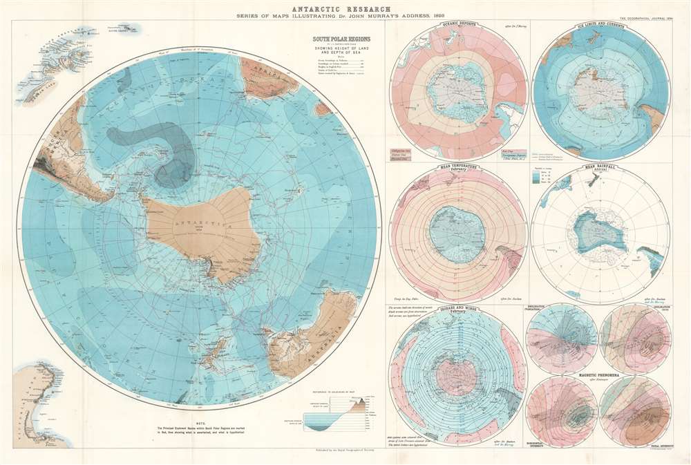
This is an 1894 John George Bartholomew map of Antarctica created to accompany Dr. John Murray's address to the Royal Geographical Society (RGS) in 1893. Consisting of one large map of the south polar regions and several smaller ones on one sheet, each map center's on Murray's proposed outline of Antarctica as he believed it existed following his experience as part of the Challenger Expedition. Over the course of his presentation to the RGS, Murray stated that, because of the presence of certain rocks dredged from the ocean floor in the south polar region, he was capable of scientifically confirming the long-hypothesized existence of an Antarctic continent. He even went so far as to state that he believed the continent to be larger than Australia! Each of the maps present on this sheet bears an illustration of Murray's proposed outline of Antarctica. A large portion of the data presented in these maps came directly from the archives of the Challenger Expedition, making a large portion of it new information to the public.
The Maps
The large map on the left side of the sheet centers on Antarctica and illustrates relative ocean depth and land elevation in the lower latitudes of the Southern Hemisphere. It notes the courses taken by several different explorers, including the Challenger Expedition and hypothesizes as to the extent of icepack out into the ocean from the continent itself. The rest of the maps illustrate various different aspects of the measurements taken during the expedition, illustrating oceanic deposits, mean ocean temperature in February, rainfall, magnetic phenomena, and ice limits and currents, and wind direction.Publication History and Census
This map was created by John George Bartholomew to accompany the text of Dr. John Murray's address and published in the Geographical Journal Vol. III No. I from January 1894. The OCLC catalogues examples of this map as being part of the institutional collections at Harvard University and the University of Chicago, and we are also aware of an example that is part of the collection at Princeton University. It is rare on the private market.CartographerS
Royal Geographical Society (fl. 1830 - present) is a British Society established in 1830 to promote geographical science and exploration. Originally titled the "Geographical Society of London", the RGS received its royal charter from Queen Victoria in 1859 shortly after absorbing several similar but more regional societies including the African Association, the Raleigh Club and the Palestine Association. The RGS sponsored many of the most important and exciting voyages of exploration ever undertaken, including the exploration of Charles Darwin, David Livingstone, Robert Falcon Scott, Richard F. Burton, John Speke, George Hayward, H. M Stanley, Ernest Shackleton and Sir Edmond Hillary. Today, the RGS remains a leading global sponsor of geographical and scientific studies. The Society is based in Lowther Lodge, South Kensington, London. More by this mapmaker...
The Bartholomew Family (fl. c. 1810 - 1920) is clan of map publishers active in London through the 19th century. They represent one of the great names in British cartography. The cartographic story of the Bartholomew family begins with George Bartholomew (January, 8 1784 - October 23, 1871, active from 1797), an engraver in the employ of the Daniel Lizars firm of Edinburgh. George was the first of six generations in the Bartholomew map-making dynasty. It was his son, John Bartholomew Sr. (1805 - April 9, 1861) who ultimately founded John Bartholomew and Sons in 1828. The John Bartholomew firm produced thousands of maps and rose to become one of the largest and most prolific cartography firms in Scotland. John Sr. was succeeded by his son, also John Bartholomew Jr. (1831-93). John George Bartholomew (1860-1920), son of John Bartholomew (1831-93) took control of the firm at its height. John George was a charter member of the Royal Scottish Geographical Society and supported the creation of a National Institute of Geography - a good idea that never took off. John George is also reliably attributed to be the first to bring the term "Antarctica" into popular usage as a denominator for the Southern Continent. In recognition of his work, John George was awarded a warrant from the king and often used the title "Cartographer to the King" on his imprint. Among his friends and admirers he was referred to as the "Prince of Cartography". John (Ian) Bartholomew (1890 - 1962) continued the family business and oversaw publication of the Times Survey Atlas of the World in 1922 and the Mid Century Edition of the Time Atlas of the World from 1955 - 1960. John Christoper Bartholomew (1923 - 2008) continued the family business into a fifth generation and was fascinated by the natural sciences. He spearheaded the publication of many of the most detailed and popular maps of the last century. His brother Robert, a trained printer, became production director. Another brother, Peter, an accountant, started as a managing director and eventually became executive chairman. The John Bartholomew firm has been part of the HarperCollins family of publishers since 1989. The vast archive of maps and atlases produced by the Bartholomew family has since been transferred to the National Library of Scotland where it is currently in the cataloguing process. Learn More...
John Murray (March 3, 1841 - March 16, 1914), considered the father of modern oceanography, was a British oceanographer, limnologist, and marine biologist. Born at Cobourg, Canada West, Murray attended school in London, Ontario, and later Cobourg College. He returned to Scotland in 1858 (his parents had emigrated from Scotland to Canada around 1834) to continue his education at Stirling High School and live with his grandfather. He enrolled at the University of Edinburgh in 1864 with the intention of studying medicine, but he did not finish his studies and did not graduate. Instead, he joined the crew of a whaling ship, the Jan Mayen, as the ship's surgeon and spent the seven-month voyage collecting marine specimens and recording data on ocean currents, ice movements, and the weather. He returned to Edinburgh later that year and reenrolled at the University to study geology, graduating in 1872. That same year, Murray joined the Challenger Expedition as a naturalist and spent the four-year voyage assisting in the research of the oceans. After the expedition's return, Murray was made a Chief Assistant at the Challenger offices and he managed and organized the expedition's collections. He became Director of the office in 1882 after the death of the expedition's chief scientist, Charles Wyville Thomson, and published The Report on the Scientific Results of the Voyage of HMS Challenger in 1896, which consisted of more than fifty volumes. Murray established the Marine Laboratory at Granton, Edinburgh, in 1884, the first laboratory of its kind in the United Kingdom. The lab was moved to Millport in 1894 and became the University Marine Biological Station, Millport, which is known today as the Scottish Association for Marine Science. Murray proposed an oceanographic expedition to the North Atlantic in 1909 and agreed to pay all the expenses. The Norwegian government, in turn, lent him the research ship Michael Sars and its scientific crew. The expedition was joined by Norwegian marine biologist Johan Hjort and set out in April 1910. It spent four months taking physical and biological observations at all depths between Europe and North America, and Murray and Hjort published The Depths of the Ocean with their findings in 1912, a book that became a classic for marine naturalists and oceanographers. Murray was killed on March 16, 1914, when his car overturned ten miles west of his home. Learn More...
Source
Murray, John, 'The Renewal of Antarctic Exploration', The Geographical Journal (London: Royal Geographical Society) 1894.
Condition
Very good. Light wear along original fold lines. Closed minor margin tear professionally repaired on verso. Blank on verso.
References
Princeton University Library G9801.C1 1893 .R6. OCLC 233035116. Clancy, R., J. Manning, and H. Brolsma, Mapping Antarctica: A Five Hundred Year Record of Discovery, (Springer Dordecht: Heidelberg New York London) 2014.