
This item below is out of stock, but another example (left) is available. To view the available item, click "Details."
Details
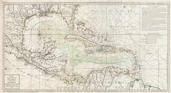
1780 Buache Map of the West Indies, Florida, and the Antilles
$2,500.00
1780 Buache Map of the West Indies, Florida, and the Antilles
AntillesMexiqueFlorida-buache-1780$1,500.00

Title
Carte du Golphe du Mexique et des isles Antilles.
1780 (dated) 20 x 37 in (50.8 x 93.98 cm)
1780 (dated) 20 x 37 in (50.8 x 93.98 cm)
Description
A fine example of the 1780 Dezauche edition of Buache's important map of the West Indies. Centered on Cuba, this massive map covers Central America, the Gulf of Mexico, the West Indies, and the Caribbean from Mexico and Texas to the Lesser Antilles and from Florida to the Spanish Main. Cartographically, Buache derived this map from Henry Popple's remarkable 1733 map of North America. As a whole it exhibits numerous significant advances over the earlier Buache / De L'Isle model of the region. These include a more sophisticated mapping of peninsular Florida, the Gulf Coast, and the interior of Texas, Florida, and Mexico. The Mission de Los Teijas, one of the first usages of the word 'Texas' on a published map, is noted. Rumb lines are evident throughout, suggesting this map was also based on sea chart sources.
The casual observer might note a similarity in form to Herman Moll's similarly sized 1710 map of the West Indies. Like Moll's map, Buache's map can be understood, though to a lesser extent, in the context of Caribbean piracy and privateering, which reached its zenith in the middle part of the 18th century. Buache identifies the trade winds with little arrows and the routes taken by Spanish Galleons traveling between the treasure ports of Havana and Veracruz. The Spanish treasure fleet entered the Caribbean via the passage between Granada and Trinidad. The fleet then sailed westwards, skirting the Spanish Main until they reached Cartagena, where they rested and provisioned before heading northwards, rounding western Cuba and stopping in Havana. Using the strong Gulf Stream current - shown here - ships would sail northwards from Havana while being steadily forced to the southeast thus alighting at the deep-water port of Veracruz. On the return, laden with silver from the mines of San Luis Potosi, the Spanish fleet took advantage of eastward blowing trade winds, which helped to overcome the strong current on the sail to Havana. From Havana they would travel northwards via the narrow passage between Florida and the Bahamas before cutting eastward and out to sea at St. Augustine. It was here, in this crucial passage between the English dominated Bahamas and Spanish Florida, that the most nefarious pirates lay in wait for their prey.
This map was published in J. Dezauche's 1780 reissue of G. De L'Isle and P. Buache's Atlas Geographique et Universel.
CartographerS
Phillipe Buache (February 7, 1700 - January 24, 1773) was a late 18th century French cartographer and map publisher. Buache began his cartographic career as the workshop assistant and apprentice to the important and prolific cartographer Guillaume de L'Isle. Upon De L'Isle's untimely death, Buache took over the publishing firm cementing the relationship by marrying De L'Isle's daughter. Over the years, Bauche republished many of De L'Isle's maps and charts. Buache was eventually appointed Premier Geographe du Roi, a position created-for and previously held by Guillaume de L'Isle. Buache is most respected for his introduction of hachuring as a method from displaying underwater elevation on a two dimensional map surface. Buache compiled maps based upon geographic knowledge, scholarly research, the journals of contemporary explorers and missionaries, and direct astronomical observation. Nevertheless, even in 18th century Paris geographical knowledge was severely limited - especially regarding those unexplored portions of the world, including the poles, the Pacific northwest of America, and the interior of Africa and South America. In these areas the Buache, like his primary rival Robert de Vaugondy, must be considered a speculative geographer or 'positive geographer'. Speculative geography was a genre of mapmaking that evolved in Europe, particularly Paris, in the middle to late 18th century. Cartographers in this genre would fill in unknown areas on their maps with speculations based upon their vast knowledge of cartography, personal geographical theories, and often dubious primary source material gathered by explorers and navigators. This approach, which attempted to use the known to validate the unknown, naturally engendered many rivalries. Buache's feuds with other cartographers, most specifically Didier Robert De Vaugondy, resulted in numerous conflicting papers being presented before the Academie des Sciences, of which both were members. The era of speculatively cartography effectively ended with the late 18th century explorations of Captain Cook, Jean Francois de Galaup de La Perouse, and George Vancouver. Buache was succeeded by his nephew Jean-Nicholas Buache de Neuville. More by this mapmaker...
Jean-Claude Dezauche (1745 - 1824) was a French map publisher active in Paris during the first half of the 19th century. He established his own engraving firm around 1770 after having engraved music since 1762. Dezauche bought the archives of Phillipe Buache and Guillaume de L'Isle from Jean Nicholas Buache, Buache's heir, in 1780. Dezauche soon obtained a monopoly on selling the charts produced by the Dépôt de la Marine. Jean-Claude Dezuache passed his business to his son, Jean André Dezauche, upon his death, who took over selling the Dépôt de la Marine charts. Learn More...
Source
Delisle, G., and Buache, P., Atlas Geographique et Universel, (Dezauche, Paris), 1789.
Condition
Very good condition. Original pressmark. Wide clean margins. Original color. Blank on verso. On two sheets joined by publisher.