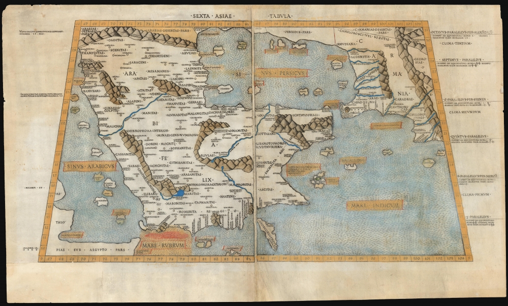
1478 / 1490 Ptolemaic Map of the Arabian Peninsula
Arabia-ptolemy-1478$65,000.00

Title
Sexta Asiae Tabula.
1478 (undated) 10.75 x 21 in (27.305 x 53.34 cm) 1 : 9600000
1478 (undated) 10.75 x 21 in (27.305 x 53.34 cm) 1 : 9600000
Description
A foundational work of Renaissance cartography: this is the first acquirable printed map of the Arabian Peninsula. Appearing in the Rome edition of Ptolemy, in its 1478 printing, it is preceded only by the unacquirable 1477 Bologna Ptolemy. Ptolemy's 2nd-century innovation of representing the three-dimensional world on a grided mathematical projection provided the basis of all modern cartography. Of all the early printed versions of Ptolemy's maps, those produced for the Rome edition are considered the finest until Mercator's 1578 edition. The present example is embellished with attractive old hand color.
The Engraver
This map, and all of those for the 1478 and 1490 editions of the Rome Ptolemy, was engraved by Konrad Sweynheim (or Schweinheim), a German printer who worked with Gutenberg in the early 1460s and who later set up the first press in Italy. Sweynheim's engravings were probably prepared prior to those of the 1477 Bologna Ptolemy and are, consequently, the earliest engraved copperplate maps. Moreover, the text of the printed maps was executed with the innovative use of movable type stamped directly into the copperplate, making the text both extremely uniform and legible. The work was far superior to prior manuscript editions, and indeed, according to SkeltonThe cleanness and precision with which geographical details are drawn; the skill with which the elements of the maps are arranged according to their significance, the sensitive use of the burin in working the plates - these qualities, in strong contrast to the careless design and crude cutting of the Bologna maps, seem to point to the hand of an experienced master.Beyond Sweynheim's superiority over contemporaneous engravers, the fine detail afforded by the copperplate process allowed the maps of the Rome Ptolemy to contain more legible detail than the manuscript and woodcut maps produced north of the Alps in the late 15th and early 16th-centuries. Nordenskiöld spotted the improvements:
They are based on the copies by Donis (Germanus) of Ptolemy's maps, but the style of the drawing is here greatly improved. Whilst, for instance, a very practical and convenient manner of indicating the mountains is used on these maps, Donis... only marked the mountain ranges by encircling lines. In uncoloured maps one was thus likely to confound mountains and seas, but this is no longer to be apprehended with the plain and handsome topographical dressing used in the maps of Schweinheim-Buckinck.
A Closer Look
Coverage extends from the Red Sea and the Horn of Africa to Persia, fully embracing the Arabian Peninsula and the Persian Gulf. Ptolemy's mapping of Arabia exhibits a distortion in the southeast part of the peninsula. Tibbets theorized that Ptolemy's information came from Arab tribesmen via the reports of Greek traders.Their journeys from place to place, measured by camel marches, must have been the basis for his calculations of the positions of inland towns… The errors of such a method are very great, for a town is placed at an uncertain distance and in a vague direction. Nothing is known of the meanderings of the route, circumventions of mountains, sands, or lava tracts, whilst the physical capacities of camels are not taken into account.Ptolemy's measurements of distance resulted in reasonable accuracy when contending with the Roman roads. However, his judgment of distances became less accurate further from the Mediterranean, so, unsurprisingly, the Arabian desert posed unique challenges. The toponymy reflects second-century Alexandrian scholarship: the explosion of Islam and the concurrent importance of Mecca, Medina, and other places occurred hundreds of years later, and thus, this is a pre-Islamic depiction of Arabia. Nevertheless, this map laid the foundations for the mapping the Arabian Peninsula in the 16th-century.
Watermarks and Dating the Rome Ptolemy
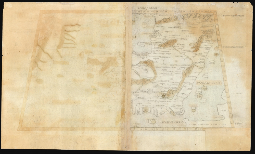
The watermarks in the paper on which these maps are printed are the only possible means for identifying specific editions, and even this has been an area of conflicting evidence. Peerlings, Laurentius, and Bovencamp, in their article The Watermarks in the Rome Editions of Ptolemy's Cosmography and More, make strides in resolving the issue. In their findings, the 1478 edition of the map is indicated by the presence solely of a specific 'crossbow' watermark. Later editions show an array of others: for example, the 1490 by a cardinal's hat, sometimes accompanied by sheets with a fleur de lis. A crown watermark can also be found in the 1490 edition. Several variations of a 'crossed-arrows' watermark are found starting in 1490, with a distinctive one appearing in 1507. The present example is watermarked with a fleur de lis, and so we assign the present example to the 1490 edition.Publication History and Census
This map was first engraved for publication in the 1478 Arnold Buckinck edition of Ptolemy's Geographia (which had, in the 15th century, become more widely known under the title Cosmography). Skelton estimated that the 1478 edition of the work was limited to 500 copies; subsequent editions are unlikely to have been much larger than 1000. Later editions were printed by Petrus de Turre in 1490 and by Bernardinus Venetus de Vitalibus in 1507 and 1508. The 1490 is listed in OCLC in 15 examples. We see no separate examples of the map so listed. It is scarce on the market.CartographerS
Claudius Ptolemy (83 - 161 AD) is considered to be the father of cartography. A native of Alexandria living at the height of the Roman Empire, Ptolemy was renowned as a student of Astronomy and Geography. His work as an astronomer, as published in his Almagest, held considerable influence over western thought until Isaac Newton. His cartographic influence remains to this day. Ptolemy was the first to introduce projection techniques and to publish an atlas, the Geographiae. Ptolemy based his geographical and historical information on the "Geographiae" of Strabo, the cartographic materials assembled by Marinus of Tyre, and contemporary accounts provided by the many traders and navigators passing through Alexandria. Ptolemy's Geographiae was a groundbreaking achievement far in advance of any known pre-existent cartography, not for any accuracy in its data, but in his method. His projection of a conic portion of the globe on a grid, and his meticulous tabulation of the known cities and geographical features of his world, allowed scholars for the first time to produce a mathematical model of the world's surface. In this, Ptolemy's work provided the foundation for all mapmaking to follow. His errors in the estimation of the size of the globe (more than twenty percent too small) resulted in Columbus's fateful expedition to India in 1492.
Ptolemy's text was lost to Western Europe in the middle ages, but survived in the Arab world and was passed along to the Greek world. Although the original text almost certainly did not include maps, the instructions contained in the text of Ptolemy's Geographiae allowed the execution of such maps. When vellum and paper books became available, manuscript examples of Ptolemy began to include maps. The earliest known manuscript Geographias survive from the fourteenth century; of Ptolemies that have come down to us today are based upon the manuscript editions produced in the mid 15th century by Donnus Nicolaus Germanus, who provided the basis for all but one of the printed fifteenth century editions of the work. More by this mapmaker...
Konrad Sweynheim (died 1477) was a German printer and engraver. Nothing is known of his early years. It is believed that he worked with Johannes Gutenberg between 1461 and 1464 and was instrumental in the early development of printing in Europe. He, along with Arnold Pannartz, is credited with having introduced Gutenberg's invention, the mechanical movable-type printing press, to Italy. The two printers first worked in Subiaco, printing a Donatus which has not survived. The earliest surviving book printed in Italy by them was Cicero's De oratore, printed in 1465. During the course of their early works, they abandoned the German typefaces they had worked with, becoming the first to print in Roman lettering. Sweynheim and Pannartz settled in Rome in 1467, working prolifically - but unsuccessfully: nobody wanted to buy their books, until they began receiving Church assistance in the early 1470s. At this point the two parted ways, after which Sweynheym took up copperplate engraving. He engraved the maps for the superb Rome Ptolemy but did not live to see the work through to its publication. This was completed by his fellow German printer Arnold Buckinck. The Rome Ptolemy was the second to be published containing maps engraved in copper, preceded only by the Bologne Ptolemy of 1477 (though it is probable that the copperplates were completed prior to those of the 1477.) An interesting idiosyncrasy of Sweynheim's work was that the text on the maps was not engraved by hand but stamped into the printing plate with specially made letters, the oldest known use of this technique for this purpose. Learn More...
Arnold Buckinck or Bucking (fl. 1478) was a German book printer in Rome. He is remembered only for the completion and publication of Konrad Sweynheim's edition of Claudius Ptolemy's Cosmographia, a work Buckinck completed on October 10, 1478. This edition was one of the first to contain maps engraved in copper. These plates were used by Petrus de Turre for his 1490 edition of Cosmographia and again by Bernardino Vitali in 1507 and 1508. Learn More...
Bernardino Vitali or Bernardinus de Vitalibus (fl. 1494 to 1539) was an Albanian printer and publisher, active in Venice but also operating presses in Rome and Rimini. In the first half of the 16th century, he published more than 200 Venetian humanist works. His early life is not understood, although he is thought to have been a refugee - settling in Venice after northern Albania fell to the Ottoman Empire. His Venice print shop opened in 1494, later opening shops in Rome and Rimini. Among his publications were the 1507 and 1508 editions of the Rome Ptolemy, which contained several new maps added to those from the 1478-90 editions: most notably, the famous Ruysch world map. Learn More...
Source
Ptolemy, C., In hoc opere haec continentur Geographiae Cl. Ptolemaei a plurimis uiris utriusq[ue] linguae doctiss. eme[n]data, et cu[m] archetypo Graeco ab ipsis collata, (Rome: Vitalibus) 1507-08.
Condition
Good. Printed to two sheets, joined for binding. Invisibly mended tear with no loss; margin reinstated to bottom left corner just touching border. Else very good, with color in an early hand.
References
OCLC 165589824 (1508). Tibbetts, G. R., Arabia in Early Maps, pp. 16-20, #4. Skelton, R. A., Introduction to the Facsimile edition of 1478 Rome Ptolemy, v-xiii. Suarez, T., Shedding the Veil, pp. 20-23.