This item has been sold, but you can get on the Waitlist to be notified if another example becomes available, or purchase a digital scan.
1574/ 1599 Ruscelli Edition of Gastaldi's Map of the Arabian Peninsula
Arabia-ruscelli-1574$375.00

Title
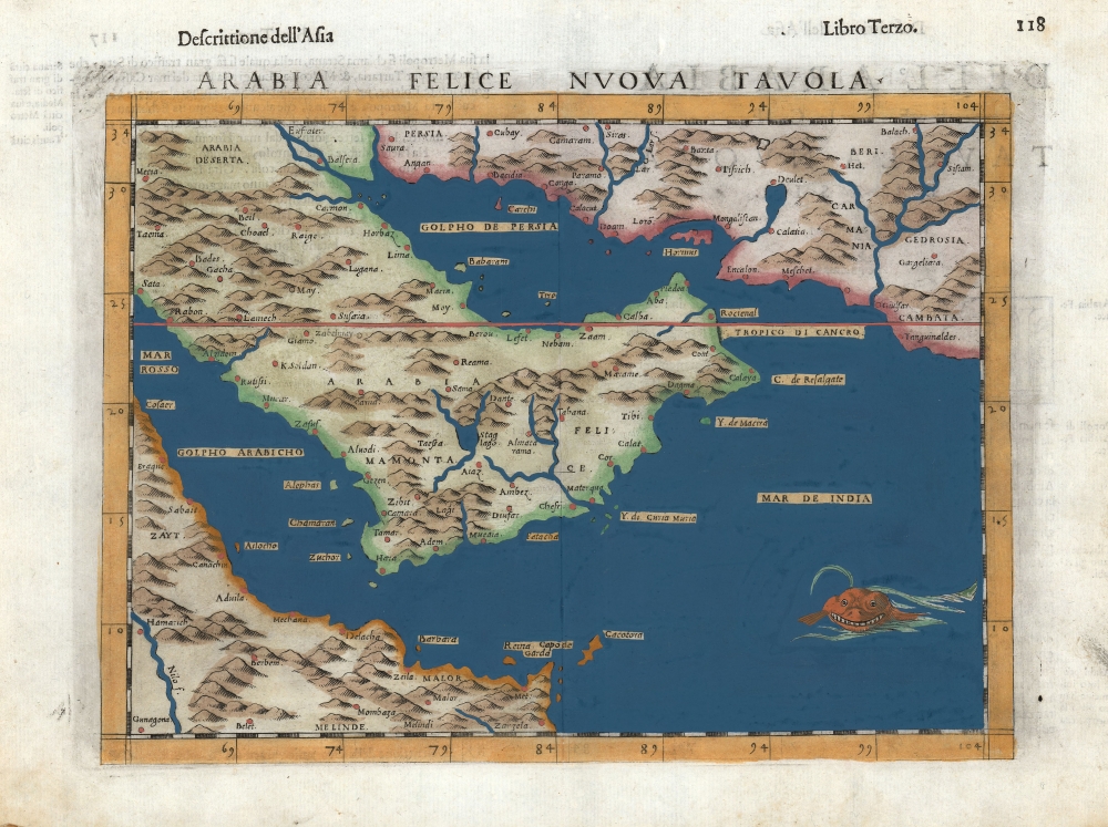
Arabia Felice Nuova Tavola.
1574 (undated) 7.5 x 9.5 in (19.05 x 24.13 cm) 1 : 19000000
1574 (undated) 7.5 x 9.5 in (19.05 x 24.13 cm) 1 : 19000000
Description
This is Girolamo Ruscelli's 1599 edition of Giocomo Gastaldi's modern map of the Arabian Peninsula, specifically the fertile part of Arabia, 'Arabia Felix.' After Gastaldi's 1548 work, it is nevertheless one of the earliest acquirable depictions of Arabia not based on the second century work of Claudius Ptolemy. The island of Bahrain (Babarem) appears. Also, this is one of the earliest works to depict a peninsula in the region of Qatar.
A Closer Look
While many of the topographical features are placed arbitrarily, there is a suggestion of the mountainous regions of Yemen, and the waterways and lakes placed there are suggestive of the fertility that led classical geographers to apply the term 'Felix' specifically to Yemen. That term would eventually be applied to the whole peninsula. This late edition of Ruscelli's map includes, in the Indian Ocean, a leering sea monster.Happy Felix
Printed maps, from the earliest, termed the Arabian Peninsula 'Arabia Felix' with 'Arabiae Petraeae' to the northwest (adjacent to the Holy Land) and 'Arabiae Desertae' to the northeast (adjacent to the Fertile Crescent.) The Greek scholar Eratosthenes of Cyrene had termed the southernmost parts of Arabia - Yemen specifically - as Arabia Eudaimon, and it was this term that the Romans translated to Arabia Felix. These words had simultaneous meanings - primarily as 'fecund, fertile' and only secondarily as 'happy.' Maps derived from Ptolemy, up into the 16th century, would continue to apply the term 'Felix' in contrast to the 'stony' or 'desert' Arabias. Gastaldi's 1548 map translated that from Latin to the Italian 'Felixe' - a natural transition, except that in Italian the word's primary meaning skewed more primarily to 'happy, content.' (Ruscelli's spelling of 'Felice' in the title of this map is also consistent with that meaning.) As early as 1552 French translations of Münster's Cosmographia used the term 'Heureuse Arabie'. 'Heureuse' contains the 'happy' connotations. Classical authors associated 'Arabia Felix' with Yemen specifically, as with the present work - thus emphasizing a long association of Yemen as a fruitful land, stretching as far back as the Roman Era. Much of this reputation was tied to a near-monopoly in the trade of cinnamon and spice from both India and the Horn of Africa, particularly via the port of Aden. Yemen itself was a major source of frankincense well before Ptolemy's time. By the 16th century, Yemen began to export drinking coffee, and indeed was the world's sole exporter of coffee until the 18th century.Publication History and Census
This map was engraved for inclusion in the 1561 edition of Girolamo Ruscelli's Ptolemy. The maps for the 1561, 1562 and 1564 printings were printed two-to-a-plate, and examples of such maps exhibit platemarks running off the top of the page. This specific map was entirely reengraved to a new plate for the 1574 edition of the book. Among its many differences, the spelling of 'Mombasa' in Africa is an indication of this change (the 1561 spells it 'Mombesa.') In addition, prior to the 1598 - 1599 edition of the work, the sea monster was added to the Indian Ocean. These editions are also characterized by the letterpress text across the top, as here. Our example is of the second plate, and it conforms typographically to the 1599 edition. Ruscelli's Ptolemy is well represented in institutional collections in its various editions, and the separate map appears on the market.CartographerS
Giacomo Gastaldi (c. 1500 - October, 1566) was an Italian astronomer, cartographer, and engineer active in the second half of the 16th century. Gastaldi (sometimes referred to as Jacopo or Iacobo) began his career as an engineer, serving the Venetian Republic in that capacity until the fourth decade of the sixteenth century. During this time he traveled extensively, building a large library relating to voyages and exploration. From about 1544 he turned his attention to mapmaking, working extensively with Gextantiovanni Battista Ramusio, Nicolo Bascarini, and Giovanbattista Pedrezano, as well as taking private commissions for, among others, Venice's Council of Ten. He is credited with the fresco maps of Asia and Africa still extant in the map room of the Doge's Palace. Gastaldi was also one of the first cartographers to embrace copper plate over woodblock engraving, marking an important development in the history of cartography. His 1548 edition of Ptolemy's Geographia was the first to be printed in a vernacular; it was the first to be printed in copperplate. As with his Swiss/German contemporary Münster, Gastaldi's work contained many maps depicting newly discovered regions for the first time, including the first map to focus on the East Coast of North America, and the first modern map of the Indian Peninsula. His works provided the source for the vast majority of the Venetian and Roman map publishers of the 1560s and 70s, and would continue to provide an outsize influence on the early maps of Ortelius, De Jode, and Mercator. More by this mapmaker...
Girolamo Ruscelli (1500 - 1566) was an Italian polymath, humanist, editor, and cartographer active in Venice during the early 16th century. Born in Viterbo, Ruscelli lived in Aquileia, Padua, Rome and Naples before relocating to Venice, where he spent much of his life. Cartographically, Ruscelli is best known for his important revision of Ptolemy's Geographia, which was published posthumously in 1574. Ruscelli, basing his work on Gastaldi's 1548 expansion of Ptolemy, added some 37 new "Ptolemaic" maps to his Italian translation of the Geographia. Ruscelli is also listed as the editor to such important works as Boccaccio's Decameron, Petrarch's verse, Ariosto's Orlando Furioso, and various other works. In addition to his well-known cartographic work many scholars associate Ruscelli with Alexius Pedemontanus, author of the popular De' Secreti del R. D. Alessio Piemontese. This well-known work, or "Book of Secrets" was a compilation of scientific and quasi-scientific medical recipes, household advice, and technical commentary on a range of topics that included metallurgy, alchemy, dyeing, perfume making. Ruscelli, as Alexius, founded a "Academy of Secrets," a group of noblemen and humanists dedicated to unearthing "forbidden" scientific knowledge. This was the first known experimental scientific society and was later imitated by a number of other groups throughout Europe, including the Accademia dei Secreti of Naples. Learn More...
Source
Ruscelli, G., La Geografia di Claudio Tolomeo Alessandrino…, (Venice: Heredi di Melchoir Sessa) 1599.
Beginning in 1561, Girolamo Ruscelli published this important, expanded edition of Giacomo Gastaldi's 1548 Ptolemy. Its maps, engraved in Venice by Giulio Sanuto, were in the main based directly upon those in Gastaldi's 1548 work. The maps were larger format than Gastaldi's, however, and Sanuto's engraving was far clearer and more legible than those appearing in the 1548 work. There are some important additions that distinguish Ruscell's Ptolemy from Gastaldi's. Ruscelli's work contained a map of the habitable world according to Ptolemy, which the Gastaldi lacked; also, the double-hemisphere map appearing in the Ruscelli was new and did not appear in the Gastaldi. Ruscelli's modern map of England was based on the work of George Lily, rather than the Waldseemüller-derived map appearing in the Gastaldi; the Ruscelli is the earliest generally acquirable map of England based on knowledge from someone who lived there. In a fateful innovation, Ruscelli's work included Septentrionalium partium nova tabula,the first copy of Nicolo Zeno's 1558 fraud Carta da Navegar, which introduced a novel mapping of the north parts of the world, including the phantom islands of Frisland, Icaria, Drogeo and Estotiland. Had Ruscelli not copied the Zeno - which had a narrow, brief publication - this preposterous geography would have probably not taken hold. Its inclusion in Ruscelli's beautiful, authoritative and popular work would lead to the adoption of the Zeno map by Mercator, Ortelius, Plancius and their successors, baffling scholars for centuries. Ruscelli's Ptolemy had a long publication history, cementing the influence of the work. It appeared both in Italian and Latin editions, all printed in Venice, throughout the latter 16th century:
- 1561 La Geographia di Claudio Tolomeo Alessandrino, Italian. Venice, Vincenzo Valgrisi.
- 1562 Geographia Cl. Ptolemaei Alexandrini, Latin. Venice, Vincenzo Valgrisi.
- 1564 La Geographia di Claudio Tolomeo Alessandrino, Italian. Venice, Giordano Ziletti.
- 1564 Geographia Cl. Ptolemaei Alexandrini, Latin. Venice, Giordano Ziletti.
- 1574 La Geographia di Claudio Tolomeo Alessandrino, Italian. Venice, Giordano Ziletti.
- 1598 Geographia di Claudio Tolomeo Alessandrino, Italian. Venice, heirs of Melchoir Sessa.
- 1599 Geographia di Claudio Tolomeo Alessandrino, Italian. Venice, heirs of Melchoir Sessa.
Condition
Very good. Worn corners, some soiling to margins.
References
OCLC 500417752. (1574) Rumsey 11299.063. Al Ankary, Khaled The Arabian Peninsula in Old European Maps plate 12.