This item has been sold, but you can get on the Waitlist to be notified if another example becomes available, or purchase a digital scan.
1654 Nicolas Sanson Map of Arabia
Arabia-sanson-1654$900.00
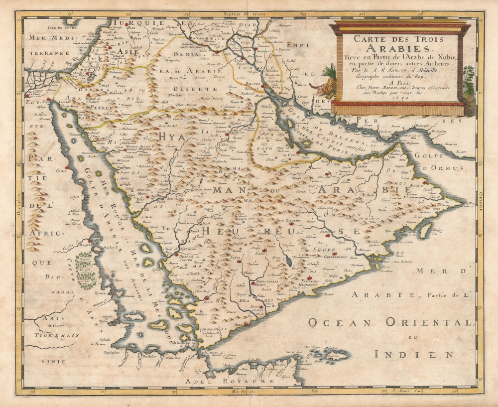

Title
Carte des Trois Arabies Tirée en Parte de l'Arabe de Nubie, en partie de divers autres Autheurs, Par le S. N. Sanson d'Abbeville, Geographe ordinaire du Roy, A Paris.
1654 (dated) 15.5 x 19 in (39.37 x 48.26 cm) 1 : 7500000
1654 (dated) 15.5 x 19 in (39.37 x 48.26 cm) 1 : 7500000
Description
This is an attractive example of Nicolas Sanson's scarce 1654 map of the Arabian Peninsula. As indicated in the title, it depicts the three Arabias: Arabie Petree, Arabie Deserte, and Arabia Heureuse; that is, Stony Arabia, Desert Arabia, and 'Happy' Arabia. The map depicts both shores of the Red Sea and the Persian Gulf, and the Indian Ocean island of Zocotora off the horn of Africa. The map includes Mecca and Medina, and the pattern of named settlements describes the Hajj routes: along the Red Sea coast, the overland routes across the peninsula from Basra, and the route to Mecca from Damascus. The Kingdom of Bahrain (Bahraim) appears as well. The largest portion of the Arabian Peninsula is here named Hyaman, ou Arabie Heureuse: 'Yemen, or Happy Arabia.'
Happy Arabia?
Printed maps, from the earliest, termed the Arabian Peninsula 'Arabia Felix' with 'Arabiae Petraeae' to the northwest (adjacent to the Holy Land) and 'Arabiae Desertae' to the northeast (adjacent to the Fertile Crescent.) The Greek scholar Eratosthenes of Cyrene had termed the southernmost parts of Arabia - Yemen specifically - as Arabia Eudaimon, and it was this term that the Romans translated to Arabia Felix. These words had simultaneous meanings - primarily as 'fecund, fertile' and only secondarily as 'happy.' Maps derived from Ptolemy, up into the 16th century, would continue to apply the term 'Felix' in contrast to the 'stony' or 'desert' Arabias. Gastaldi's 1548 map would translate that from the Latin to the Italian 'Felixe' - a natural transition, except that in Italian the word's primary meaning skewed more primarily to 'happy, content.' As early as 1552 we see French translations of Münster's Cosmographia using the term 'Heureuse Arabie;' 'Heureuse' contains the 'happy' connotations, but not those of fertility. In 1575 the French cartographer Thevet would apply that word in his map of Asia. By the time John Speed produced his 1626 map of the Turkish Empire, his Arabian Peninsula would be named 'Happie Arabia.' The modern maps, in addition, tend to associate 'Arabia Felix' with Yemen, as with the present work - thus emphasizing a long association of Yemen as a fruitful land, stretching as far back as the Roman era. Much of this reputation was tied to a near-monopoly in the trade of cinnamon and spice from both India and the Horn of Africa, particularly via the port of Aden. Yemen itself was a major source of frankincense well before Ptolemy's time. By the 16th century, Yemen had begun to export drinking coffee, and indeed would be the world's sole exporter of coffee until the 18th century.The Source
Sanson's work appears to be the earliest printed map to include detail reflective of actual travelers' reports from the Islamic era, particularly with respect to the pilgrimages to Mecca and Medina from other parts of the Muslim world. While this knowledge does not extend (for example) to Arabia's mountain ranges, there is evidence in actual report of the Hajj in the naming and placement of settlements sequentially linking Damascus to Medina and Mecca, as well as linking Mecca with the cities of the Tigris and Euphrates river basin. These details appear to derive from the work - cited in the cartouche - of 'The Arab of Nubia,' an appellation of the 12th century Moroccan Arab geographer and scholar Muhammad al-Idrisi. During an eighteen-year tenure in the court of King Roger II of Sicily, al-Idrisi produced a detailed geography (with an accompanying map) of the Arab world whose scope far outstripped anything known to western Europe until the late Renaissance. Despite its abundant detail, al-Idrisi's Kitab nuzhat al-mushtaq (roughly 'A Diversion for the Man Longing to Travel to Far-Off Places') would languish in obscurity until its abridged translation to Latin in 1619. Even then, it appears to not have impacted European maps until the middle of the seventeenth century, specifically in the content of the present map. Until its publication we see no evidence of sharp detail from Islamic sources; later in the seventeenth century we see maps by De Wit and Danckerts containing the details first revealed on Sanson's map.Manuscript Verso Text
This example has French verso text - not printed, but manuscript, in several hands. The first writer describes the Island of Zocotora (whose wealth is described as consisting principally of aloes and civet) and Arabia, (said to produce myrrh, balsam, cassia, cinnamon, in general all sorts of spices, and odoriferous trees, and frankincense in large quantities). A second writer describes the Red Sea, Suez, the kingdom of Hormuz, and addresses both Mecca and Medina with respect to the Hajj and their relevance to Islam. A third hand again describes Zocotora, but this time details of its (few) cows and sheep, and its production of dates and oranges.Publication History and Census
This map was engraved by Jan Somer for inclusion in Sanson's atlases, published in partnership with Pierre Mariette. Twenty-four examples are listed in institutional collections, but this map is scarce on the market.CartographerS
Nicolas Sanson (December 20, 1600 - July 7, 1667) and his descendants were the most influential French cartographers of the 17th century and laid the groundwork for the Golden Age of French Cartography. Sanson was born in Picardy, but his family was of Scottish Descent. He studied with the Jesuit Fathers at Amiens. Sanson started his career as a historian where, it is said, he turned to cartography as a way to illustrate his historical studies. In the course of his research some of his fine maps came to the attention of King Louis XIII who, admiring the quality of his work, appointed Sanson Geographe Ordinaire du Roi. Sanson's duties in this coveted position included advising the king on matters of geography and compiling the royal cartographic archive. In 1644, he partnered with Pierre Mariette, an established print dealer and engraver, whose business savvy and ready capital enabled Sanson to publish an enormous quantity of maps. Sanson's corpus of some three hundred maps initiated the golden age of French mapmaking and he is considered the 'Father of French Cartography.' His work is distinguished as being the first of the 'Positivist Cartographers,' a primarily French school of cartography that valued scientific observation over historical cartographic conventions. The practice result of the is less embellishment of geographical imagery, as was common in the Dutch Golden Age maps of the 16th century, in favor of conventionalized cartographic representational modes. Sanson is most admired for his construction of the magnificent atlas Cartes Generales de Toutes les Parties du Monde. Sanson's maps of North America, Amerique Septentrionale (1650), Le Nouveau Mexique et La Floride (1656), and La Canada ou Nouvelle France (1656) are exceptionally notable for their important contributions to the cartographic perceptions of the New World. Both maps utilize the discoveries of important French missionaries and are among the first published maps to show the Great Lakes in recognizable form. Sanson was also an active proponent of the insular California theory, wherein it was speculated that California was an island rather than a peninsula. After his death, Sanson's maps were frequently republished, without updates, by his sons, Guillaume (1633 - 1703) and Adrien Sanson (1639 - 1718). Even so, Sanson's true cartographic legacy as a 'positivist geographer' was carried on by others, including Alexis-Hubert Jaillot, Guillaume De L'Isle, Gilles Robert de Vaugondy, and Pierre Duval. More by this mapmaker...
Pierre Mariette (1569 - 1657) was a French publisher and engraver active in Paris during the first half of the 19th century. Mariette established himself as successful publisher of art prints, but decided to turn his energy to cartography with the purchase of the plates for Melchior Tavernier's maps in 1644. Tavernier had partnered with Sanson before his death and Mariette followed suit. Around 1644- 1648 Mariette partnered with Nicolas Sanson, a then nascent figure in French cartography, to produce folio maps and atlases. The Sanson-Mariette relationship depended upon Sanson to draw and obtain rights for the maps while Mariette engraved them and paid for the expensive printing process. The two then shared rights to the maps into perpetuity. The finished copper plates were split between two such that neither could publish an atlas without the other's assent. The relationship seemed reasonably amicable until Mariette's death in 1657, when disputes arose between Sanson and Mariette's heirs. A court battle finally returned the most of the plates to Sanson's own heirs in 1674. As a consequence, some printings feature the Mariette imprint, others the Sanson imprint, and still others both imprints. Learn More...
Abu Abdullah Muhammad al-Idrisi al-Qurtubi al-Hasani as-Sabti (1100 - 1165) was a Moroccan-Arab Geographer, writer, scientist and cartographer. He lived 18 years in Palermo, Sicily as part of the court of King Roger II, for whom he produced a detailed description of the Muslim world at that time, and drew one of the most advanced world maps of the medieval era (the Tabula Rogeriana.) al-Idrisi was born in Ceuta (now part of Spain) to the large and illustrious Hammudid family (which claimed descent from the Prophet Muhammad.) He is thought to have studied in Córdoba; He traveled broadly, mainly in North Africa and Muslim Spain, but is thought to have reached as far as York in England. Political instability led al-Idrisi and other scholars to seek asylum with the Norman kingdom of Sicily, and it was there that he produced his most famous geographical work: the 1154 manuscript Tabula Rogeriana, and his geography, Kitab nuzhat al-mushtaq fi'khtiraq al-'afaq, or 'A Diversion for the Man Longing to Travel to Far-Off Places'.' His work was astonishing in its scope: it included descriptions of Iceland and Greenland, as well as details of the goods likely to be found upon Chinese trade vessels, and the quality of the silk of Quanzhou. But while his work - which survives in nine manuscripts - influenced Islamic scholars, it was ignored in western Europe until well into the sixteenth century. The abridged Arabic text was finally printed in Rome in 1592, one of the first Arabic books ever printed. The first translation from the original Arabic into Latin was published in Paris in 1619 as Geographia nubiensis (The Geography of the Nubian). Learn More...
Source
Sanson, N. and G., Cartes et Tables de la Geographie Ancienne et Nouvelle, (Paris: Mariette) 1657.
Condition
Very good. Light toning and foxing. Some creasing at centerfold. Else excellent with attractive, old, possibly contemporary hand color.
References
OCLC 60634896. Rumsey 9741.119. Tibbetts, G. R., Arabia in Early Maps, #98, plate 10.