This item has been sold, but you can get on the Waitlist to be notified if another example becomes available, or purchase a digital scan.
1513 Waldseemuller Map of Arabia
Arabia-waldseemuller-1513$5,000.00

Title
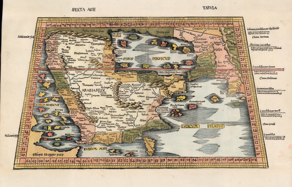
Sexta Asie Tabula.
1513 (undated) 12.5 x 21.75 in (31.75 x 55.245 cm) 1 : 9300000
1513 (undated) 12.5 x 21.75 in (31.75 x 55.245 cm) 1 : 9300000
Description
This is the Waldseemüller / Ringmann 1513 map of Arabia, considered one of the earliest acquirable maps of the Arabian Peninsula and essential to any serious Arabia collection. It was issued for Waldseemüller and Ringmann's 1513 Geographie Opus Novissima, then the most thoroughly edited and amended edition of Ptolemy. Moreover, this map was the most detailed map of the Arabian Peninsula to have been produced to date, illustrating and naming many of the islands of the Red Sea and the Persian Gulf, and including comprehensive interior detail. Despite presenting ancient geography, the detail of Ptolemaic maps of the region had yet to be improved upon significantly, and so this map remained one of the most detailed maps of the Arabian Peninsula available, illustrating and naming many of the islands of the Red Sea and the Persian Gulf, and including comprehensive interior detail.
The Scope of the Map
Coverage extends from the Red Sea and the Horn of Africa to Persia, fully embracing the Arabian Peninsula and the Persian Gulf. Here, the outline of Arabia is recognizable, even if the surrounding islands are exaggerated. The toponymy reflects second-century Alexandrian scholarship: the explosion of Islam, and the concurrent importance of Mecca, Medina, and other places, occurred hundreds of years later. Nevertheless, Ptolemy's knowledge of Arabia was better than many other regions on the Roman periphery. Rome had engaged in efforts to dominate the peninsula in the first century CE, with the object of controlling the trade center in southern Arabia, a key link to India. Rome established bases around Arabia and made forays from the north, via the Hejaz, and via the Red Sea. These ventures reached as far as Najran and parts of Yemen. Between these reports and those dating to Alexander the Great, Ptolemy had a wealth of place names to catalog for this region. Tibbets theorized that much of Ptolemy's information also came from Arab tribesmen via the reports of Greek traders.Their journeys from place to place, measured by camel marches, must have been the basis for his calculations of the positions of inland towns… The errors of such a method are very great, for a town is placed at an uncertain distance and in a vague direction. Nothing is known of the meanderings of the route, circumventions of mountains, sands, or lava tracts, whilst the physical capacities of camels are not taken into account.Ptolemy's measurements of distance resulted in reasonable accuracy when contending with the Roman roads. However, his judgment of distances became less accurate further from the Mediterranean, so, unsurprisingly, the Arabian desert posed unique challenges. The toponymy reflects second-century Alexandrian scholarship: the explosion of Islam and the concurrent importance of Mecca, Medina, and other places occurred hundreds of years later, and thus, this is a pre-Islamic depiction of Arabia. Nevertheless, when Ptolemy's work began to appear in its fifteenth century and early sixteenth century printed editions, this map represented the foundation for the mapping the Arabian Peninsula. Printed maps exhibiting modern depictions of Arabia began to appear as early as 1513, but their detail would not rival the Ptolemaic maps until Gastaldi's 1548 map.
A New Ptolemy
This map appeared in the 1513 edition of Claudius Ptolemy's Geographia, whose translation and maps were the collaboration of Martin Waldseemüller and Matthias Ringmann, best known for their 1507 world map, Universalis Cosmographia. Starting with the maps printed in the 1482 Ulm Ptolemy, Waldseemüller and Ringmann consulted a variety of Greek and Latin sources in order to produce an authoritative, corrected edition of the classical proto-atlas. In addition to the twenty-seven maps based strictly on Ptolemy's data, it included twenty Tabulae Modernae. Among these maps are the first printed maps to focus on regions unknown to Ptolemy such as North America and southern Africa, but they also include maps of areas covered in Ptolemaic geography but with new topography and toponymy based on contemporaneous information, such as the maps of Lorraine and the upper Rhine (which Waldseemüller probably surveyed himself) and a map of Crete. Ironically, Waldseemüller's name did not appear in the published book, as he and Ringmann had had a falling out by 1513.Publication History and Census
This map was drawn between 1507 and 1513 by Martin Waldseemüller at the Gymnasium Vosagense, an association of humanist scholars formed in Saint-Dié under the patronage of the Duke of Lorraine. The map was included in the Gymnasium's Geographie Opus Novissima Traductione e Graecorum Archetypis, printed in 1513 by Johannes Schott (Strasbourg). Schott published a single further edition of the book in 1520; there were no alterations to the maps, but patterns of wear and cracking to the block suggest a dating of 1520 for this example. We find two examples of this separate map listed in OCLC, one dated 1513 and one dated 1520, both in the Universitatsbibliothek Eichstatt. Rare to the private market.CartographerS
Martin Waldseemüller (September 11, 1470 - March 16, 1520) was a German cartographer, astronomer, and mathematician credited with creating, along with Matthias Ringmann, the first map to use the placename America. He was born in Wolfenweiler, near Freiburg im Breisgau. Waldseemüller studied at the University of Freiburg and, on April 25, 1507, became a member of the Gymnasium Vosagese at Saint-Dié. Martin Waldseemüller was a major proponent of theoretical or additive cartography. Unlike contemporary Portuguese and Spanish cartographers, who left maps blank where knowledge was lacking, Waldseemüller and his peers speculated based upon geographical theories to fill unknown parts of the map. He is best known for his Universalis Cosmographia a massive 12-part wall map of the world considered the first map to contain the name America, today dubbed as 'America's Birth Certificate'. This map also had significance on other levels, as it combined two previously unassociated geographical styles: Ptolemaic Cartography, based on an ancient Greek model, and the emergent 'carta marina', a type of map commonly used by European mariners in the late 15th and 16th centuries. It also extended the traditional Ptolemaic model westward to include the newly discovered continent of America, which Waldseemüller named after the person he considered most influential in its discovery, Amerigo Vespucci. When Waldseemüller died in 1520, he was a canon of the collegiate Church of Saint-Dié. In contemporary references his name is often Latinized as Martinus Ilacomylus, Ilacomilus, or Hylacomylus. More by this mapmaker...
Claudius Ptolemy (83 - 161 AD) is considered to be the father of cartography. A native of Alexandria living at the height of the Roman Empire, Ptolemy was renowned as a student of Astronomy and Geography. His work as an astronomer, as published in his Almagest, held considerable influence over western thought until Isaac Newton. His cartographic influence remains to this day. Ptolemy was the first to introduce projection techniques and to publish an atlas, the Geographiae. Ptolemy based his geographical and historical information on the "Geographiae" of Strabo, the cartographic materials assembled by Marinus of Tyre, and contemporary accounts provided by the many traders and navigators passing through Alexandria. Ptolemy's Geographiae was a groundbreaking achievement far in advance of any known pre-existent cartography, not for any accuracy in its data, but in his method. His projection of a conic portion of the globe on a grid, and his meticulous tabulation of the known cities and geographical features of his world, allowed scholars for the first time to produce a mathematical model of the world's surface. In this, Ptolemy's work provided the foundation for all mapmaking to follow. His errors in the estimation of the size of the globe (more than twenty percent too small) resulted in Columbus's fateful expedition to India in 1492.
Ptolemy's text was lost to Western Europe in the middle ages, but survived in the Arab world and was passed along to the Greek world. Although the original text almost certainly did not include maps, the instructions contained in the text of Ptolemy's Geographiae allowed the execution of such maps. When vellum and paper books became available, manuscript examples of Ptolemy began to include maps. The earliest known manuscript Geographias survive from the fourteenth century; of Ptolemies that have come down to us today are based upon the manuscript editions produced in the mid 15th century by Donnus Nicolaus Germanus, who provided the basis for all but one of the printed fifteenth century editions of the work. Learn More...
Source
Waldseemüller, M. / Ringmann, M., Geographie Opus Novissima Traductione E Graecorum Archetypis, (Strasbourg: Schott) 1513.
Condition
Very good. Remargined at top and bottom with no loss to map area. Title in upper margin reinstated in facsimile. The color is properly reactive to blacklight, suggesting some age, but it was likely refreshed when remargined.
References
OCLC 633217886. Tibbetts, G. R. Arabia in Early Maps #13.