This item has been sold, but you can get on the Waitlist to be notified if another example becomes available, or purchase a digital scan.
1730 De L'Isle Map of Arabia, Egypt, and Abyssinia
ArabiaEgypt-covensmortier-1730$375.00

Title
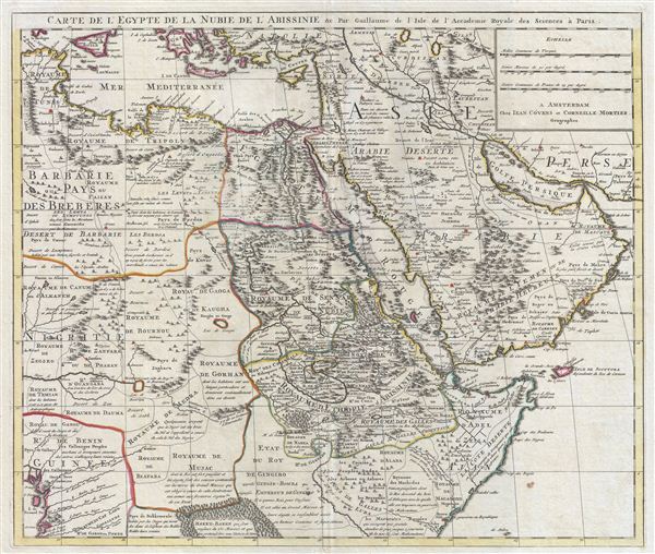
Carte de l'Egypte de la Nubie de L'Abissinie &c.
1730 (undated) 19.5 x 23.5 in (49.53 x 59.69 cm)
1730 (undated) 19.5 x 23.5 in (49.53 x 59.69 cm)
Description
A fine example of the 1730 Covens and Mortier issue of Guillaume de L'Isle's important 1707 map of Arabia, egypt, Nubia, and Abyssinia. Centered on the Red Sea and the Nile Valley, this extraordinary Map covers from the Bight of Benin and the Kingdom of Tunis (Tunisia) eastward as far as the Persian Gulf, inclusive of modern day Saudi Arabia, egypt, ethiopia, Sudan, Libya, Tunisia, the United Arab emirates, Oman, Qatar, Iraq, Somalia, Yemen, Cyprus, et al. The map is rendered in De L'Isle's distinctive and innovative style which eschewed the flamboyant Dutch map work of the previous century in favor the highly detailed, information rich, and decorative cartographic approach seen here.
De L'Isle is best known as a 'scientific cartographer' whose work often set the standard for most subsequent maps of whatever region he focuses on. This map is no exception and would remain the definitive picture of Arabia and the Nile Valley well into the early 19th century. even so, much of this area is only speculatively mapped and is largely unknown to european mapmakers. In Arabia De L'Isle based any of his cartographic advances on reports from diplomats, missionaries, and explorers, as well as on earlier Ottoman and Arabic maps in the French archives. In Africa, De L'Isle accessed similar reports as well as and hearsay that filtered up the Nile Valley from Christian enclaves in Abysinnia and Arab traders.
For example, the Kingdom of Gingiro, here located to the south and west of Abyssinia, is known from the reports of the Jesuit Anton-Fernandez who traveled to the region in 1613 on a mission for King Philip II of Spain. Anton-Fernandez offer a wealth of detail about the Kingdom nothing that Gingiro means 'monkey' in the local language and that the king himself a kind of monkey-God. One hundred years later, when De L'Isle drew this map, Anton-Fernandez's journal remained one of the few reports of this region available and, for want more up to date information, was incorporated. Most other regions of Africa beyond the well mapped Lower Nile Valley and Abyssinia, rely on equal vagarious references.
Published in the c. 1730 Covens and Mortier reissue of De L'isle's Atlas Nouveau.
CartographerS
The De L'Isle family (fl. c. 1700 - c. 1760) (also written Delisle) were, in composite, a mapmaking tour de force who redefined early 18th century European cartography. Claude De L'Isle (1644 -1720), the family patriarch, was Paris based a historian and geographer under Nicholas Sanson. De L'Isle and his sons were proponents of the school of "positive geography" and were definitive figures, defining the heights of the Golden Age of French Cartography. Of his twelve sons, four, Guillaume (1675 - 1726), Simon Claude (1675 - 1726), Joseph Nicholas (1688 - 1768) and Louis (1720 - 1745), made a significant contributions to cartography. Without a doubt Guillaume was the most remarkable member of the family. It is said that Guillaume's skill as a cartographer was so prodigious that he drew his first map at just nine years of age. He was tutored by J. D. Cassini in astronomy, science, mathematics and cartography. By applying these diverse disciplines to the vast stores of information provided by 18th century navigators, Guillaume created the technique that came to be known as "scientific cartography", essentially an extension of Sanson's "positive geography". This revolutionary approach transformed the field of cartography and created a more accurate picture of the world. Among Guillaume's many firsts are the first naming of Texas, the first correct map of the Mississippi, the final rejection of the insular California fallacy, and the first identification of the correct longitudes of America. Stylistically De L'Isle also initiated important changes to the medium, eschewing the flamboyant Dutch style of the previous century in favor of a highly detailed yet still decorative approach that yielded map both beautiful and informative. Guillaume was elected to the French Academie Royale des Sciences at 27. Later, in 1718, he was also appointed "Premier Geographe du Roi", an office created especially for him. De L'Isle personally financed the publication of most of his maps, hoping to make heavy royalties on their sales. Unfortunately he met an untimely death in 1728, leaving considerable debt and an impoverished child and widow. De L'Isle's publishing firm was taken over by his assistant, Phillipe Buache who became, posthumously, his son in law. The other De L'Isle brothers, Joseph Nicholas and Louis De L'Isle, were employed in the Service of Peter the Great of Russia as astronomers and surveyors. They are responsible for cataloguing and compiling the data obtained from Russian expeditions in the Pacific and along the northwest coast of America, including the seminal explorations of Vitus Bering and Aleksei Chirikov. The De L'Isles, like their rivals the Vaugondys , must be considered speculative geographers. Speculative geography was a genre of mapmaking that evolved in Europe, particularly Paris, in the middle to late 18th century. Cartographers in this genre would fill in unknown areas on their maps with speculations based upon their vast knowledge of cartography, personal geographical theories, and often dubious primary source material gathered by explorers and navigators. This approach, which attempted to use the known to validate the unknown, naturally engendered many rivalries. The era of speculatively cartography effectively ended with the late 18th century explorations of Captain Cook, Jean Francois de Galaup de La Perouse, and George Vancouver. More by this mapmaker...
Covens and Mortier (1721 - c. 1862) was an Amsterdam publishing firm, the successor to the extensive publishing empire built by Pierre Mortier (1661 - 1711). Covens and Mortier maps are often criticized as derivative - but this is not fully the case. Pierre Mortier lived in Paris from 1681 to 1685. There he established close relationships the the greatest French cartographers of the era, including De L'Isle and D'Anville. His business model was based upon leveraging Dutch printing technology and sophistication to co-publish state of the art French cartography. Upon Mortier's death in 1711 his firm was taken over by his son, Cornelius Mortier (1699 - 1783). Cornelius married the sister of Johannes Covens (1697 - 1774) in 1721 and, partnering with his brother in law, established the Covens and Mortier firm. Under the Covens and Mortier imprint, Cornelius and Johannes continued in Pierre's model of publishing the most up-to-date French works with permission. They quickly became one of the largest and most prolific Dutch publishing concerns of the 18th century. The firm and its successors published thousands of maps over a 120 year period from 1721 to the mid-1800s. During their long lifespan the Covens and Mortier firm published as Covens and Mortier (1721 - 1778), J. Covens and Son (1778 - 94) and Mortier, Covens and Son (1794 - c. 1862). Learn More...
Source
De L'Isle, G., Atlas Nouveau, Contenant Toutes Les Parties Du Monde, Ou sont exactement Remarquées les Empires, Monarchies, Royaumes, Etats, Republiques &c. Par Guillaume de l'Isle. Premier Géographe de sa Majeste, (Amsterdam, Covens and Mortier) c. 1730.
Condition
Very good condition. Original centerfold. Blank on verso.
References
Tibbetts, G. R., Arabia in Early Maps: A Bibliography of Maps Covering the Peninsula of Arabia, Printed in Western Europe from the Invention of Printing to the Year 1751, #199 and #241. Moreland, C., and Bannister, D., Antique Maps, a Collector's Handbook, page 267. Norwich, O. I., Norwich's Maps of Africa: An Illustrated and Annotated Cartobibliography, #298.