This item has been sold, but you can get on the Waitlist to be notified if another example becomes available, or purchase a digital scan.
1701 Delisle Map of the Arabia, Turkey and Persia
ArabiaTurquiePerse-delisle-1701$475.00

Title
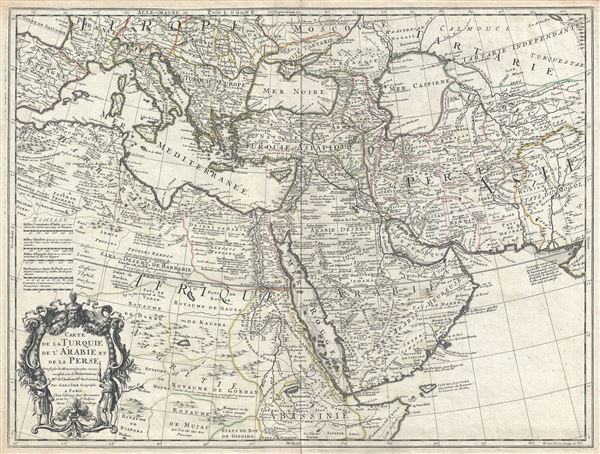
Carte de la Turquie de L'Arabie et de la Perse.
1701 (dated) 19 x 25 in (48.26 x 63.5 cm) 1 : 10550000
1701 (dated) 19 x 25 in (48.26 x 63.5 cm) 1 : 10550000
Description
A scarce first edition first state example of Guillaume De L'Isle's 1701 map of Arabia, Turkey, and Persia. This is a foundational map and may be considered the first modern map of the Arabian Peninsula, in which the vagaries of the Ptolemaic era were at last exchanged for a more sophisticated modern geography based on actual observation and scientific deduction. Centered on the Arabia, this map covers the entire Mediterranean Basin from Spain to Cyprus, and extends eastward into Asia as far as modern day Afghanistan and the Indus River Valley. It further extends from the Black and Caspian Seas south to the Horn of Africa and Abyssinia.
This map is exceptionally dense with a wealth of new and reconsidered information throughout. Its most significant advances appear in the Arabian Peninsula, for which this may be considered a foundational map. Previous maps of Arabia relied heavily on Ptolemaic influences dating to the 15th century. The present map, aided by a wealth of new cartographic data then flowing into Europe, particular Paris, is among the first to scientifically assess and reconsider the region. Delisle based most of his cartographic advances on first hand reports from diplomats, missionaries, and explorers, as well as on earlier Ottoman and Arabic maps in the French archives. Delisle has here refined most borders, removed double place names (a common error in earlier maps), reengineered various mountain ranges, and deleted questionable data. The Sheikdom of Bahrain, or 'Kingdom of Pearls' in reference to the region's rich pearl fisheries, is noted as occupying most of the Arabian portion of the Persian Gulf. This is the first map of Arabia in which rivers originating in mountains peter out before reaching the sea - one such example is the Sancon River not far south of Mecca. Another item of interest is the Aftan River. Though no river has flowed here for thousands of years, this river has recently been identified as an ancient trade route along the Wadi al-Sahba giving access to the Arabian interior. Delisle's map stood as the standard map of Arabia, being copied by numerous subsequent cartographers including, but not limited to, Chatelain, Covens and Mortier, and others, until the revolutionary work of D'Anville in 1752.
The Persia portion of this map also has much of interest and occupies nearly the entire northeastern quadrant. The Caspian Sea (Mer Caspiene) is particularly malformed but offers a minor update over the Sanson model. Here the Caspian Sea is slowly beginning to take on a north-south orientation, with the western shores being particularly well defined. The eastern shoreline remains vague and features a note by Delisle admitting that 'ces Costes no sont bas bien conniies' (these coasts are not well known). He offers excellent coverage of the central Asian portions of the Silk Route, drawing on Russian sources for mapping the centers of Samarkand, Bokhara and Fergana, known stopping points for Russian trade envoys to China. For the remainder of Persia, Delisle most likely updated archaic Persian and Arabic cartographic information with reports from Georgian and Armenian traders and mercenaries active throughout Persia. It may be through these sources that Delisle was able to add considerable geographic information regarding trade routes and place names in central Persia. These include such significant advances as the identification of Tehran (Taheran), the current capital of Iran, which is notably absent it earlier European maps of Persia.
The lower left quadrants of this map are dedicated to a rather interesting depiction of northeastern Africa from the Mediterranean shores to the Horn. To construct this part of the map Delisle accessed explorer and missionary reports as well as and hearsay that filtered up the Nile Valley from Christian enclaves in Abyssinia. He correctly asses the course of the Blue Nile placing its source at Lake Tana, (here Dambea) in modern day Ethiopia. However, he misaligns the lake, placing the regional capital Gondar (Gontar) to its east rather than north. The Ruins of Axum are identified just to the north of Gondar. Delisle offers a speculative course of the White Nile that postulates a confluence with the Niger - a popular theory of the period. A great lake, identified as 'Kaugha ou Gaoga' is most likely an early mapping of Lake Chad.
The map is rendered in Delisle's distinctive and innovative style which eschewed the flamboyant Dutch strapwork of the previous century in favor the highly detailed, information rich, and decorative cartographic approach seen here. There are at least five different editions of this map as well as numerous variants. The present example represents the first and earliest, engraved by H. van Loon and published in 1701. We are able to identify this as such because of the use of Rue des Canettes as Delisle's address, in 1702 he moved to Quai de Horlage. Also of note is the inscription 'C. Simonneau inv. Et fecit' just below the title cartouche. Simmonneau is responsible only for the decorative cartouche and his imprint was removed from all subsequent variants and editions.
CartographerS
The De L'Isle family (fl. c. 1700 - c. 1760) (also written Delisle) were, in composite, a mapmaking tour de force who redefined early 18th century European cartography. Claude De L'Isle (1644 -1720), the family patriarch, was Paris based a historian and geographer under Nicholas Sanson. De L'Isle and his sons were proponents of the school of "positive geography" and were definitive figures, defining the heights of the Golden Age of French Cartography. Of his twelve sons, four, Guillaume (1675 - 1726), Simon Claude (1675 - 1726), Joseph Nicholas (1688 - 1768) and Louis (1720 - 1745), made a significant contributions to cartography. Without a doubt Guillaume was the most remarkable member of the family. It is said that Guillaume's skill as a cartographer was so prodigious that he drew his first map at just nine years of age. He was tutored by J. D. Cassini in astronomy, science, mathematics and cartography. By applying these diverse disciplines to the vast stores of information provided by 18th century navigators, Guillaume created the technique that came to be known as "scientific cartography", essentially an extension of Sanson's "positive geography". This revolutionary approach transformed the field of cartography and created a more accurate picture of the world. Among Guillaume's many firsts are the first naming of Texas, the first correct map of the Mississippi, the final rejection of the insular California fallacy, and the first identification of the correct longitudes of America. Stylistically De L'Isle also initiated important changes to the medium, eschewing the flamboyant Dutch style of the previous century in favor of a highly detailed yet still decorative approach that yielded map both beautiful and informative. Guillaume was elected to the French Academie Royale des Sciences at 27. Later, in 1718, he was also appointed "Premier Geographe du Roi", an office created especially for him. De L'Isle personally financed the publication of most of his maps, hoping to make heavy royalties on their sales. Unfortunately he met an untimely death in 1728, leaving considerable debt and an impoverished child and widow. De L'Isle's publishing firm was taken over by his assistant, Phillipe Buache who became, posthumously, his son in law. The other De L'Isle brothers, Joseph Nicholas and Louis De L'Isle, were employed in the Service of Peter the Great of Russia as astronomers and surveyors. They are responsible for cataloguing and compiling the data obtained from Russian expeditions in the Pacific and along the northwest coast of America, including the seminal explorations of Vitus Bering and Aleksei Chirikov. The De L'Isles, like their rivals the Vaugondys , must be considered speculative geographers. Speculative geography was a genre of mapmaking that evolved in Europe, particularly Paris, in the middle to late 18th century. Cartographers in this genre would fill in unknown areas on their maps with speculations based upon their vast knowledge of cartography, personal geographical theories, and often dubious primary source material gathered by explorers and navigators. This approach, which attempted to use the known to validate the unknown, naturally engendered many rivalries. The era of speculatively cartography effectively ended with the late 18th century explorations of Captain Cook, Jean Francois de Galaup de La Perouse, and George Vancouver. More by this mapmaker...
Harmanus van Loon (fl. c. 1690 - c. 1725) was a Flemish engraver active in Paris during the late 17th and early 18th centuries. Van Loon worked primarily in Paris and often signed his work, which includes maps and other engravings for such prominent cartographers as Nicolas de Fer, Jean Baptiste Nolin, Guillaume Delisle, and others. There is some speculation that he may have been related to the Brussels born painter Theodorus van Loon. Learn More...
Condition
Very good. Original centerfold exhibits some wear.
References
Tibbetts, G. R., Arabia in Early Maps: A Bibliography of Maps Covering the Peninsula of Arabia, Printed in Western Europe from the Invention of Printing to the Year 1751, #171. Rumsey 4764.075.