1848 Kiepert Map of the Arabian Peninsula
Arabien-kiepert-1848-2$1,500.00

Title
Arabien.
1848 (dated) 22 x 21.5 in (55.88 x 54.61 cm) 1 : 5500000
1848 (dated) 22 x 21.5 in (55.88 x 54.61 cm) 1 : 5500000
Description
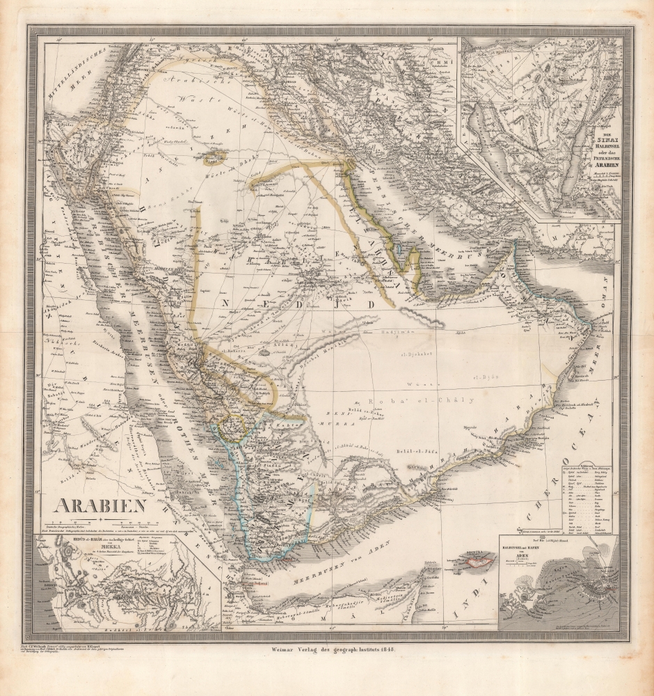
This is an 1848 Heinrich Kiepert map of the Arabian Peninsula. It displays the region, only poorly understood by Europeans, in impressive detail. Of note is the controversial term 'Pirate Coast' (roughly the UAE), and the route of Finnish Arabist George August Wallin.
A Closer Look
Coverage embraces from eastern Africa to Isfahan and from Lebanon, Syria, and Iraq to the Horn of Africa and the Indian Ocean. Coastlines are labeled, along with cities, including Mecca, Medina, and Riyadh (Er-Rijid). Debai (Dubai) and Abuthubbi (Abu Dhabi) are also named. Qatar is shown as Bahrein, with El Biddah (Doha) and a number of other Qatari place names are identified.Historical Context
When this map was issued much of this region fell under the Ottoman suzerainty. Nonetheless, the central and southern part of the peninsula is shown as Wahabiten Nedjd (Wahabi Emirate of Nejd). Nejd was the Second Saudi State, lasting from 1819 to 1891, which rose from the 1818 fall of the Emirate of Dirijay. The map follows closely on 1843 the Imam Faisal bin Turki bin Abdullah Al Saud (1785 - 1865)'s return to power.Pirate Coast
The coastline from Debai (Dubai) to the Strait of Hormuz is here labeled 'Piraten Kuste' or 'Pirate Coast'. This region was considered a hotbed of piracy in the 17th century, when local Al Qasimi (the ruling families of Sharjah and Ras Al Khaimah) and other tribal groups adopted raiding to support themselves in the barren climate. The area was also frequented by European pirates who found pilgrim ships from India en route to Mecca particularly profitable targets. The British began a heavy-handed crack-down on the Al Qasimi between 1809 and 1819. The Al Qasimi were forced to sign the General Maritime Treaty of 1820, which forbid piracy against British vessels and outlawed slavery in general.Wallins Reise
The map notes 'Wallins Reise 1848', the route taken by Finnish explorer George August Wallin (1811 - 1852). Wallin was an orientalist and a scholar. Disguised as a Muslim pilgrim under the assumed name, Abd al-Wali, Wallin explored Arabia from 1843 to 1848. His first expedition took him from Cairo to Ma'an, Al Jauf, Jubba, Ha'il, Medinah, Mecca, and Jiddah - making him one of the first European to see some of these cities. His second expedition (1846 - 1848) took them through Palestine and Arabia to Persia. His work was highly influential in opening the Arabian world to European scholarship, and thus is unsurprising to have been one of Kiepert's primary sources. What is surprising is how quickly data from the Second Wallin Expedition was committed to cartographic print. Wallin's success came at a high price. Within a couple of years after his return to Europe, he found himself unable to re-adapt, finding Finnish life closed and oppressive. He died suddenly in 1852 of unknown causes.Publication History and Census
This map is based on a groundbreaking 1841 map of the region by Carl Ferdinand Weiland, which was then 'completely reworked' (völlig umgearbeit) by Heinrich Kiepert and published by the Geographishces Institut in 1848. It is noted as being intended for use with Carl Ritter's Vergleichende Erdkunde von Arabien, which was published the previous year. The map is quite rare, only being cataloged among the holdings of the University of Chicago, while later editions, which the Geographishces Institut issued into the 1860s, are held by a handful of universities in North America and Europe.CartographerS
Heinrich Kiepert (July 31, 1818 - April 21, 1899) was a German cartographer and historian active in the mid to late 19th century. Kiepert was born into generous circumstances that allowed him to develop his childhood interest in geography and history into a serious profession. The Berlin-born Kiepert traveled widely in his youth, and was encouraged in his studies by the historian Leopold von Ranke, a family friend. He was a student of classical antiquity under August Meineke and worked with Cal Ritter. He studied history, philology, and geography at the Humboldt University of Berlin - he would eventually teach geography there, and would remain there until his death. Disappointed with the poor quality of maps in historical school books, Kiepert set out to correct the problem. His first major work, the Atlas von Hellas und den hellenischen Kolonien, was published with Karl Ritter in 1840. The work immediately won accolades from the academic community. A number of similar publications followed, including the 1848 Historisch-geographischer Atlas der alten Welt, the 1854 Atlas Antiquus, and the 1894 Formae Orbis Antiqui. Kiepert specialized in the historical geography of the classical world at the University of Berlin. This developed into a geographical interest in the Ottoman Empire - which at the time was poorly mapped. He traveled to Asia Minor four times between 1841 and 1848, using his travels to collect and compile geographical data, producing several outstanding regional maps with wide-ranging coverage extending from the Mediterranean to the Caucasus. Thanks in large part to these works, Kiepert became the recognized expert on Ottoman geography, his works representing the best obtainable reconnaissances of their respective regions. From 1845 until 1852, Kiepert served as the head of the Geographisches Institut in Weimar. In 1854 he took a position as professor of Geography at the University of Berlin and for nearly 50 years was considered the go-to man with regard to the cartography of classical and biblical antiquity. Kipert formed a long-lasting professional association with Dietrich Reimer, a publisher in Berlin. Kiepert's maps are known for b being clear, easy to read, and as accurate as possible for the time in which they were produced. In addition to his landmark work in mapping the Ottoman Empire, Kiepert also published the first detailed ethnic maps of Austria-Hungary, the Balkan Peninsula, and Germany. Kiepert died in Berlin on April 21 of 1899. More by this mapmaker...
Carl Ferdinand Weiland (1782 - 1847) was a German cartographer active with the Weimar Geographisches Institut, where he headed up map and globe production, in early and middle part of the 19th century. Weiland was a trained as a military cartographer who, with his career at the Geographisches Institut, move into the private market. Among his other work, Weiland issued a German edition of Carey and Lea's American Atlas. Their edition, which was fully re-engraved in Germany, is of superior workmanship and stands out as some of the finest 19th century maps of individual U.S. states printed outside of America.Carl Ferdinand Weiland (1782 - 1847) was a German cartographer active with the Weimar Geographisches Institut, where he headed up map and globe production, in early and middle part of the 19th century. Weiland was a trained as a military cartographer who, with his career at the Geographisches Institut, move into the private market. Among his other work, Weiland issued a German edition of Carey and Lea's American Atlas. Their edition, which was fully re-engraved in Germany, is of superior workmanship and stands out as some of the finest 19th century maps of individual U.S. states printed outside of America. Learn More...
Geographisches Institut, Weimar (fl. 1804 - c. 1903) was a German map and globe publishing house and geographical research institute based in Weimar. The organization primarily focused on republishing and improving upon the works of earlier cartographers, including Kitchin, Jefferys, Carey, and others. In general, its publications are known for their fine engraving, attention to detail, historical accuracy, and overall high quality. The firm was founded in 1804 by Friedrich Justin Bertuch (???? - c. 1845) and, on his death, passed to his son Robert Froreip (???? - 1855), then to Louis Denicks of Luneberg, then in 1859 to Voigt & Günther, in 1883 to F. Arnd, from 1890 - 1893 to Julius Kettler, and in 1903 to Max Wedekind. During the institute's height in the early 19th century, most of its cartographic publication was overseen by Carl Ferdinand Weiland (1782 - 1847). The firm also employed the cartographers Franz Xaver von Zach, Adam Christian Gaspari, Heinrich Kiepert, Karl (or Carl) and Adolf Graef, Julius Kettler, Carl Riemer and Karl Christian Bruhns. Weimar was a logical place for a collective like the Geographisches Institut to arise; it was a cultural mecca in the German-speaking world in the late 18th and 19th centuries because of its liberal atmosphere and associations with figures like Schiller, Herder, and, above all, Goethe, who spent most of his adult life in the city. Learn More...
Condition
Very good. Two sheets joined together, seam visible. Minor discoloration and toning in margins.
References
Rumsey 2077.045. OCLC 55073355.