This item has been sold, but you can get on the Waitlist to be notified if another example becomes available, or purchase a digital scan.
1901 U.S. War Department Map of the Philippines
ArchipielagoFilipino-wardept-1901$600.00


Title
Carta General (en dos hojas) del Archipiélago Filipino.
1901 (dated) 52 x 38 in (132.08 x 96.52 cm) 1 : 1600000
1901 (dated) 52 x 38 in (132.08 x 96.52 cm) 1 : 1600000
Description
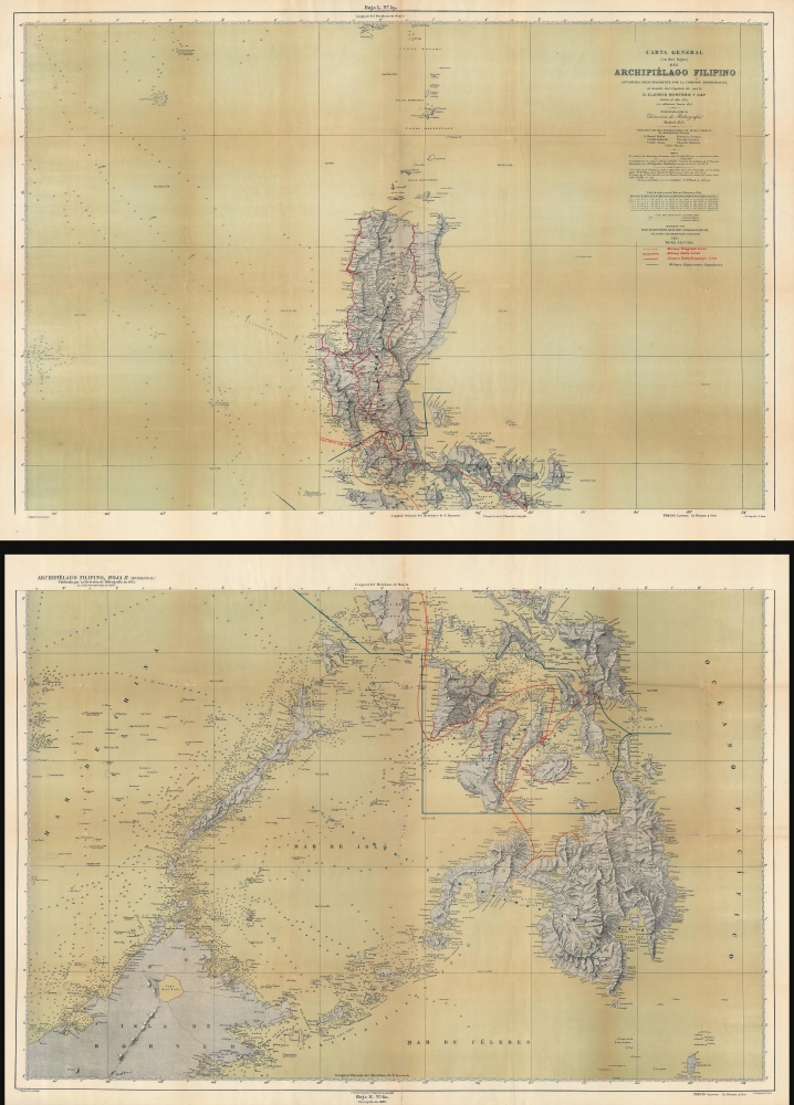
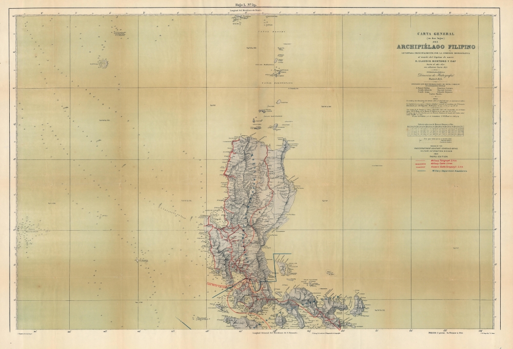
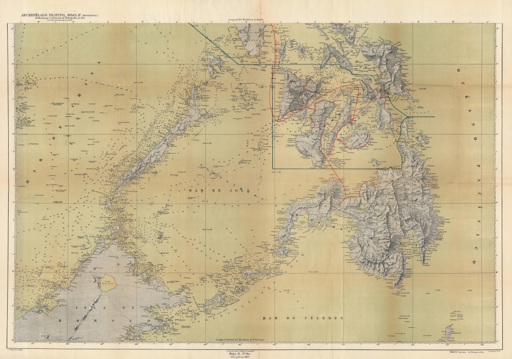
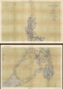
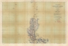
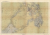
This is a 1901 U.S. War Department map of the Philippines. Published during the Philippine-American War (1899 - 1902), the War Department repurposed a Spanish Direccion Hidrografia map originally published in 1870.
Military Communications
Created by the Military Information Division of the War Department, red and blue overprinting highlights communication lines and military departments within the Philippines. Solid red lines illustrate military telegraph lines. This network is most fully developed on Luzon, but decent networks also exist on Panay, Negros, Cebu, Leyte, and Bohol. Underwater military cables are used on Luzon and between Cebu and Mindanao and are illustrated using similar solid red lines. Undersea cables operated by the Eastern Cable Company connect the islands and connect Manila with Hong Kong. Solid blue lines divide the Philippines into military districts.A Closer Look
Aside from the military communications network highlighted by the U.S. War Department, cities, towns and villages are identified throughout Luzon, with fewer villages appearing on the other islands in the archipelago, with the exception of Mindanao, which had a surprising lack of U.S. military presence. Coastal points, bays, and other locations are noted, along with rivers, mountains, and other physical features. Innumerable depth soundings appear throughout the islands, with the highest concentrations appearing in straits and along coastlines, mostly in bays.The Philippine-American War
The Philippine-American War lasted from February 4, 1899, until July 2, 1902, when the Philippine Organic Act established the Second Philippine Commission and Philippine legislature. The war immediately followed the Spanish-American War, once the Filipinos realized that the Americans were in the islands to stay. Estimates of Filipino civilian casualties vary wildly, from at least 200,000 to over one million, the majority of which were caused by famine and disease. Armed resistance to the U.S. occupation of the Philippines continued as a guerrilla insurrection in many parts of the archipelago until June 1913. The U.S. passed the Tydings-McDuffie Act, also known as the Philippine Independence Act, in 1934. This law created the Commonwealth of the Philippines, increased self-governance, and scheduled Philippine independence for 1944. World War II delayed this process, and the U.S. did not grant full independence to the Philippines until 1946.Publication History and Census
This map was originally created by Juan Noguera with letter engraving by Juan de Gangoiti and published by the Direccion Hidrografia in 1870, with updates in 1875. Another updated edition was published by the Direccion Hidrografia in 1888. Then, during the Phillipine-American War (1899 - 1902), the Military Information Division of the Adjutant General's Office of the U.S. War Department issued three editions: 1899, 1900, and 1901. The present example represents the 1901 edition. We note a dozen examples of what appears to be the 1901 edition cataloged in OCLC, however, due to cataloging inconsistencies, it is evident that not all twelve of those examples are in fact 1901 editions, making a true census of surviving examples much more difficult.CartographerS
Juan Noguera (fl. c. 1835 – 1870) was a Spanish draftsman and engraver based in Madrid during the middle part of the 19th century. Noguera drafted and engraved maps for Francisco Coello, Direccion de Hidrografia, and others. Juan Noguera should not be confused with Clemente Noguera, who was also a senior line-engraver at the Direccion de Hidrografia. The two engravers may or may not be related. Clemente was significantly older than Juan, and may have been an older relative. More by this mapmaker...
Juan de Gangoiti (July 12, 1816 - February 8, 1878) was a Spanish artist, map, and letter engraver, the son of the Spanish artist and engraver Pedro Manuel de Gangoiti (February 16, 1759 - August 15, 1830). He studied engraving under his father and then, when his father died, under his brother, Nicolás de Gangoiti (September 30, 1801 - January 6, 1857). He did extensive engraving work for the government of Spain, the Depósito Hidrográfico, and other agencies. He worked on maps, seals and jewelry. In the final days if his life, he served as a caretaker for the Real Academia de San Fernando (Royal Academy of San Fernando). Learn More...
Pascual Serra y Mas (fl. c. 1853 - 1883) was a Spanish line and letter engraver engaged with the Direccion de Hidrografia or Deposito Hidrografico in the second half of the 19th century. Learn More...
E. Fungairiño (1838 - 1916) was a Spanish engraver associated with the Direccion Hidrografia who often engraved topography. Learn More...
The Direccion Hidrografía (1787 - 1927), also known as the Deposito Hydrografico and the Direction de Hidrografía, was the Spanish equivalent of the British Admiralty or the U.S. Coast Survey. This organization, founded in 1787, was commissioned to collect and produce accurate nautical charts of all waters frequented by Spanish vessels. In essence, it replaced the Casa de la Contratación de las Indias (House of Trade of the Indies), which closed its doors in 1790. Like most such organizations, the Direccion Hidrografía marked a new age in cartography. Rather than simply collect charts created by navigators, explorers, and merchants, the Direccion Hidrografía worked closely with naval and military personnel to mount cartographic and hydrographic expeditions in pursuit of the most accurate hydrographical, astronomical, and geodetic measurements. The Direccion Hidrografía created a massive library of nautical charts that, though not nearly as common as similar nautical charts by the U.S. Coast Survey and British Admiralty, are highly desirable for the beauty of their manufacture as well as their accuracy and detail. The office was originally located on Calle Ballesta, but relocated to 36 Alcala, both in Madrid. After 1908 the Dirección was subsumed into other governmental agencies. In 1927 the Direccion was absorbed into the Institute and Observatory of San Fernando, located in Cadiz. The library of original maps, charts, and journals was transferred to the Naval Museum of Madrid - where it resides to this day. Learn More...
Condition
Average. Two sheets. Wear and toning along original fold lines to both sheets. Infill at fold intersections to both sheets. Verso repairs to fold separations to both sheets. Closed margin tears professionally repaired on verso to both sheets.
References
OCLC 74496803.