1876 Seelstrang / Tourmente Communications and Transportation Map of Argentina
Argentina-seelstrang-1876$375.00

Title
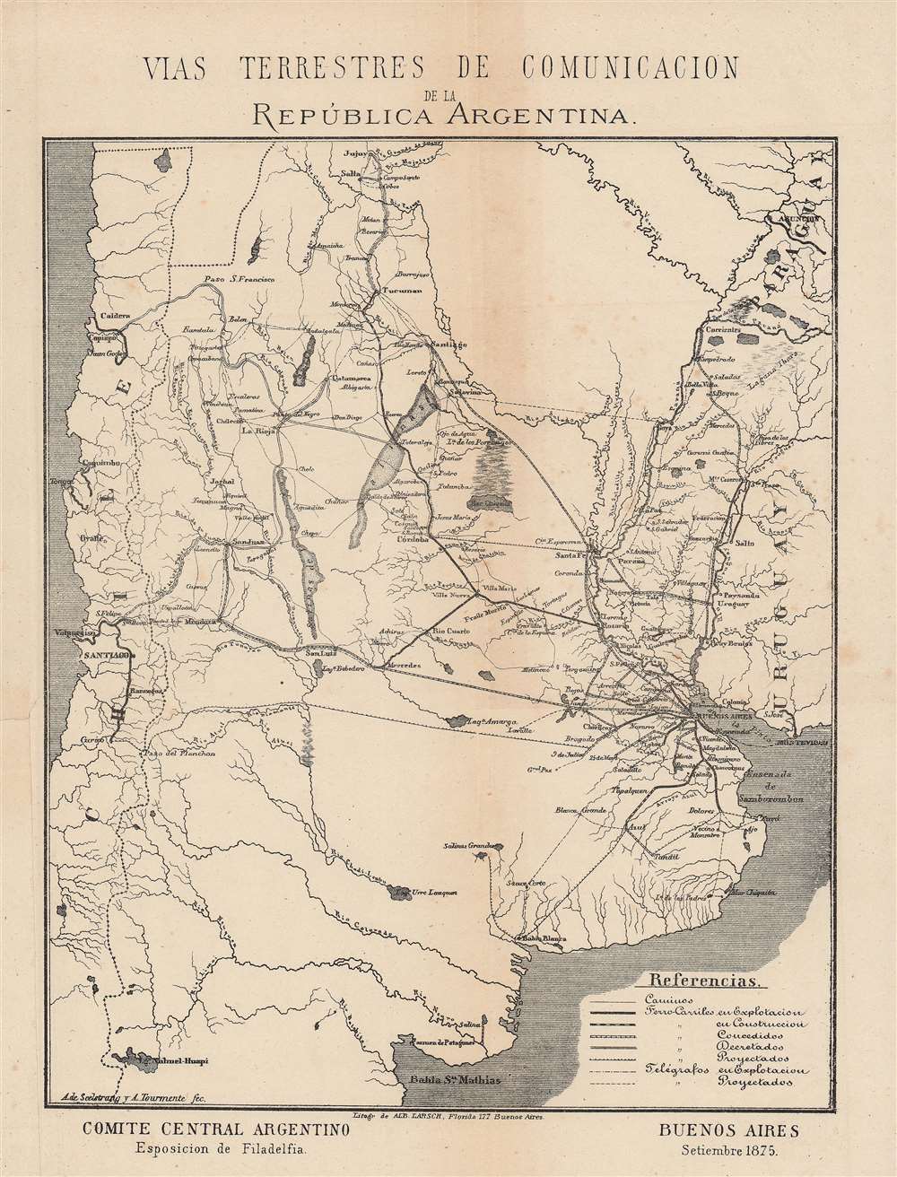
Vias terrestres de Comunicacion de la República Argentina.
1876 (undated) 9.75 x 8 in (24.765 x 20.32 cm) 1 : 8000000
1876 (undated) 9.75 x 8 in (24.765 x 20.32 cm) 1 : 8000000
Description
This is an 1876 map of communications and transportation in Argentina by Arturo Seelstrang, one of the most prominent Argentinian geographers of his generation. It was produced for the Philadelphia Centennial Exposition to highlight the development and modernization of Argentina.
Continued fighting with native peoples led to the construction of the 'Zanja de Alsina,' named for the Minister of War at the time of this map's publication, consisting of a massive trench reaching roughly from Bahía Blanca to San Luis, with forts and military posts at regular intervals. In the following years, a new campaign ('The Conquest of the Desert') was carried out to fully control or eliminate indigenous groups in the Pampas and Patagonia, a development which was followed by the construction of even more railways, including the establishment in 1909 of Ferrocarriles del Estado, tasked with settling Patagonia. In addition to suppressing opposition by indigenous groups, expansion into newly opened lands was also a convenient way to alleviate the effects of the Panic of 1873 and the resulting economic crisis, as well as allowing for the development of the country's large agricultural market.
The line between San Juan and Valparaiso, shown here as 'granted,' was not completed, as it would have been redundant given the lines from Mendoza to both Valparaiso and San Juan. An extension of the Buenos Aires Great Southern Railway that would have reached Chile was considered in the early 20th century but was never built, while a route connecting the two countries to the south of the area depicted here was partially built in the early 21st century, but work has been abandoned.
A Closer Look
This map notes roads, telegraphs (in operation and projected), and railways in several states of completion, from already in operation to under construction, granted, decreed, and projected. Waterways are also indicated, giving some sense of the tremendous engineering challenges facing any prospective railways, particularly in the Andes. Railways reach across the continent, emanating out from Buenos Aires, even stretching to Argentina's great rival, Chile. At this time, Argentina had a combination of private railways owned by joint-stock companies, generally dominated by British investors, a system of state-owned railways, and state-financed ferrocarriles de fomento (development railways) in rural areas.Railways and Settler Colonialism
The railway network detailed here was critical in facilitating military campaigns and colonial settlement to control the frontier. The expansion of white settlers into Indian territory became more intense and violent after Argentina attained independence and consolidated as a confederation in the 1820s. The Desert Campaign (1833 - 1834) subdued, expelled, or exterminated indigenous groups in the areas to the immediate south and west of Buenos Aires. In the years afterwards, railways were used to move settlers, goods, and troops between the capital and the Pampas.Continued fighting with native peoples led to the construction of the 'Zanja de Alsina,' named for the Minister of War at the time of this map's publication, consisting of a massive trench reaching roughly from Bahía Blanca to San Luis, with forts and military posts at regular intervals. In the following years, a new campaign ('The Conquest of the Desert') was carried out to fully control or eliminate indigenous groups in the Pampas and Patagonia, a development which was followed by the construction of even more railways, including the establishment in 1909 of Ferrocarriles del Estado, tasked with settling Patagonia. In addition to suppressing opposition by indigenous groups, expansion into newly opened lands was also a convenient way to alleviate the effects of the Panic of 1873 and the resulting economic crisis, as well as allowing for the development of the country's large agricultural market.
Trans-Andean Railways
Building a railway through the Andes was among the greatest engineering challenges facing railway engineers in this era, requiring innovative solutions and steely determination. Two Trans-Andean lines were ultimately completed, though decades after this map's publication, the Transandine Railway and the Salta-Antofagasta Railway. The Transandine Railway is currently defunct, though plans are underway to restore it (and overcome problems caused by break of gauge, as some sections used narrow gauge to deal with the steep and difficult terrain). The Salta-Antofagasta railway fully opened in the late 1940s and is mostly used for freight.The line between San Juan and Valparaiso, shown here as 'granted,' was not completed, as it would have been redundant given the lines from Mendoza to both Valparaiso and San Juan. An extension of the Buenos Aires Great Southern Railway that would have reached Chile was considered in the early 20th century but was never built, while a route connecting the two countries to the south of the area depicted here was partially built in the early 21st century, but work has been abandoned.
Publication History and Census
This map was published to accompany the book Die Argentinische Republik, im Auftrag des Argentin-Central Comité's für die Philadelphia-Ausstellung (also published in Spanish and English). It was made in December 1875 by Arturo Seelstrang and A. Tourmente (no further information is available on this individual) and lithographed by Alberto Larsch. It is held by the Biblioteca Nacional de Uruguay and the British Library and is very scarce to the market.CartographerS
Arturo Seelstrang (May 1838 – November 30, 1896), sometimes as 'de Seelstrang' or 'von Seelstrang,' was a Prussian-born Argentinian mathematician, cartographer, and geographer. He arrived in Argentina in 1863 and spent the first part of his career conducting topographical surveys for different railway companies. Due to his accomplishments in exploring and surveying, he was invited to serve as a Professor of Topography and later a Dean of the Faculty of Physical-Mathematical Sciences of the National University of Córdoba. In 1880, Seelstrang was appointed a member of the National Academy of Sciences (Academia Nacional de Ciencias) and two years later he joined as a member of the Board of Directors. He was also a member of the Argentine Geographical Institute (Instituto Geográfico Argentino). Among his most important contributions were the Atlas of the Argentine Republic (Atlas de la República Argentina) and the 'Hypsometric map of the Argentine Republic' ('Mapa hipsométrico de la República Argentina'). More by this mapmaker...
Alberto Larsch (fl. c. 1875 – 1895) was a map printer active in Buenos Aires in the late 19th century who often lithographed maps by the prominent topographer and geographer Arturo Seelstrang. Learn More...
Source
Napp, R., Die Argentinische Republik, im Auftrag des Argentin-Central Comité's für die Philadelphia-Ausstellung, (Buenos Aires: Sociedad anonima) 1876.
Condition
Good. Repaired tear at left-center. Sporadic foxing.
References
OCLC 556399022.