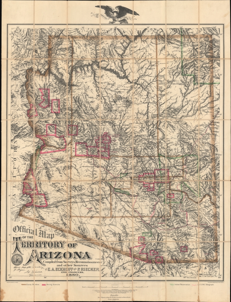
1880 Eckhoff Official Map of the Territory of Arizona
Arizona-eckhoff-1880$19,000.00


Title
Official Map of the Territory of Arizona.
1880 (dated) 32.5 x 27.75 in (82.55 x 70.485 cm) 1 : 823600
1880 (dated) 32.5 x 27.75 in (82.55 x 70.485 cm) 1 : 823600
Description
This is the first official map of Arizona Territory, published in 1880 by Emil A. Eckhoff and Paul Riecker. Rumsey calls this 'one of the best maps of Arizona as a territory.' It represents the primary cartographic resource during one of the most exciting and romantic periods of Arizona's history - recording the Arizona Silver and Copper mining boom, the early development of the territory's infrastructure and railroads, and the era of frontier lawlessness marked by the Gunfight at O.K. Corral, and other similar events.
A Closer Look
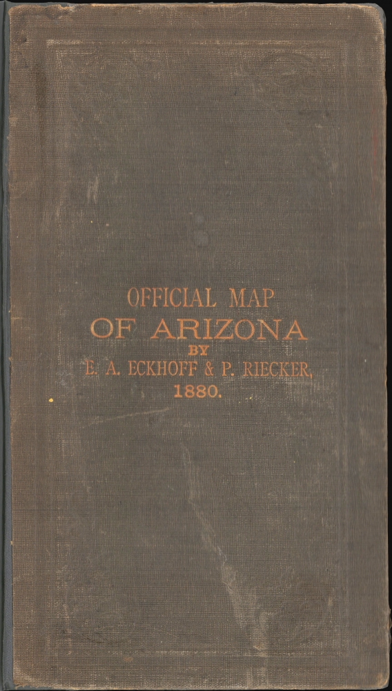
As described by the April 30, 1880 Arizona Daily Star:The Star is in receipt of a map of Arizona, published by Eckhoff and Recker [Riecker]. We have examined it carefully and do not hesitate in saying it is by far the most correct and exhaustive map yet published of our territory; and as such is of great value to all who take interest in Arizona. The map is constructed on a scale sufficiently large to admit every detail, exhibit the entire hydrographic system and the topography in clear relief, altitudes according to accepted authorities, public surveys (townships) as far as run; locations of towns, settlements, ranches, mines mining-camps, mills post offices, all roads and stations, telegraph lines and offices, military and Indian reservations, pueblos, etc. Especial attention has been given to the location of Mines and Mining Districts the boundaries of which, together with County and Reservation Lines, are distinguished by appropriate coloring, along the several roades [sic] and between stations, or other prominent points, the distances in miles and fractions are distinctly printed, converting the map into a graphic itinerary, more comprehensive and useful than the most elaborate classification in its usual from, an advantage which every traveler will readily appreciate.According to a period advertisement, the map was offered folded and bound, dissected and mounted on linen (as here), or on linen as a wall map.
Historical context
When this map was issued, the explorer and military officer John C. Fremont (1813 - 1890) was serving as the territorial governor - his facsimile signature appears in the lower left, underscoring the map's 'official' status. The Arizona Territory, at this time, was embarking on a period of burgeoning growth, spurred by the discovery of rich silver and copper deposits and the development of the Southern Pacific Railroad (at this time, it terminated at Tucson). The mineral wealth drew miners, prospectors, entrepreneurs, and rough-and-ready fortune-hunters from across the United States and beyond, lending the period its characteristic wild frontier spirit and lawlessness. Towns like Tombstone and Prescott (where both Eckhoff and Riecker were initially based) grew from small settlements into bustling centers of commerce, though not without the accompanying challenges of violence and conflict epitomized by the Gunfight at the O.K. Corral, and similar episodes. Amidst this backdrop of economic opportunity and social turmoil, the period was also marked by escalating conflicts between settlers and indigenous peoples, whose lands and rights were increasingly a matter of local and national conflict.Publication History and Census
This map was compiled and drawn in 1880 in Tucson, Arizona, by civil engineers Emil A. Eckhoff and Paul F. Riecker. It was published under the imprint of 'Eckhoff and Riecker' and printed in New York by the Graphic Company. Examples are rare. We note perhaps three physical holdings in the OCLC, two of which are in Arizona and the other in the David Rumsey collection. All other holdings seem to be digital-only. Rare to the market.CartographerS
Emil A. Eckhoff (1850 - 19??) was an Austrian-American mineral surveyor, mining engineer, and civil engineer active in Arizona in the late 19th century. Eckhoff was born in Austria. It is unclear when he emigrated to the United States, but it must have been before 1876. He enlisted in the U.S. Army in Philadelphia in 1876 and, upon the expiration of his first term in 1878, re-enlisted in San Francisco. He transferred to Fort Whipple, Arizona, where he served as a Topographical Assistant. Eckhoff was discharged from service in 1800 and settled in Prescott, Arizona, where he worked as a civil engineer and public notary. That same year, he was appointed Deputy U.S. Surveyor and Agent in Central Arizona for the American Bureau of Mines. He is best known for his publication with Paul Reicker (1851 - 1936), in 1880, of the first official map of the Territory of Arizona. He also prepared a map of Prescott, Arizona. Curiously, by May 15th of 1880, Eckhoff and Riecker dissolved their partnership, with Riecker purchasing Eckhoff's interest in the map. Eckhoff went on to work first as an engineer with the Arizona Central Railroad, then with the Southern Pacific Railroad. The date of his death is unknown. More by this mapmaker...
Paul Friedrich Riecker (March 2, 1851 - January 31, 1936) was a German-American explorer, surveyor, civil engineer, and mining engineer. Riecker was born in Baden-Württemberg, Germany. He studied civil engineering at the Hochschule für Technik Stuttgart. He immigrated to the United States between 1870 and 1872 for unclear reasons. He promptly enlisted in the U.S. Army, serving from 1873 to 1880. He led an early exploration party across the Colorado Plateau and was among the first to make contact with the Havasupai at the Grand Canyon. With his civil engineering training, he operated as a draughtsman for the Army in San Francisco until 1876. In 1877, he was reassigned to Fort Whipple, Yavapai, Arizona. Riecker retired from military service in 1880, taking a position in Tucson as a draftsman with the Surveyor' General's Office. In this capacity, along with Emil A. Eckhoff (1850 - 19??), he compiled the first official map of Arizona, published in 1880. Riecker went on to map Pasadena, California, in 1896. He also laid the street plans for both Inglewood and Redondo Beach, California. He was also involved in the Panama-Nicaragua Canal controversy as one of the original surveyors of the Nicaragua Canal route. In his later years, he moved to Oroville, California. Learn More...
Graphic Company (1872 - 1890), or The Graphic Company, was a New York City based printing house in the latter half of the 19th century. The company was founded by the brothers James H. Goodsell and C. M. Goodsell. The Goodsell Brothers were born in Michigan and, for a time, ran a printing business in Chicago, which they lost during the 1871 Great Chicago Fire. They moved to New York in 1872, drawing investors and founding The Graphic Company with $500,000 USD in investment capital, much of it from Canada where it was publically traded. Among their investors were the prominent Republicans Alexander Robey 'Boss' Shepherd and Benjamin Franklin Butler. It was originally created as a newspaper, The Daily Graphic, but quickly expanded to other forms of printing. In 1873, they concocted a publicity stunt to build a giant branded balloon to send aeronauts John Wise and Washington H. Donaldson across the Atlantic in just 60 hours – an attempt that ended in disaster in a Connecticut field just 120 miles from its starting point. By 1874, The Graphic Company advertised as general lithographers, engravers, and power press printers, with specializations in commercial lithography (stock certificates, checks, notes, etc), presentation cards, chromolithography, and photo-lithography. Within a year, they had become a large and successful printing house, largely due to large government printing contracts that may have been dubiously obtained, possibly through investors Sherman and Butler. In 1878, they introduced an additional periodical, The Weekly Graphic. The Goodsells sold their shares in The Graphic Company by at least 1886. By 1888, the company changed its name to the American Graphic Company. In 1889, it was advertised as the Graphic Publishing Company. For most of its operation, the company was located at 39-41 Park Place, New York. The firm was dissolved by court order in March of 1890. The Goodsell Brothers were also, from 1872, publishers of the Financier, a successful financial journal based at 156 and 158 Broadway, and the Insurance Spectator. Learn More...
Condition
Very good. Dissected and laid on linen. Minor margin discoloration. Accompanies original binder.
References
Rumsey 2980.001. Streeter, #526. Phillips (Maps ) #123. Storm, Colton, A Catalogue of the Everett D. Graff Collection of Western Americana, #1204.