
This item below is out of stock, but another example (left) is available. To view the available item, click "Details."
Details
1952 Arnold Pictorial Map of the United States as Arizonans See It
1952 (dated) $500.00
1947 Arnold Map of the United States as Arizonans See It
ArizonansUS-arnold-1947$250.00

Title
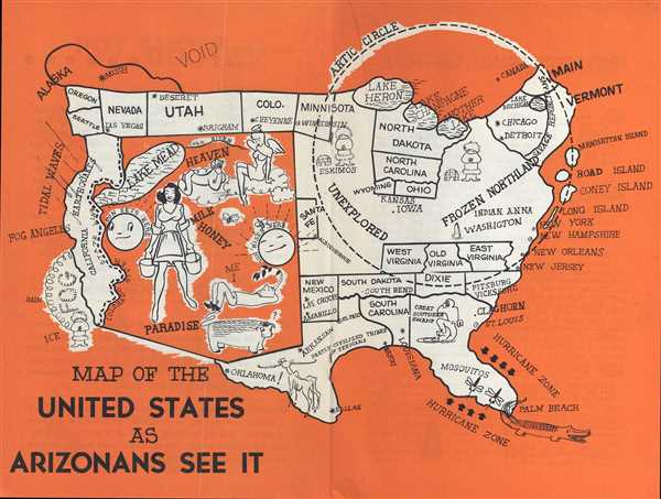
Map of the United States as Arizonans See It.
1947 (undated) 8.25 x 10.75 in (20.955 x 27.305 cm) 1 : 21964800
1947 (undated) 8.25 x 10.75 in (20.955 x 27.305 cm) 1 : 21964800
Description
This is a 1947 Oren Arnold and Leigh St. John humorous pictorial map of the United States. The map depicts the continental United States (relatively speaking) from the Pacific Ocean to the Atlantic Ocean and from Canada to Mexico from an Arizonan's perspective. Arizona, naturally, dominates the landscape. The state is referred to as 'heaven', 'paradise', and the '[land of] milk and honey'. Heaven is illustrated by a heavenly female angel, while a female farm hand carrying two pails escorted by two bees portrays the 'milk and honey' image. The sun also rises and sets in Arizona, a subtle suggestion that the universe revolves around the state. Lake Mean, of course, occupies a large portion of the upper-left corner of the state. A large bull, illustrated in the lower portion of Arizona, gazes quizzically across the state line at a fellow bull in Oklahoma / Texas. The Arizona bull's cousin, however, is not as well-fed, and is actually illustrated as being only skin a bone, yet another not-so-subtle hint at Arizona's claim to being paradise.
The rest of the map is occupied by a rather comical illustration of the United States, California, for example, is known for its earthquakes, tidal waves, rain, fog, and ice (complete with an Eskimo in winter weather gear). The Great Lakes are made up of Lake Heron, Lake Champagne, Another Lake, and Lake Michigan (which is in New England) near Chicago and Detroit. North Dakota and North Carolina border these lakes, while South Dakota and South Carolina are illustrated along the Gulf Coast. The vast majority of the Eastern U.S. is an 'Unexplored Frozen Northland inside the Arctic Circle. This includes the states of West Virginia, Old Virginia, and East Virginia. St. Louis is labeled along the Atlantic coast, while Florida is unlabeled, except as a hurricane zone, and as a habitat for mosquitos and alligators. Washington, D.C. is labeled, along with a sketch of the Washington Monument. While Coney Island, 'Road' Island, Manhattan Island, and Long Island all exist off the Atlantic coast. Canada, for its part, is simply labeled as 'void'.
This map was created by Leigh St. John and included in Oren Arnold's 1947 booklet 'Arizona Brags'. St. John undoubtedly took inspiration for their creation from Daniel Wallingford, famous for his map A Bostonian's Idea of the United States of America.
Cartographer
Oren Arnold (July 20, 1900 - 1980) was an American novelist, journalist and humorist. Born in Minden, Texas, Arnold attended Rice University were he was the editor of the student newspaper, the 'Thresher', president of the Writers Club, and the Rice correspondent for the 'Houston Chronicle'. After leaving Rice, Arnold worked briefly as a newspaper reporter and editor in Texas and Arizona in the 1920s, although he found more success through his freelance efforts. He spent more than the following fifty years as a full-time free-lance writer and traveler. He accomplished most of his writing at his home in Phoenix, Arizona or at his beach cottage in Laguna Beach, California. More by this mapmaker...
Source
Arnold, O. Arizona Brags: Explosive Information about the Sunshine State., (Phoenix: The Bargeo Press) 1947.
Condition
Very good. Even overall toning. Attached to original booklet.