1835 Williams Map of Artificial Harbor for Proposed Canal around Niagara Falls
ArtificialHarbor-williams-1835$250.00


Title
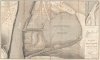
Survey for a Ship Canal around the Falls of Niagara. Plan Artificial Harbor and Project for Descent of Ridge.
1835 (dated) 29 x 48.5 in (73.66 x 123.19 cm) 1 : 1760
1835 (dated) 29 x 48.5 in (73.66 x 123.19 cm) 1 : 1760
Description
This is the 1835 William G. Williams map of a proposed artificial harbor to be used in conjunction with two of the proposed routes for a canal between Lake Erie and Lake Ontario. The harbor was ultimately constructed and is now the Niagara Water Reservoir. The map depicts the area from Queenston, Ontario, to just to the right of the proposed artificial harbor and from Lewiston, New York, to Lewiston Ridge, which the canal would have to descend.
An Artificial Harbor and Double Locks
By creating an artificial harbor, ships traversing the canal could more easily change direction to descend the further 120 feet to the Niagara River. Captain Williams, the author of this map, proposed the use of double lock system, both to descend Lewiston Ridge and to reach the river. Double locks allow for more speed and less delays. By using a double lock system, ships can travel in both directions at the same time. Double locks can also serve as holding pools when only one lock is in use. By placing basins at intervals along the lock system, it allows for ships to change between the two parallel systems of locks if, for some reason, one of the two systems became inoperable.A Closer Look
The map not only depicts the artificial harbor and the two systems of double locks, it also illustrates the surrounding area. The Niagara River traverses the map along the left side, with Queenston, Ontario on its left and Lewiston, New York on its right. An arrow indicates the direction of the current. Several buildings are depicted in both Queenston and Lewiston, although none of them are labeled. An inset map of the Termination of Line AB is situated in the upper right, and a profile diagram of one of a section of lock is located directly below it. The map is endorsed by William G. Williams in the lower right.Publication History and Census
This map was made and drawn under the direction of William G. Williams, U.S. Topographical Engineers. We note nine examples cataloged in OCLC which are part of the collections at the New York Public Library, the Boston Athenaeum, the University of Michigan, Michigan State University, Brock University, the University of Georgia, the University of Wisconsin Milwaukee, the Wisconsin Historical Society, and the Huntington Library.Cartographer
William G. Williams (1801-1846) served in the U.S. Army from 1820 until 1846. He graduated from the U.S. Military Academy at West Point and, after graduation, served on topographical cut, eventually reaching the rank of Captain. He oversaw the survey for the proposed canal around the Falls of Niagara, New York and on Lake Champlain, New York. He served as Superintendent of Survey of Northwestern Lakes from 1841-1846. The Mexican-American War broke out in 1846, where he served as the Chief Topographical Engineer of the Army commanded by Major General Taylor until September 21, 1846 when, fighting in the Battle of Monterey, he was mortally wounded and died of his wounds. He is buried in Buffalo, New York. More by this mapmaker...
Condition
Very good. Some offsetting. Backed on archival tissue for stability.
References
OCLC 166641294.