This item has been sold, but you can get on the Waitlist to be notified if another example becomes available, or purchase a digital scan.
1850 Cruchley Map of Asia
Asia-cruchley-1850$87.50

Title
Asia.
1850 (dated) 15 x 18 in (38.1 x 45.72 cm) 1 : 29570000
1850 (dated) 15 x 18 in (38.1 x 45.72 cm) 1 : 29570000
Description
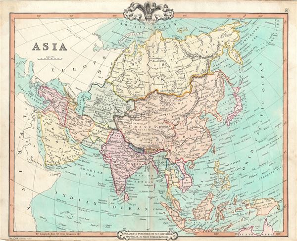
This is a fine example of George Frederick Cruchley's 1850 map of Asia. The map covers the entire continent from the Red Sea to the Kamchatka Sea and from the Arctic to the Gulf of Carpentaria. Shows the Chinese Empire including Tibet, Korea and Mongolia. Cruchley identifies both China's Great Wall and the Grand Canal. Taiwan or Formosa is mapped vaguely, representing the poor knowledge of the region prior to the Japanese invasion and subsequent survey work of 1895. Afghanistan is divided into Cabool (Kabul) and the southern province of Beloochistan (Baluchistan). The Arabian Peninsula is also included in this map. The sea between Japan and Korea, whose name, either the 'Sea of Korea' or the 'Sea of Japan,' is currently a matter of historical and political dispute between the two countries, is here identified in favor of Japan. Singapore is also identified.
As this map was drawn, Imperial China wilted under the weak Qing while the Russian attained the height of its pan-continental expansion. Turkey and much of the Middle East was under Ottoman hegemony. In India, shortly after this map was made, the Sepoys of the British East India Company would revolt in India's First War of Independence.
Cruchley's General Atlas was unique for its period, employing a vivid color scheme extending even to the oceans, distinctive typography, and various uncommon decorative elements including a peacock feather crown and an imprint medallion, both of which break the printed border. Though many of the maps in this atlas are copyrighted in 1841, the atlas was first published in 1843 from the Cruchley office at 81 Fleet Street, London, and proving popular went through numerous reissues well into the 1850s.
Cartographer
George Frederick Cruchley (April 23, 1797 - June 16, 1880) was a London based book and map seller active in the middle part of the 19th century. Cruchley began his cartographic career as an apprentice at the venerable Aaroon Arrowsmith firm. Many of Cruchley's earliest maps bear the words 'From Arrowsmith's' on the imprint. In 1844, Cruchley acquired the massive stock of the important early 19th century firm of John Cary. Cruchley published his own maps as well as reissues of Cary's stock well into the 1870s. He is best known for his detailed plans of London, which in recent years have become increasingly scarce and desirable. Cruchley was based in London on 38 Ludgate Street until 1834 when he moved his offices to 81 Fleet Street. Shortly before his death in 1880 Cruchely auctioned (Hodgson's Auctions, Jan 16, 1877) his entire stock. Many of his map plates were thusly acquired by 'Gall and Inglis' who continued the Cruchley tradition well into the early 20th century. Cruchley's son, also George Frederick (1837 - 1882), continued to work as a book and map seller until his death. More by this mapmaker...
Source
Cruchley, G. F., Selection of Maps from Cruchley's General Atlas, for the use of Schools and Private Tuition, London, 1850.
Condition
Very good. Minor wear and some toning over original centerfold. Blank on verso.